The Surprise Tropical Storm- TS Emily
Hello everyone!
With generally quiet weather today, I’m going to look back on a pretty interesting weather event that took place yesterday. In the span of just a few hours, a tropical storm formed and made landfall on the west coast of Florida. So how did this storm form and why wasn’t it in the forecast?
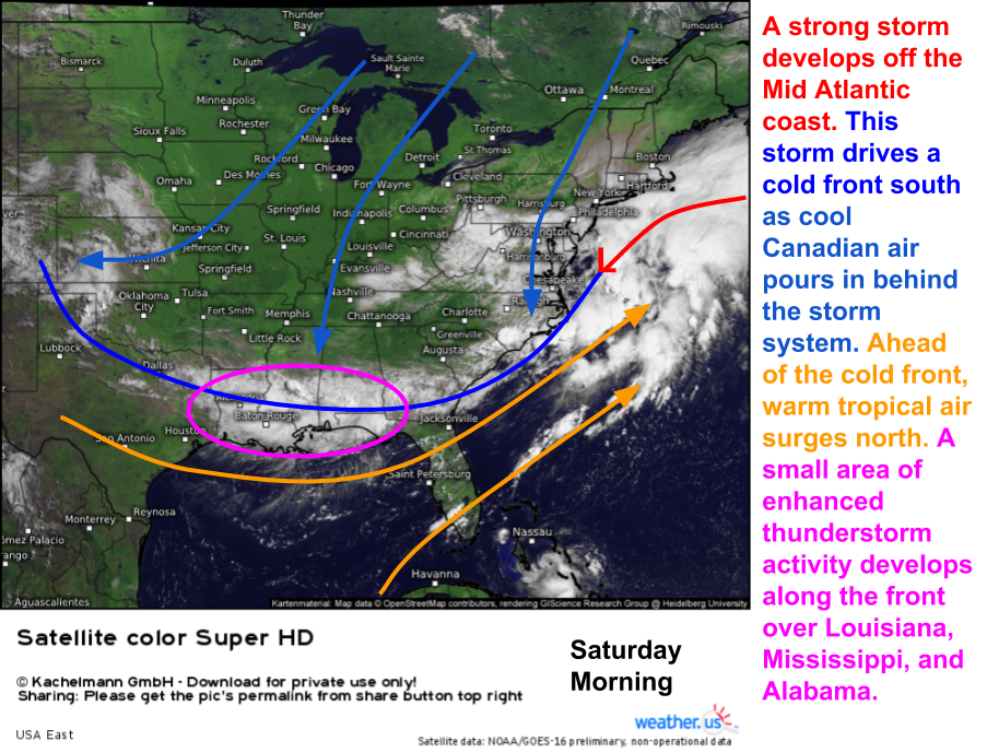
This story, like almost every story in weather, begins well before the event itself. Back on Friday night, low pressure developed off the Mid Atlantic coast, bringing torrential rains to that region. That storm was moving northeast on Saturday morning and a cold front was dragging along behind it.
There are a number of ingredients visible here that are going to contribute to the formation of TS Emily. A cold front is sagging south towards the Gulf Coast. Along it, an area of enhanced thunderstorm activity is present across parts of LA, MS, and AL. Meanwhile, behind the front, cool and dry air is surging southward.
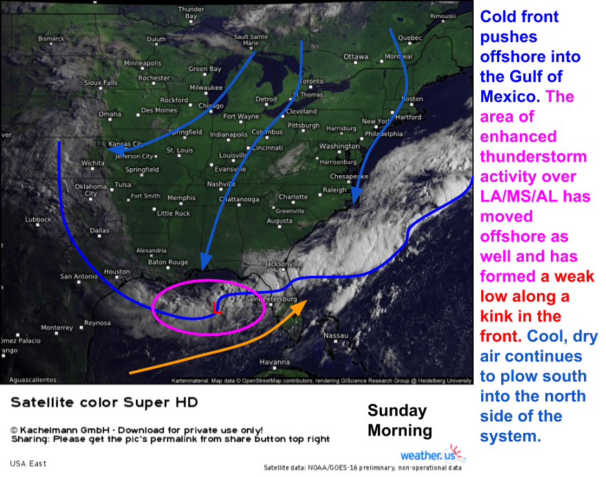
By the time we get to Sunday morning, the ingredients are set up for tropical storm development, however, it isn’t obvious a tropical storm is about to form.
The area of enhanced thunderstorm activity that was over LA/MS/AL has now moved offshore. The once mighty cold front is now running out of steam as the upper dynamics associated with the coastal low move NE into the open Atlantic and weaken. This is allowing for several kinks to develop along the front. One of those kinks is under our area of enhanced thunderstorms. A weak low pressure system forms in this area, a classic precursor to tropical storm development. However, it still isn’t obvious that a tropical storm is about to develop. Why? Cool air is streaming out of Canada and has made it all the way to the Gulf Coast. This cool, dry air inhibits thunderstorm development and organization. You can see this evident across the Eastern half of the country, where the only clouds present area a few stable stratus features over West Virginia. This dry airmass is moving into our developing low, and thus the forecast was for the system to remain weak and disorganized.
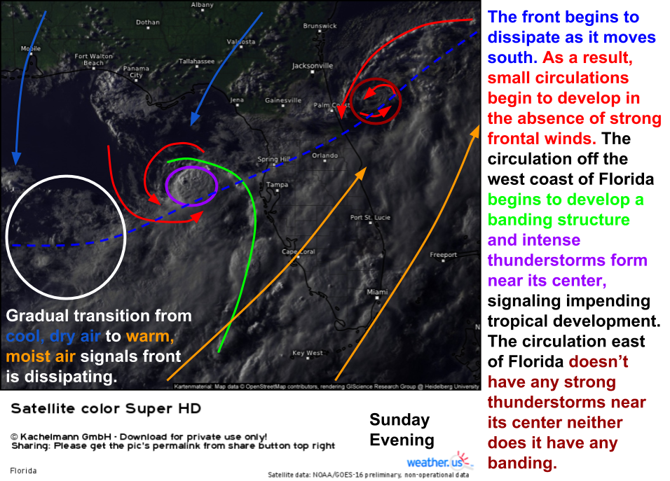
By Sunday evening, our storm is continuing to develop as the cold front dissipates. Two kinks in the front are developing circulations at this point, one west of Florida and one east. The eastern one lacks thunderstorms near its center, so it has little to no future as a tropical system. The western circulation, on the other hand, does have thunderstorms near its center. It’s also beginning to develop banding on the southeast side. However, the impacts of the dry air and wind shear are still evident as the system remains lopsided. Notice how all the thunderstorms are SE of the center with clear skies NW.
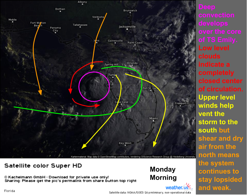
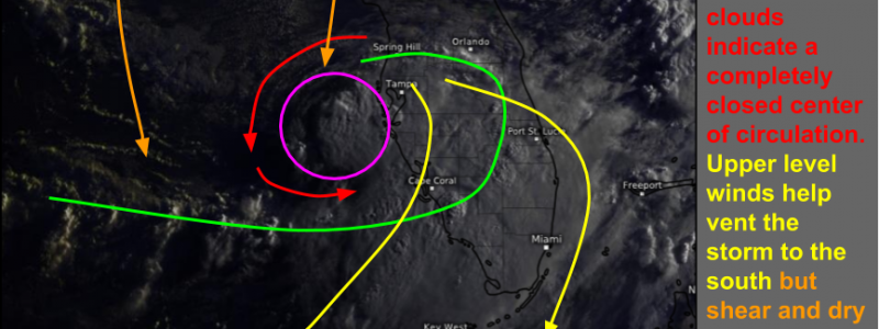
By Monday morning, TS Emily was named by the NHC. Deep convection (thunderstorm activity) was noted near/over the center of the storm. Banding was developing to the southeast, and upper level winds were helping to vent the “spent” air that no longer had any energy left, off to the south. However, dry air and wind shear continued to plague the storm’s northwestern side with little to no thunderstorm activity occurring there.
Radar imagery from Monday morning shows the same features satellite imagery does. Only a few hours after development, the thunderstorms near the center of the storm are beginning to organize into an eyewall type structure. Thankfully for Florida, dry air and wind shear prevented this eyewall from closing off and the storm from strengthening even more. This storm intensified rapidly enough as it was.
Emily made landfall yesterday morning just south of Tampa. A weak tornado formed just NW of the center as it moved onshore and caused some damage, but overall impacts from the system were relatively light. What made Emily so unusual was that it developed very quickly and very unexpectedly. Most forecasts, including mine, called for the low over the Gulf of Mexico to weaken as it crossed the Florida peninsula. The NHC gave the low a 20% chance of developing into a tropical storm Sunday evening. The thinking was that the dry air and wind shear brought in by the cold front would prohibit development. As it turned out, both did help inhibit development, but the warm waters of the Gulf of Mexico drove enough persistent thunderstorm activity that the low was able to fend off the mitigating factors just enough to develop into a weak tropical storm.
Currently Emily is a tropical depression that is moving NE away from Florida and out into the open Atlantic where it will become absorbed by the cold front that gave birth to it. No additional impacts to land are expected.
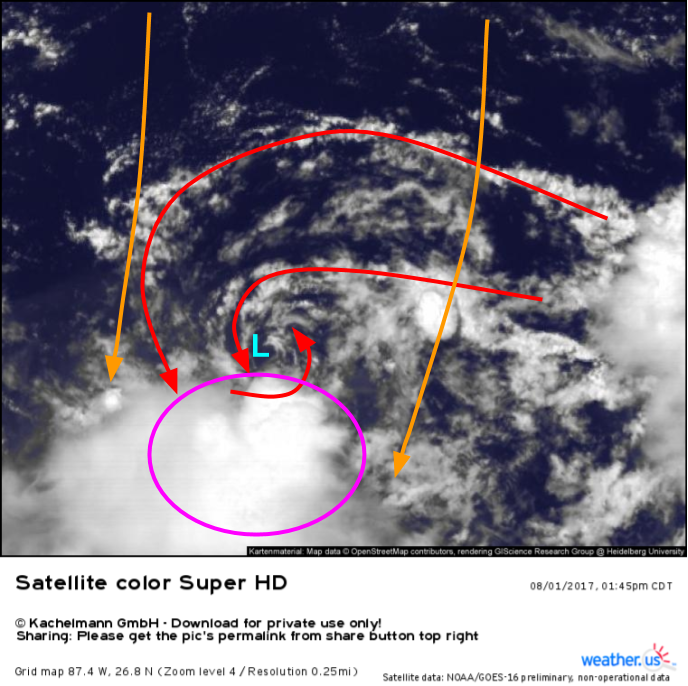
Another swirl has formed over the Gulf of Mexico along the same front that gave rise to Emily. While dry air and wind shear (orange arrows) are currently winning the battle against this low, it will have to be watched in the coming days. It could very well surprise us, just like Emily did. I’ll let you know in the coming days if this low looks to develop. However, you don’t have to wait for me! You can look at the same stuff I’m looking at over at weather.us. I’ll be using GOES-16 satellite data especially to watch for trends with this system. I’ll be watching to see if the vorticity (spin) in the low levels continues, and if any thunderstorms can develop/persist over the center of the system. You can watch for these things too!
-Jack Sillin
