• Storms Rumble Through the Northeast
  • The Winds of Change
  • Concerning Cyclones
  • Common Severe Weather Soundings Explained
  • Plains States Severe Set-up

blog.weather.us

» go to weather.us
» go to weathermodels.com
Menu
  • Home
  • Categories
    • Forecasts and Analysis
    • Weather encyclopedia
    • Noteworthy Weather Events
    • Tutorial Videos
    • Editorials
    • Weathermodels.com
  • Our Authors
    • all posts by Meghan
    • all posts by Jacob
    • all posts by Dr. Ryan
    • all posts by Joerg
    • all posts by Jack
  • weather.us
    • Forecast Essentials
    • Forecast Light
    • Forecast XL
    • Model Charts
    • Doppler Radar HD
    • Lightning Detection
    • Satellite Images (GOES 16)
    • Precipitation Total
  • weathermodels.com

rapid intensification Post

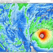
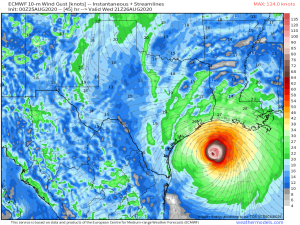
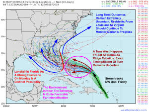
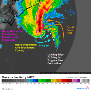
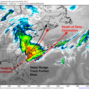
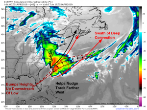
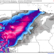
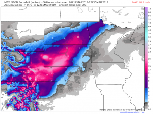
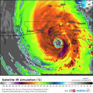
Laura Rapidly Intensifying Into A Major Hurricane This Morning, Landfall Expected Tonight Near The TX/LA Border

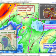
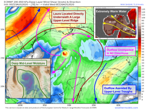
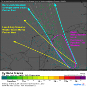
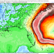
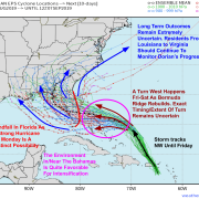
Hello everyone! Laura continues to rapidly intensify in the Gulf of Mexico this morning and is well on its way to becoming an extremely dangerous Category Four hurricane by tonight. …
by Jack Sillin/ 08/26/2020/ 3 Comments/

Laura Likely To Threaten The Upper Texas Coastline As A Major Hurricane Tomorrow Night

Hello everyone! Laura has now emerged into the Gulf of Mexico as a strong tropical storm and is taking full advantage of the favorable environment for intensification. The storm is …
by Jack Sillin/ 08/25/2020/ 1 Comment/

Making Sense Of Model Forecasts For Tropical Storm Laura

Hello everyone! Much attention is being paid to weather model forecasts of Tropical Storm Laura this afternoon as the system looks to threaten the US Gulf Coast as a hurricane …
by Jack Sillin/ 08/23/2020/ No Comments/

Tropical Storm Laura Moving Over Hispaniola This Morning, Likely To Make Landfall On The Northwestern Gulf Coast As A Hurricane On Wednesday Or Thursday

Hello everyone! Laura and Marco both remain strong tropical storms this morning as they move towards the US. Marco appears to be attempting to intensify this morning, and is likely …
by Jack Sillin/ 08/23/2020/ 2 Comments/

TD 14 Poised To Intensify In The NW Caribbean While TD 13 Struggles With Dry Air And Shear East Of The Lesser Antilles

Hello everyone! We have two tropical entities to keep an eye on as we approach the weekend: TD 13 and TD 14. Initial thoughts on each system were posted yesterday …
by Jack Sillin/ 08/20/2020/ No Comments/

Dorian Now A Dangerous Category Four Hurricane, Eventual Track Becoming A Little Clearer

Hello everyone! Hurricane Dorian completed a remarkable rapid intensification cycle yesterday evening with its maximum winds increasing from 110 mph to 140 mph in just 12 hours. The storm has …
by Jack Sillin/ 08/31/2019/ No Comments/

Hurricane Dorian Continues To Strengthen This Morning, Extent Of Florida Impacts Remains Somewhat Uncertain

Hello everyone! Hurricane Dorian continues to strengthen this morning with the 8 AM NHC advisory indicating the storm is now producing 110 mph winds with a central pressure of 972 …
by Jack Sillin/ 08/30/2019/ 1 Comment/

Dorian Reaches Hurricane Status Near Puerto Rico, Will Threaten Florida By Labor Day

Hello everyone! The tropical system we’ve been following in the Caribbean, Dorian, has reached hurricane status this evening with peak winds of 80 mph as of the 8 PM EDT …
by Jack Sillin/ 08/28/2019/ No Comments/

Intensifying Nor’easter Putting On A Dynamical Show Off The Carolina Coast This Afternoon

Hello everyone! Instead of my usual forward-looking forecast based posts, I want to take a more current (or, by the time you’re reading this, slightly retrospective) look at the ongoing …
by Jack Sillin/ 04/02/2019/ No Comments/

Will A Powerful Ocean Storm Impact The East Coast This Week?

Hello everyone! Despite the fact that we’ve now turned the corner into April and spring is in full swing, we’re still watching for a possible nor’easter off the East Coast …
by Jack Sillin/ 04/01/2019/ No Comments/

Rapidly Intensifying Storm To Bring A Major Blizzard To The Northern Plains Tomorrow

Hello everyone! A remarkable display of atmospheric dynamics is just getting underway across the Central part of the US this evening as two powerful upper level disturbances join forces to …
by Jack Sillin/ 03/12/2019/ No Comments/

Train Of Strong Storms To Continue Impacting The Pacific Northwest This Week

Hello everyone! The first in a series of strong Pacific storms is impacting parts of the Pacific Northwest this evening, and several more are set to bring similar impacts through …
by Jack Sillin/ 12/16/2018/ No Comments/

Michael Only Continuing To Intensify As It Bears Down On Florida

Hello everyone! Michael is not slowing down as it prepares to slam into the Florida Panhandle. The storm underwent rapid intensification last night, with its maximum sustained winds now at …
by Jack Sillin/ 10/10/2018/ No Comments/
  • 1
  • 2
  • 3
  • 4

Share us

Share on Facebook
Facebook
Tweet about this on Twitter
Twitter
Share on Google+
Google+
Pin on Pinterest
Pinterest
Share on Tumblr
Tumblr
Email this to someone
email

Our authors

Meghan

Ryan
Dr. Ryan

Joerg
Joerg

Guest author

Jack

John

Jacob

Tags

2020 Hurricane Season atmospheric river Bermuda High California CAPE coastal storm cold front ensembles EPS fall flooding forecast gusty winds hail heavy rain high pressure hurricane pattern quiet quiet weather rain rapid intensification science severe weather snow spring storm storms summer Swiss Super-HD Model Texas thunderstorm composite thunderstorms tornadoes tropical cyclone tropical storm tropical wave Tropics tutorial uncertainty video weather weather.us weathermodels.com winter

Recent Posts

  • Storms Rumble Through the Northeast
  • The Winds of Change
  • Concerning Cyclones
  • Common Severe Weather Soundings Explained
  • Plains States Severe Set-up

WeatherOK Inc.

  • Omega, OK
    United States
    [email protected]
    Contact

Legal

  • Terms & Conditions

Follow Dr. Ryan

Follow us

Follow weather.us

Copyright © WeatherOK Inc. All rights reserved