How Might TD13 And TD 14 Interact In The Gulf Of Mexico And What Is The Fujiwhara Effect?
Hello everyone!
TD 13 and TD 14 are still moving towards the Gulf of Mexico this morning. The official NHC forecast, as well as most model guidance, suggests that both systems will be located in the Gulf by early next week. This raises a tricky but important question: what happens if two tropical cyclones are in close proximity to each other? Normally when we talk about forecasting tropical cyclone track and intensity, we look to the storm’s surrounding environment for clues. That environment is usually characterized by a mix of upper-level troughs and ridges. But what happens when one storm’s nearby environment contains another storm? Providing some more clarity regarding that question is the aim of this post.
A necessary assumption in exploring this question is that both TD 13 and TD 14 will be strong tropical storms or hurricanes when they arrive in the Gulf of Mexico. This is far from a guarantee! To become a strong TS or hurricane, TD 13 will need to emerge from its ongoing battle with wind shear containing a closed vortex and some amount of persistent deep convection. Then it needs to avoid the Greater Antilles while (re)building its core. That scenario shouldn’t be ruled out, but it also shouldn’t be considered a foregone conclusion. For TD 14, the biggest challenge today will be firing up some thunderstorm activity near its center. Given the very warm waters in the NW Caribbean and the generally favorable upper-level environment, I don’t think the storm should have a problem getting this done by tonight or tomorrow morning. The question will then be how quickly it can get its act together. But for the sake of this post, we’re just going to assume both storms can get their respective acts together and enter the Gulf as coherent, reasonably strong cyclones.
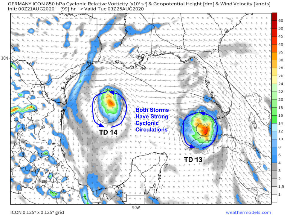
The 00z ICON model depicts what I think is the most reasonable depiction of this scenario were it to occur, so I’ll use it for the purposes of explaining how these storms might interact. The key idea here is that each storm has a strong cyclonic circulation that is embedded within its larger environment. In this case, the larger environment is characterized by a large ridge to the NE of the Gulf which is resulting in prevailing SE winds. However, in this case, there is another component to the environmental flow which is the circulation of the other storm.
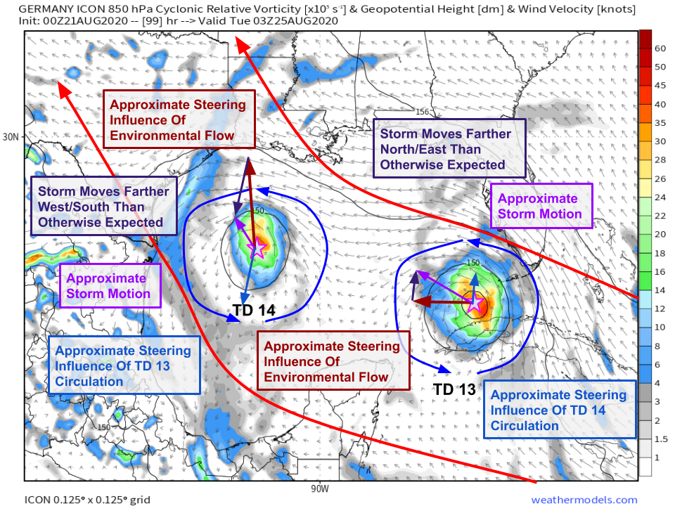 This looks a little complicated, but the basic idea is relatively simple: we now need to introduce a new term in our steering “formula”. Instead of just looking at the ridge NE of the system (and the trough NW of the system which doesn’t show up on this low-level wind map), we also need to consider the influence of the other storm’s circulation. This new “term” will be stronger or weaker depending on how close the systems are together and how strong they each are. The ICON model expects TD 13 to be the dominant system, so its influence on the track of TD 14 is much stronger than TD 14’s influence on TD 13.
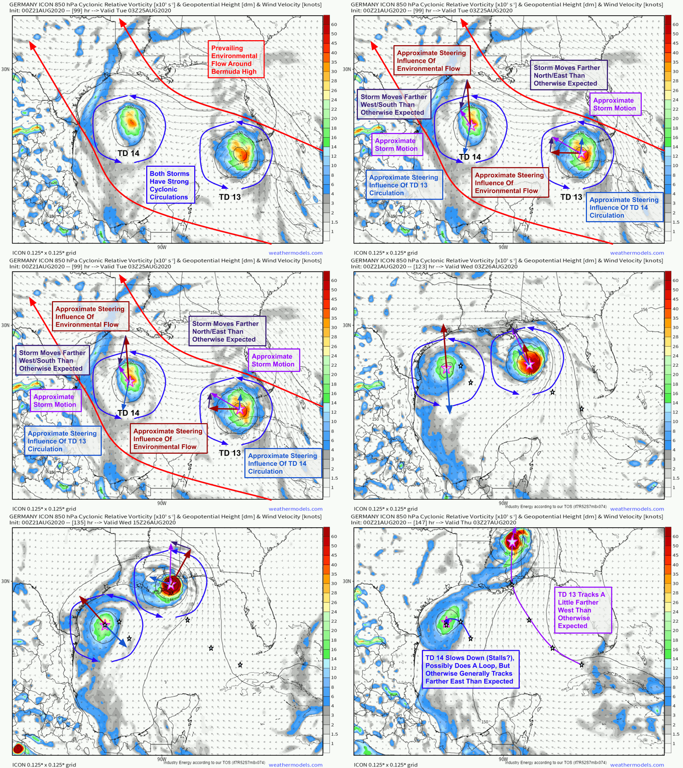 This animation provides a rough and qualitative look at how the influence of the each storm’s circulation might alter the track of the other system. I’ve tried to make the vectors roughly to scale, but if you were to do the rigorous quantitative analysis as described by Galarneau and Davis (2013) which involves inverting the laplacian of the vorticity and divergence fields, you might get something that looks slightly different. If most of the words in the previous sentence sounded like complicated gibberish, that’s quite understandable! Now you know why I opted for qualitative hand-drawn vectors rather than quantitative computer-done analysis.
This type of “binary interaction” is known as the Fujiwhara Effect after Japanese meteorologist Sakuhei Fujiwhara who discovered the phenomenon.
The upside is that TD 14 would likely be slowed down and possibly tugged a little farther east (eventually) by TD 13, and TD 13 would be accelerated and possibly tugged a little farther west (eventually) by TD 14. So we’ve covered the track implications of this interaction. What about intensity?
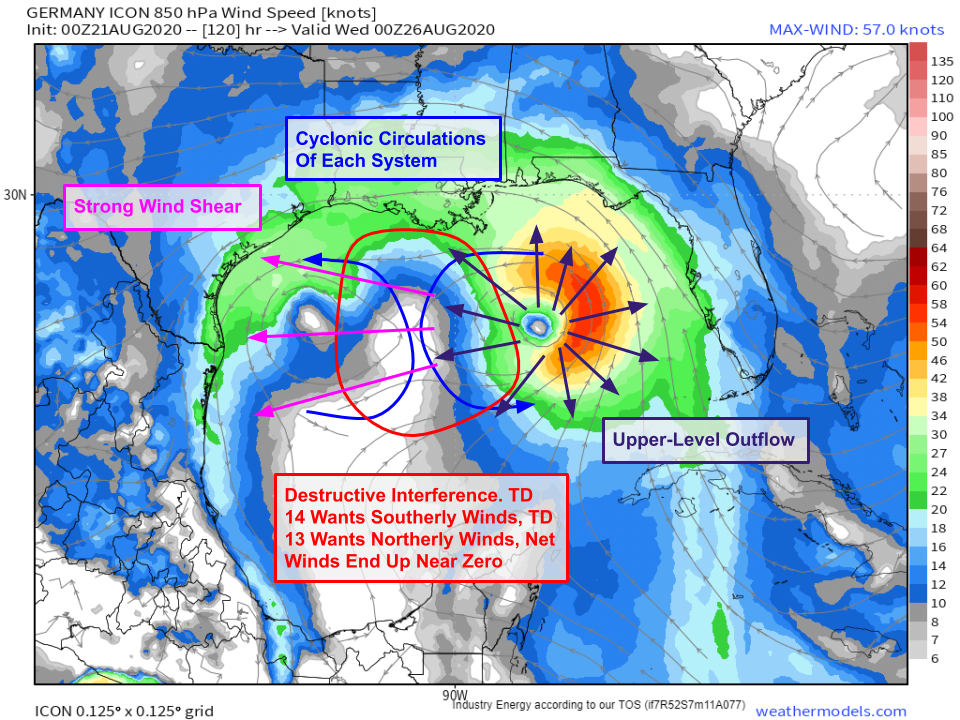 Thankfully, any worries about the two storms merging into a “super-hurricane” are unfounded. When tropical cyclones arrive in close proximity to another tropical cyclone, the interaction is detrimental for both storms. The reasons for this are twofold: destructive interference of low-level circulations and increase in upper-level wind shear. This is particularly true when one storm is much stronger than the other, as is forecast here by the ICON. In the lower levels of the atmosphere, two circulations spinning in the same direction near each other will “cancel each other out” where they meet. In this case, over the Gulf of Mexico south of central Louisiana, TD 14’s circulation wants to produce southerly winds and TD 13’s circulation wants to produce northerly winds. The net result is almost no wind. If there’s no wind, the cyclones can’t access heat and moisture from that part of their circulation. The net result is a detrimental effect on the cyclone’s circulation. In the upper levels of the atmosphere, latent heat release by each storm produces a divergent circulation where winds spiral outwards from the center. This produces strong upper-level winds over the other storm, which as we know from discussing wind shear, is detrimental to a tropical cyclone’s convective organization. If one storm (TD 13 in the case of the ICON forecast) is much stronger than the other, the weaker system will usually weaken substantially or dissipate as a result of the interaction.
So while it still remains to be seen whether TD 13 and TD 14 will interact in the Gulf of Mexico, their mingling (were it to occur) would not be cause for concern. Most likely, one would end up a little weaker and the other would end up a lot weaker, with some adjustments to the track of each. Either way, residents of the Gulf Coast should be looking over their hurricane plans and making sure they’re ready to act if told to do so in the next several days.
I’ll have another update later this afternoon looking at what’s most likely to happen with each system.
-Jack


Impressive! Thanks for the article.
King regards,
Harrell Valenzuela