Will A Powerful Ocean Storm Impact The East Coast This Week?
Hello everyone!
Despite the fact that we’ve now turned the corner into April and spring is in full swing, we’re still watching for a possible nor’easter off the East Coast this weekend. The storm is likely to be a fairly powerful one despite the late season timing, but the big question is whether or not it will come close enough to the coastline to bring serious impacts. This post will outline some of the factors that will play into the forecast track of the storm, and will offer a quick overview of what’s to be expected weather-wise in the east this week. If you’re looking for info specific to your town/area, head on over to weather.us and enter your desired location into the search box or explore our wide library of graphical forecast data.
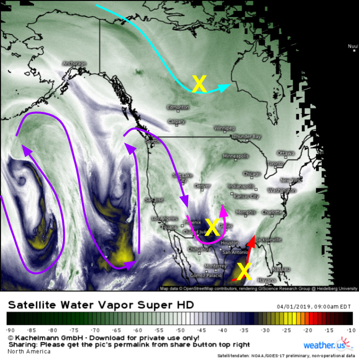
GOES-17 WV satellite imagery gives a good overview of the pattern this morning, with each of the three disturbances that we’ll be watching in the coming days. The first is located in the Gulf of Mexico, while the second is currently moving through Oklahoma. Those two systems will join forces over Georgia tomorrow to get our storm going. Then it will be up to disturbance number three up in Canada to either steer the storm up the coast, or out to sea. One other interesting thing to note is the very wavy pattern in the jet stream over the Pacific Ocean. That is a notable change from most of the winter, when winds in that region have blown more or less straight west to east. The amplification of the Pacific pattern is a primary reason why we’re even discussing the possibility of this system bringing impactful weather to the East Coast.
Here’s a look at the pattern on Tuesday as the storm approaches the point where it either turns up the coast, or turns out to sea. As you can see, there are lots of factors at play here. I think there are two basic possibilities with the northern disturbance, one of which would send the storm closer to the coast and the other of which would bump it out to sea. The “closer to the coast” outcome would happen if the northern stream disturbance is weaker and sags farther south into the Great Lakes. That would open up room for the storm to move farther north before the incoming disturbance swept it away into Canada. If that northern stream disturbance is stronger and slides farther east, it would close the door on northward movement, and turn the storm to the east much faster. Map via weathermodels.com.
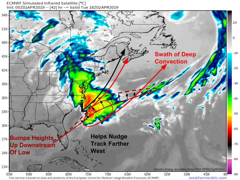
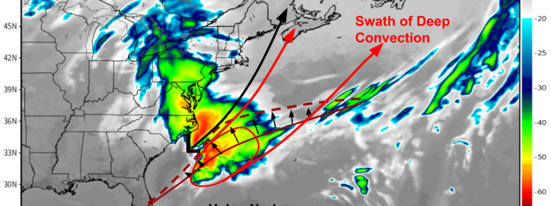
The northern stream disturbance is just one of the sources of uncertainty regarding the storm’s track. Another important factor will be how much convective activity (thunderstorms) develops downstream of the storm. Thunderstorms release lots of heat into the upper atmosphere due to all the water vapor they lift upwards condensing and eventually freezing. This heat gives a boost to the ridge of high pressure that forms downstream of the low pressure system. Ridges act like pinball bumpers of sorts for low pressure systems, deflecting them away from the center of the ridge. The more heat gets added to the ridge, the more it will expand towards the northwest, which means the farther it will bump the storm northwest. This could counteract some of the impact of a less-favorable northern stream disturbance, should that outcome end up playing out. With all that in mind, what does each possible outcome look like, and which is to be expected? Map via weathermodels.com. For more on how convection can influence east coast storm tracks, check out this post I did last winter.
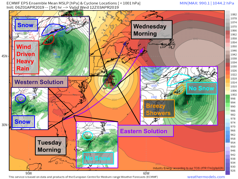
This graphic may initially seem complex, but it is designed to present a bunch of information as succinctly as reasonably possible. The base map is the EPS’s ‘range of possible outcomes’ map for the storm’s position on Wednesday morning. You can see some disagreement between the ensemble members, indicating some uncertainty as different models handle that northern stream disturbance a bit differently. At two points along the storm’s track I’ve inserted a comparison of what each possible solution looks like in more practical terms. The western solution is from last night’s ECMWF run, while the eastern solution is from this morning’s GFS run. Note that even the western ECMWF model doesn’t forecast a major coastal storm. The primary areas interested in the forecast discrepancy here are NC/SC and New England. Under the slower/stronger/farther west solution, far interior NC/SC could see some mixed precipitation tomorrow morning as precipitation gets thrown back into a marginally cold airmass. Note that this wouldn’t happen with the eastern solution as precip wouldn’t make it far enough NW to find the cold air. Later on in the storm’s life cycle on Wednesday morning, New England may see moderate to heavy rain and inland snow if the storm tracks farther west, while breezy showers would be limited to Cape Cod if the system moved farther east. Evidently it will be important to figure out which solution is more likely, so lets take a look at that. Map via weathermodels.com.
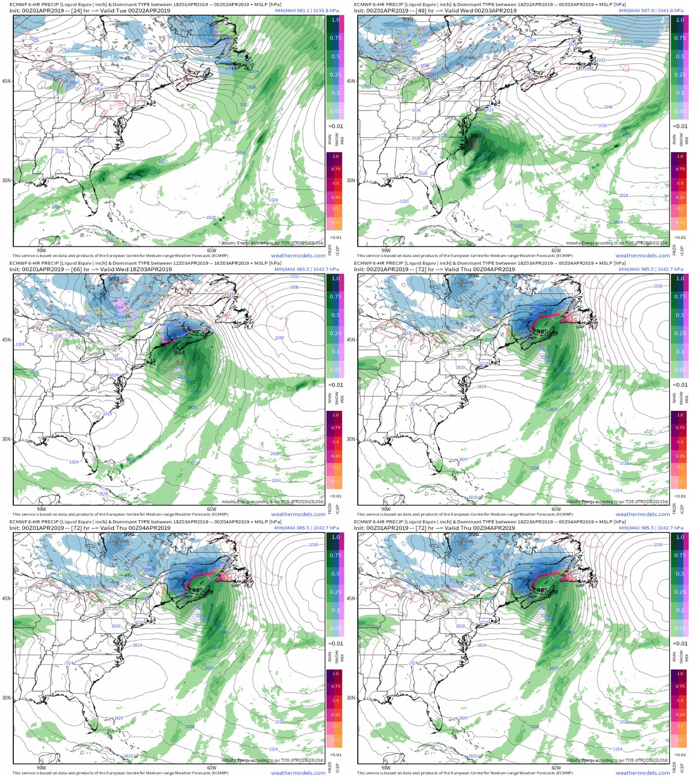
Here’s an animation showing last night’s ECMWF forecast for the system from its origins in the Gulf of Mexico to its eventual departure into Canada. I think this is is the more likely outcome, on the farther west edge of the track envelope. Again, this is not going to be a major storm for the entire East Coast. It will begin with rain over the Southeast tonight/tomorrow morning, that will mix with some light snowflakes over parts of far NW SC and SW NC. No accumulations are expected. The storm will bring heavy rain and some breezy conditions to the Outer Banks tomorrow evening as rapid intensification of the storm begins. By Wednesday morning, heavy rain and strong winds will be impacting Cape Cod and adjacent parts of SE MA, while light to moderate snow falls across interior Northern New England. Thankfully the strongest winds should remain offshore, but Cape Cod should still see gusts in the 40-50 mph range, which will be substantial enough for at least some power outage concerns. GIF via weathermodels.com.
The storm will quickly exit into Canada on Wednesday evening as the northern stream disturbance arrives in New England, bringing strong westerly flow aloft with it.
As always, more specific info for your town can be found at weather.us.
-Jack
