Widespread Severe Weather Returns Tomorrow And Saturday As Storm Develops In The Plains And Moves East
Hello everyone!
After a few days of generally quiet weather, the threat of fairly widespread severe storms will return tomorrow as an area of low pressure develops in the Plains and begins moving east. Storms will bring all modes of severe weather from parts of Northeast Texas through Arkansas and into Missouri tomorrow, before the threat shifts into the Deep South Saturday.
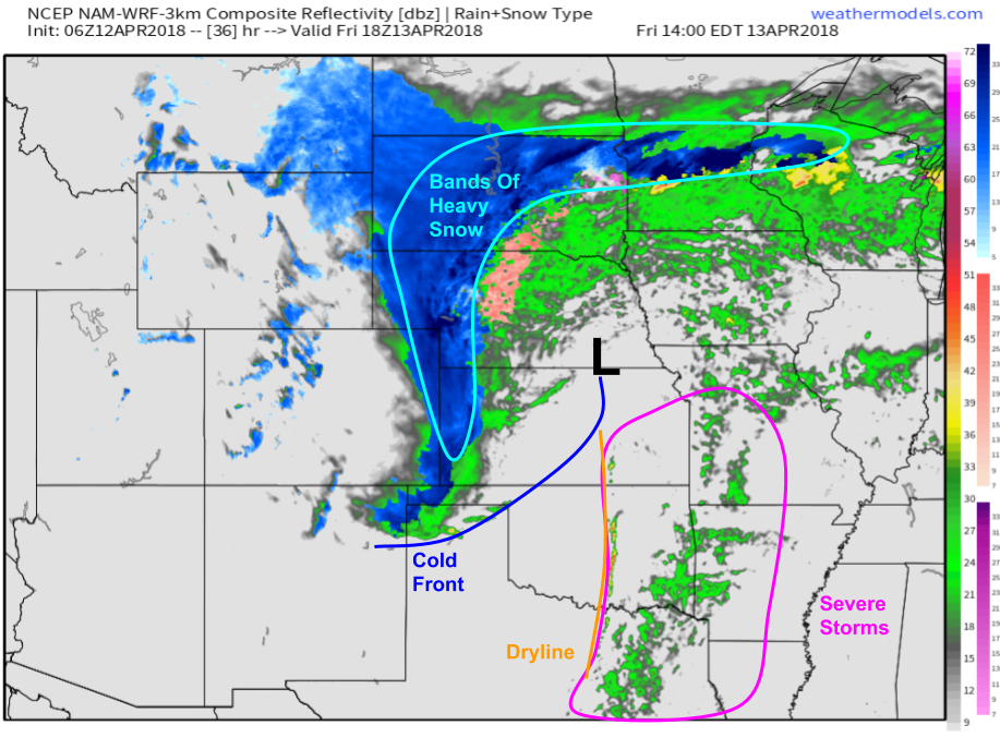
Here’s a look at the big picture tomorrow afternoon. The storm system in question will be moving through Kansas and Nebraska with bands of heavy snow developing northwest of the low, and strong to severe storms developing southeast of the low. Some storms will develop along the cold front near the low’s center, but most of the activity will be focused along the dryline from Southeast Kansas through Northeast Texas. Storms developing in this area will pose the greatest threat for severe weather. Map via weathermodels.com.
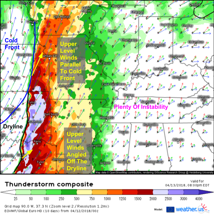
The exact threats posed by storms will depend on the storm mode in any given area. Discrete storms have the potential to develop into supercells which would bring the threat of hail and tornadoes in addition to damaging winds. Storms that are organized into linear clusters will primarily pose a damaging wind threat, with some tornadoes possible. One way to see which storm mode may prevail in any given area is to look at the orientation of mid/upper level winds relative to the boundaries on which storms are forecast to develop. This can be done with the ECMWF’s thunderstorm composite product (what’s that?). Looking at the type of boundary is also helpful. Cold fronts are more conducive to linear clusters, while drylines (boundariers between dry and moist air of similar temperatures) typically favor more discrete cells. When mid/upper level winds are oriented perpendicular to a dryline, conditions are favorable for discrete supercells. A dryline will be the boundary to watch from NE Texas through E Oklahoma, and mid/upper level winds will be oriented at about a 45 degree angle to the boundary. This isn’t quite a textbook supercell setup, but should be favorable enough for a few discrete cells to develop especially earlier in the afternoon/evening. Farther north, upper level winds are oriented nearly parallel to the cold front in E Kansas and W Iowa. This will favor a more linear storm mode. Eventually, the discrete storms that form along the dryline will congeal into a line of storms, but that won’t happen until later in the evening.
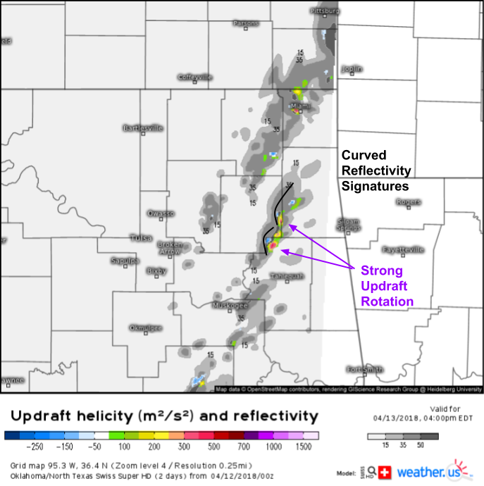
Here’s a map from our Swiss Super HD 1x1km model giving some insight into storm structures in eastern Oklahoma tomorrow evening. The grey shading is reflectivity (simulated radar) while the colored shading is a parameter known as Updraft Helicity which measures how fast the updrafts of storms are rotating. As you can see, the model is predicting a couple of discrete storm cells to have curved reflectivity signatures and strongly rotating updrafts, both signs that large hail and tornadoes will be possible tomorrow afternoon before storms merge into a line later in the evening.
By Saturday, the threat for severe weather will be shifting east into the Deep South. Model projections indicate a line of storms leftover from Friday’s activity moving through parts of LA and MS midday tomorrow as daytime heating ramps up ahead of the cold front. With the linear storm mode, damaging winds will be the main threat, though tornadoes are always possible along the leading edge of a line like this, especially with surface winds out of the southeast, as is forecast along the Gulf Coast. Why do southeasterly winds favor tornadoes? With winds prevailing out of the WSW aloft, any easterly component to the low level wind greatly increases the change in wind direction with height, also known as wind shear, which is an important ingredient for tornado formation. Map via weathermodels.com.
While there are still some uncertainties as to exactly how the severe weather threat will evolve both tomorrow and Saturday, there is high confidence in impactful severe weather occurring both days. Be sure to have a way to receive critical warning info from the NWS, and follow the storms’ every move with our HD radar https://weather.us/radar-us (now with custom zoom options!), GOES-East satellite imagery https://weather.us/satellite/satellite-water-vapor-superhd-5min.html, current observations https://weather.us/observations/temperature-f.html, and high resolution model forecasts https://weather.us/model-charts/conus-hd. Click any map to zoom in for a closer look, and explore other options/parameters via the menus to the left of each image.
I’ll have another update later today detailing the winter weather threats posed by this storm.
In the meantime, find more information on the forecast for your town at weather.us, and find more information on the local forecast for ME/NH at forecasterjack.com.
-Jack


