What’s Next In The Tropical Atlantic? Two Disturbances To Watch After Dorian
Hello everyone!
Now that Dorian is a post-tropical low, and quickly moving into the far northern reaches of the Atlantic, it’s time to shift our attention back to the deep tropics and see if there are any other systems to watch for potential future tropical cyclone development. There are two such systems out there, but neither poses a significant nor an imminent threat to the US. This post will outline the forecast for those two systems as they move slowly westward over the next several days.
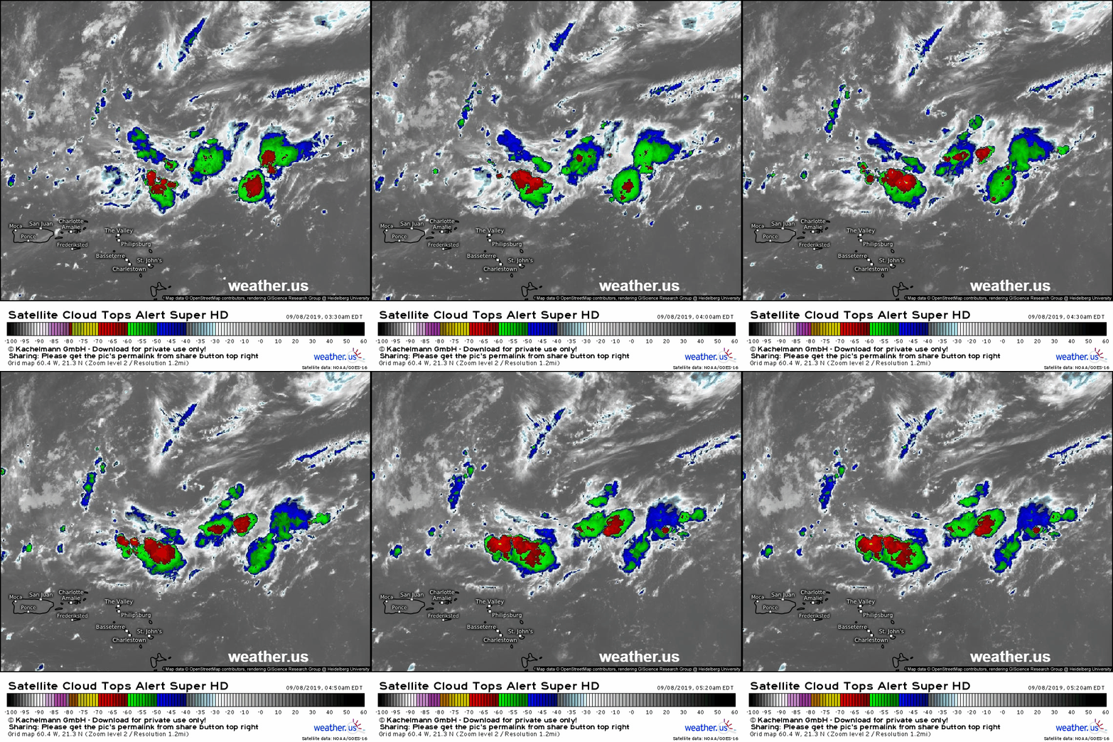
The first system to watch is currently located ENE of Puerto Rico. As you can see on the satellite imagery above, it is quite poorly organized. The spin you see just north of the thunderstorm activity has more to do with an upper level low in the area which will need to dissipate before this disturbance has a chance at developing.
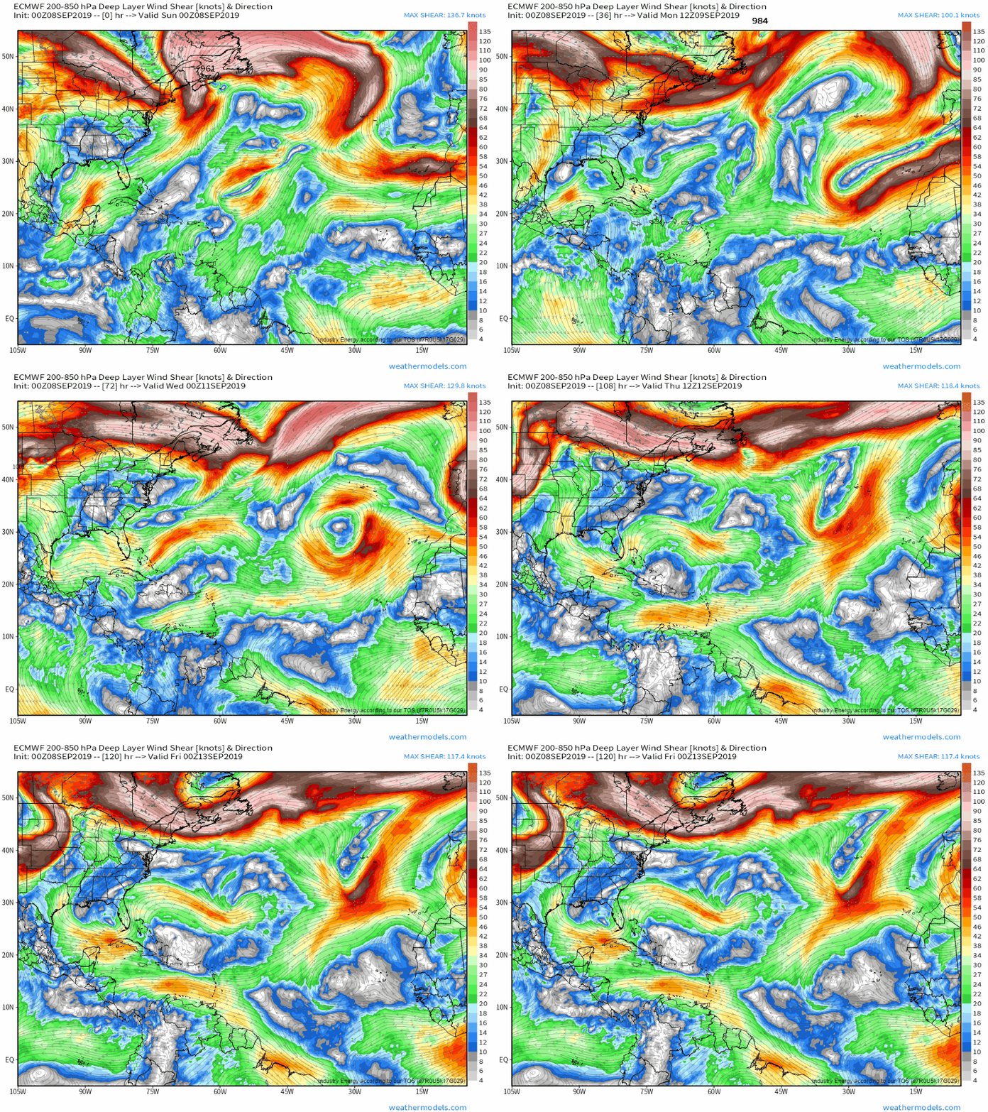
The upper level low in question shows up clearly at the beginning of this shear forecast from the ECMWF before dissipating early this coming week. By the time the loop ends, the disturbance will be located in an environment with very low shear over the Southern Bahamas. Whether the system will be in a position to take advantage of that environment or not has yet to be determined, but the dissipation of that upper level low and the movement of the system into that pocket of very light shear a few days from now gives some indication that development will become possible a few days from now. GIF via weathermodels.com.
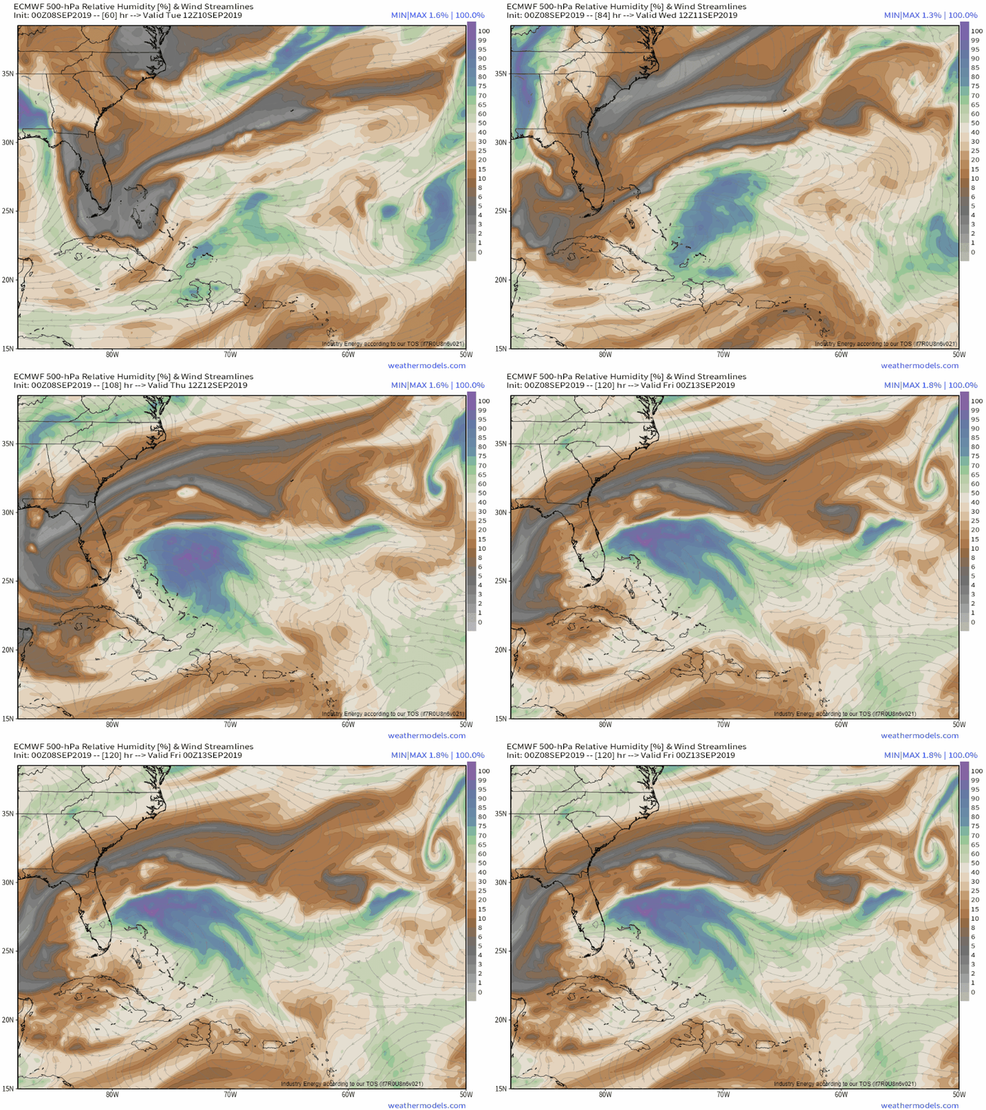
As far as dry air goes, there shouldn’t be too much around the system by the time it reaches the favorable shear environment. You’ll notice though that there’s plenty of dry air to the west of the system on the loop above. That’s associated with a strong upper level low that will be diving SW through Florida while the disturbance drifts into the Bahamas. Depending on how fast and how strong that upper low is, it may impart enough shear and dry air onto the system for it not to develop. On the other hand, if the upper level low drifts far enough west, it may help contribute to a more favorable upper level environment by increasing divergence aloft (which favors upward motion through the atmosphere). GIF via weathermodels.com.
Overall, this system has a chance of developing later this coming week, but it’s not much to worry about right now. It will arrive (developed or not) in Florida on Friday with some showers and breezy conditions. If I was in Florida, I would not be worried about this system but I’d aim to check the latest forecast info once a day or so this coming week to see if anything’s changed.
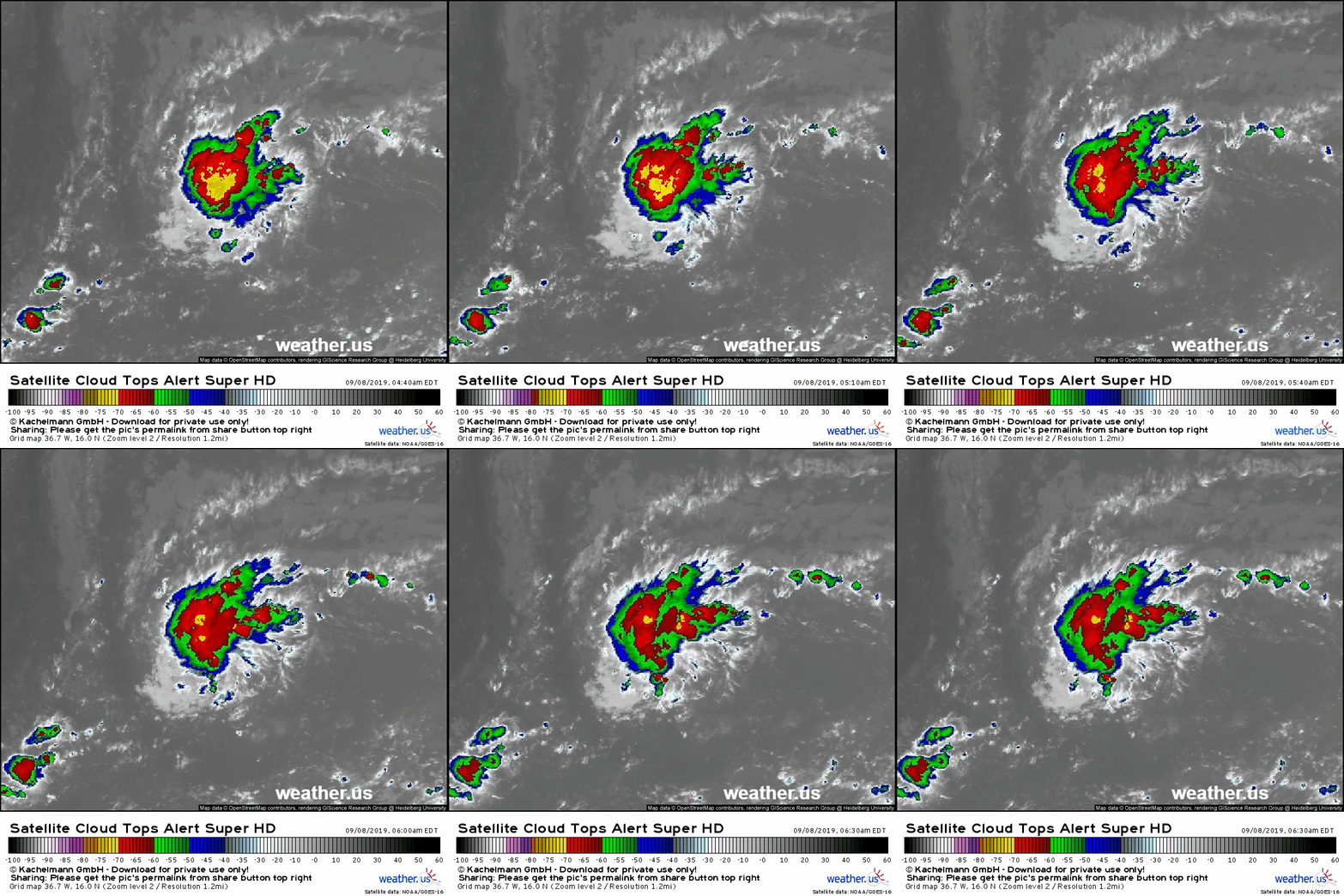
The other system to watch is much farther east in the Atlantic, but it’s also much better organized. This disturbance is sufficiently interesting to the NHC to have been deemed “Invest 94L”. The system has some persistent convection and developing upper level outflow, but still has yet to develop a robust low level circulation. Satellite wind data from earlier this morning suggests that the low level center of the storm is located just SE of that area of deep convection, which means that even if it were to close off a circulation, it would need to build some thunderstorm activity overhead to become a tropical cyclone.
The system is forecast to remain in an environment with low shear and moist air over the next several days, so it will have ample time to get organized. I think it’s fairly likely we see a tropical cyclone of some sort develop from this system before it reaches the Leeward Islands approximately a week from now. 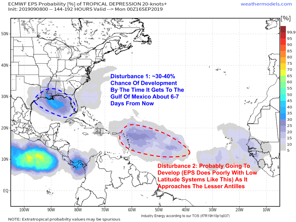
Here’s a look at what the EPS’ tropical cyclone formation probability product shows for each system. I think it has a good handle on disturbance 1 (currently ENE of Puerto Rico) which has probably a 30-40% chance of becoming a tropical depression (or storm) by the time it reaches the Gulf of Mexico 6-7 days from now. That’s enough to keep a half an eye out (i.e. check forecasts around once a day) but certainly not enough to be really concerned about. Map via weathermodels.com.
As for disturbance 2 (that’s 94L), I think the EPS is underestimating its chances of development which are higher than disturbance 1’s based on the environment (wind shear, dry air, etc.). The EPS has a known bias to underestimate the odds of lower latitude systems like this as they approach the Lesser Antilles. We saw that most recently with Dorian where the ECMWF and EPS didn’t see the storm developing until it was already developed. With that in mind, I think that the NHC is about right when it says that there’s a 40% chance of tropical cyclone formation from this system within the next 5 days. If I were to set my own probability, it would probably be closer to 50 or 60%, but the difference is negligible.
We’re a long way off from having to worry about 94L, if we ever do, here in the mainland US. The storm won’t get to the Lesser Antilles for 7-8 days, and it will be another 6-7 days from there to Florida. Most likely, as is the case with the majority of tropical disturbances, it will find something to succumb to in the next two weeks, but we’ll be watching just in case.
For those curious, the climatological peak of hurricane season is in just two days (September 10th) which means that having this much activity in the Atlantic is completely normal for this time of year.
-Jack
