What Is The Dryline And How Does It Impact Severe Storm Formation?
Hello everyone!
With the Great Plains severe thunderstorm season now getting underway, it’s a great time to take a look at a phenomenon known as the dryline. The dryline is a key ingredient for severe thunderstorm formation in the Plains, and while you can get thunderstorms without drylines, the most photogenic and chaseable cells often have something to do with this feature. This post will give a brief background on what exactly the dryline is, and will use a case study from May 2017 to show how it can be important in touching off severe thunderstorm development.
All the archived data I pulled for this post is freely available at weather.us via the calendar button in the menus next to any of our images. Check out this video for more info on exploring our extensive library of old weather data.
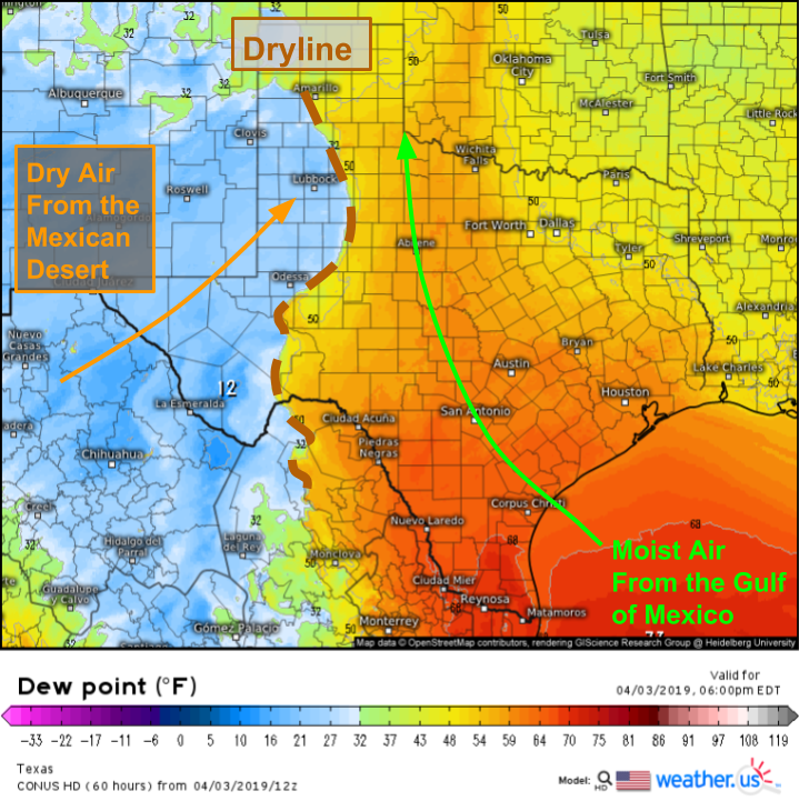
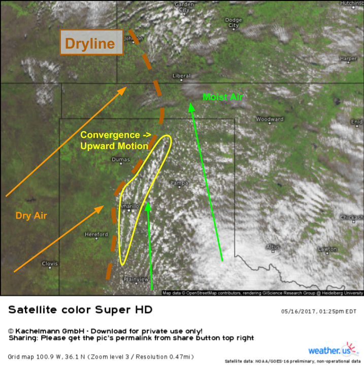
A dryline is defined simply as a boundary between airmasses that have similar temperatures, but different moisture levels. It’s different from a front (like warm front or cold front) in that one airmass isn’t blasting the other one out of the way, nor does the boundary have much if any thermal gradient. That said, there are some similarities between drylines and fronts. Both mark the boundary between two airmasses of different characteristics, and both have a convergent wind field which means that winds on either side of the boundary are blowing towards the boundary. In the case of the dryline, winds on the dry side of the boundary are southwesterly while winds on the moist side of the boundary are southeasterly. That convergence is why we care about this feature in the context of severe thunderstorm forecasting. To highlight how this boundary can spark severe thunderstorm development, let’s take a look at a case study from May 2017 in the Texas Panhandle.
Here’s a visible satellite image from before convective initiation (the time the first thunderstorm develops). The dryline is clearly visible as the boundary between air that’s too dry to support any clouds and an area that has enough moisture for a bunch of clouds. Looped imagery, observations, and conceptual knowledge of the dryline all tell us that winds are converging around Amarillo Texas. Sure enough, we see cumulus that are taller and puffier in that area compared to surrounding areas. We can tell just from the “texture” of the image that these clouds are taller and puffier without even being on the ground. Wonder how I’m getting to that conclusion? Compare the clouds near and especially NE of Amarillo with the clouds near Plainview TX (to the south of Amarillo, east of the dryline). After looking at a lot of satellite imagery, these are the sorts of neat things you can pick up on.
If the dryline is a boundary between airmasses that features converging winds, what makes it different from a frontal boundary especially in the context of severe storm forecasting? The answer has to do with how much power a front has to lift air parcels vs how much power the dryline has.
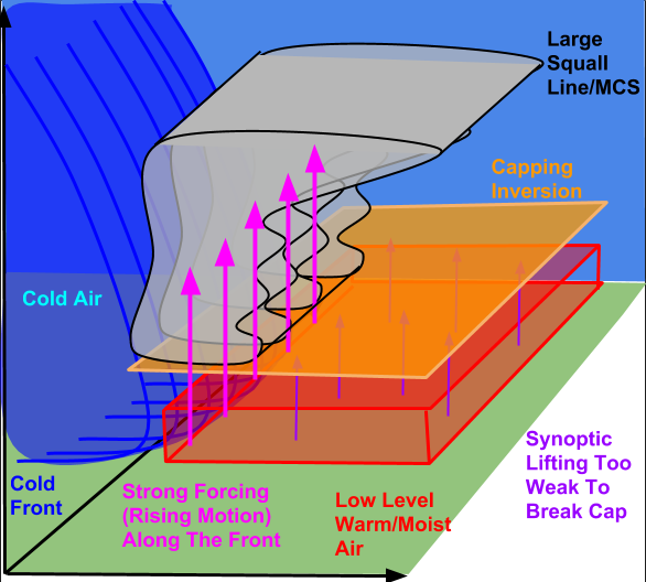
First let’s take a look at the case of the cold front. The environment out ahead of the front is assumed characterized by warm moist air near the surface, which is prevented from rising by a “capping inversion” or layer of warm air aloft (read more about that here). The cold front marks the western edge of this airmass, with much cooler and drier air behind it. In the case of the cold front, the post-frontal airmass is much denser than the pre-frontal airmass. This enables the cold air to rush forward, shoving warm air parcels upward en masse. This forcing occurs along the length of the front, which results in a long line of storms along the boundary. These lines are known as squall lines, sometimes referred to by their more technical name “quasi-linear convective systems” or QLCS’s. These storms are known primarily for their damaging winds, though can also produce tornadoes along their leading edge if enough low-level wind shear is present.
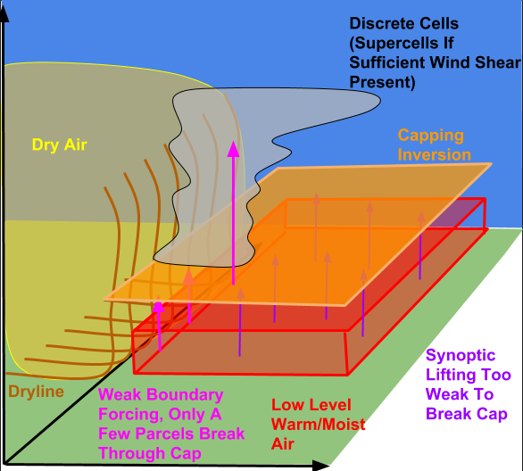
In the case of the dryline, we see something different. The dryline doesn’t provide the same powerful displacement force that the cold front does. That’s because the density difference between a warm dry airmass and a warm moist airmass isn’t nearly as stark as that between a warm moist airmass and a cool dry airmass. As a result, the lifting provided by the dryline isn’t nearly as intense as the cold front’s lifting. This means that at most only a few parcels of low level warm/moist air can bust through the cap to form a storm. Many days, the dryline sits idle unable to lift any parcels to the level needed for storm initiation. With this more sporadic forcing comes more isolated storms that can more easily evolve into supercells.
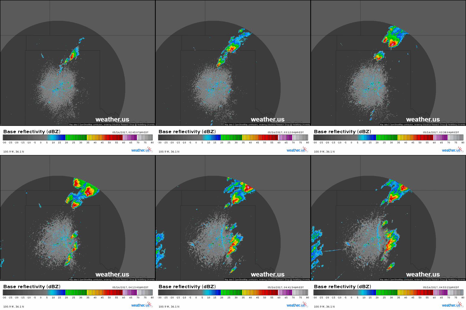
This is the radar loop from the aforementioned May 2017 dryline case in Texas. The boundary itself becomes visible as a thin blue line as the loop goes on, and the developing storms help reinforce the moisture gradient. Note that the storms developing on the dryline are discrete cells instead of a line. That’s consistent with what we’d expect given the theoretical discussion above.
Discrete cells are more apt to turn into supercells, given favorable conditions, and dryline setups are good at producing discrete cells. Supercells can produce all modes of severe weather including damaging winds, very large hail, tornadoes, intense lightning, and torrential downpours. Because of their propensity to produce discrete supercells, dryline setups can be particularly dangerous. However because the upward motion along the boundary is weak relative to that along a cold front, drylines often fail to produce any storms at all, resulting in what storm chasers refer to as a ‘blue sky bust’.
You can track the dryline with dew point observations across the South-Central US, or with radar if the boundary is close enough to a radar tower.
-Jack




Very helpful info overall for noobs like me. It did leave me with a question though and that is what makes the dryline more apt to produce on some days than others? From what I gathered, there’s always a dryline somewhere, but its just not always ripe for the development of supercells.