What Is High and Low Pressure?
Hello everyone!
I mention high and low pressure in my forecasts daily and so does every other weather forecaster out there. On weather.us, you can look at current observations of surface pressure and some of our most valuable tools for forecasting involve surface pressure. So what is surface pressure, what are high and low pressure centers, and how do they impact our weather?
The surface pressure is defined as the amount of pressure the atmosphere exerts on a particular location at the earth’s surface. The molecules that make up our atmosphere have mass, just like all molecules. The earth’s gravity exerts a force on these molecules, just like it does to all things that have mass within its gravitational field. If gravity didn’t hold the molecules in our atmosphere against the surface of the earth, the gasses would diffuse out into space and we’d be without an atmosphere.
The air pressure is not equal across the earth’s surface. Of course there are mountains and valleys that can have high or low pressure simply because of their altitude, but even if you average it all out to the mean sea level pressure (MSLP), there are areas of higher pressure and there are areas of lower pressure. This is because not all airmasses have the same density. Very dense airmasses will “weigh” a lot more, and thus exert a lot more pressure on the surface than a “lighter” airmass. Because cold air is denser than warm air, there are naturally areas of high pressure in very cold airmasses and areas of low pressure in very warm airmasses. However, this isn’t the end of the story.
There can be warm areas of high pressure and cold areas of low pressure, right? Pressure is as much determined by airmass temperature as it is the direction of the winds. North, east, south, or west doesn’t matter much here. What does matter is up or down. If air is rising through the atmosphere (winds blowing up), there’s a sort of “mini vacuum” that occurs at the surface as air is pulled upwards. This relieves some of the pressure the air is putting on the surface, therefore resulting in an area of low pressure. In fact, rising air is one of the key features associated with low pressure areas. The opposite is true for high pressure where sinking air adds pressure by forcing more and more air against the surface.
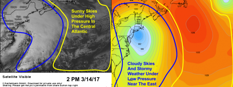
The rising and sinking patterns of air associated with high and low pressure systems are what drive our weather. In order for clouds and precipitation to form, air needs to rise, cool, and condense. It can do this much more easily in/near areas of low pressure, where air is rising, as opposed to high pressure, where air is sinking. As a result, you’ll often find clouds and precipitation near low pressure centers while sunshine often abounds in/near high pressure centers. Of course, the atmosphere is much more complicated than this and there are exceptions to both rules, but understanding high and low pressure as well as their impacts on our weather is an important first step towards understanding our atmosphere as a whole.
Now that you know more about high and low pressure, as well as how they impact our weather, check out our collection of MSLP forecasts to see what kind of system might be headed your way!
Feel free to send me an email if you have any questions about the weather you’d like me to explain! jack@weather.us
-Jack Sillin




What nobody ever explains is this: air is a fluid, so why doesn’t pressure equalise instantly? Why are there high- and low-pressure areas, which try to equalise by means of wind? Why isn’t air pressure universally uniform?
Hi Alan, this is a good question! There are many answers, but the most important one lies in the unequal heating of the earth by the sun. Cold air is denser than warm air, which means that it will exert more pressure on the surface (high pressure). Because the earth’s temperature distribution is never homogeneous, neither is the pressure distribution. For all the effort by winds to equalize, there is an equal effort from unequal heating that pushes in the opposite direction.