What is an MCS?
MCS’s are responsible for a large number of weather phenomenon. They produce the vast majority of the rainfall that occurs across the Great Plains and through the Great Lakes/Ohio Valley during the summer. They can produce extraordinary swaths of wind damage that can stretch for hundreds of miles. In addition, they are often prolific lightning producers. So what are MCS’s and how do they form?
MCS stands for Mesoscale Convective System. It’s defined simply as an organized group of thunderstorms that is larger than a single thunderstorm, and smaller than a synoptic scale storm system. This generally means that they last for between 3 and 6 hours and span the length of a state or two. This is larger than an individual storm that’s often only large enough to impact a single town and lasts between 15 minutes and an hour. However, it is also smaller than synoptic storm systems, such as nor’easters, that last for several days and can span across entire continents.
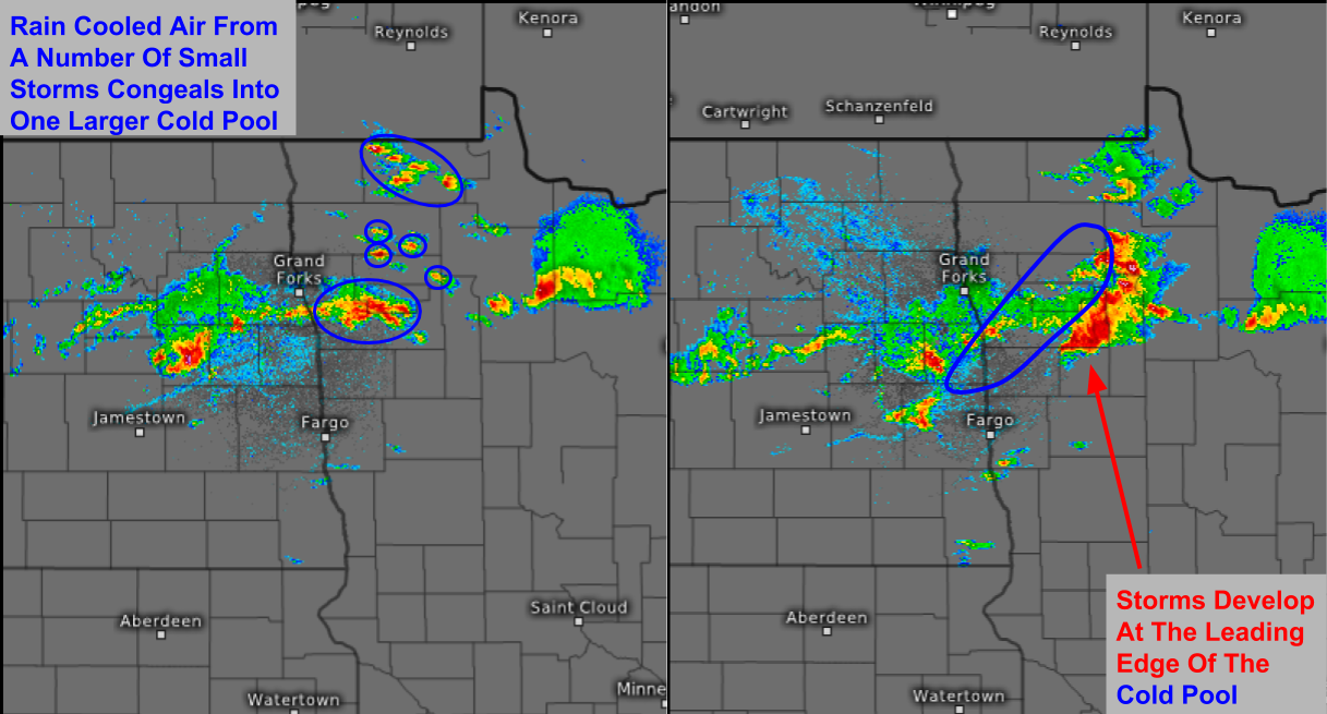
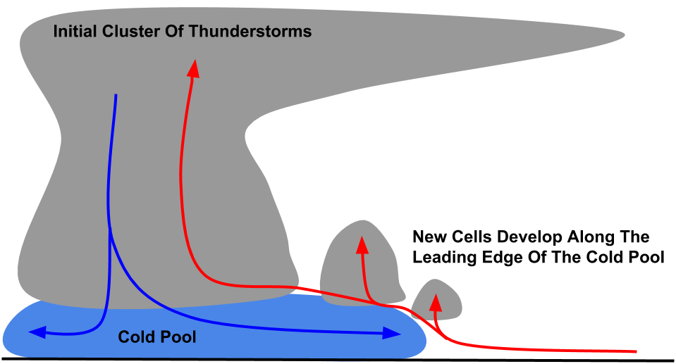
So how does an MCS form? MCS’s are formed from a process known as upscale growth. This is basically when the rain cooled air from several storms join forces to create a larger cold pool. This cold pool spreads out along the ground and acts as a mini cold front, triggering new storms as it moves along. Let’s look at an example from Northern Minnesota.
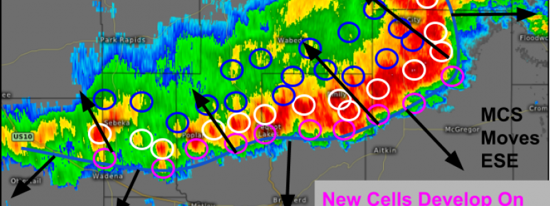
This was an example from 7/21/17 over Northern Minnesota. It shows a classic MCS evolution. As daytime heating gets underway, scattered storms form. Each of them has an updraft and accompanying downdraft where rain cooled air rushes towards the ground. When these downdrafts hit the ground, they spread out. Given the close proximity of these storms, the downdrafts soon begin to join forces and they gradually form a larger pool of cold air known as “the cold pool”. This cold pool begins to move out across the surface. At the leading edge of the cold pool, new storms form as warm, unstable air is forced to rise.
Our MCS in MN shows this process extremely well. Notice how the cold air surging southeast from the original cluster initiates a line of strong storms as it plows through the unstable airmass present in the area. So how do MCS’s maintain themselves over long periods of time and long distances once they form?
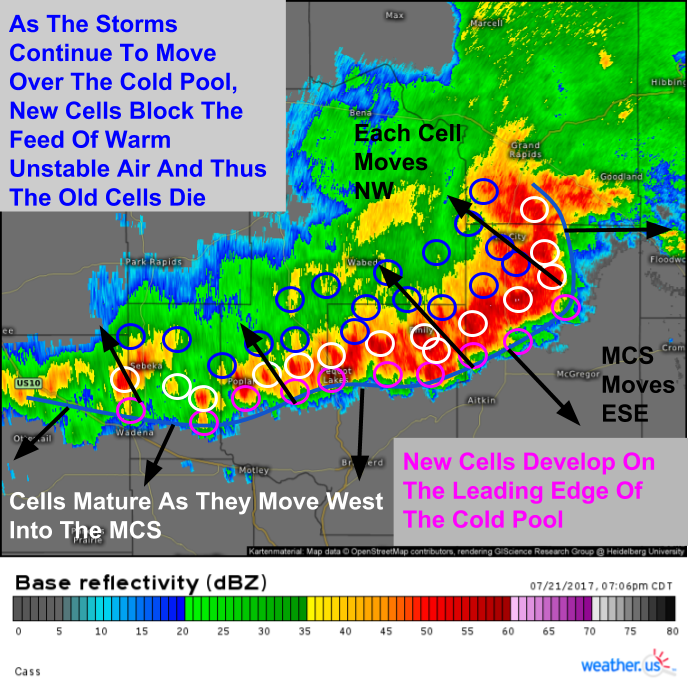
Here’s an illustration of how MCS’s develop and move over time. Not shown is the process that kills off the cells at the back of the system. As the storms move up and over the cold pool, they gradually become cut off from their supply of warm, unstable air. As a result, they slowly die off and are replaced by new cells developing at the front of the system. This constant cycle can enable MCS’s to propagate forward for hours on end as they cover hundreds of miles.
Once again, our MN MCS shows the idealized process almost perfectly. Each individual cell (circle on the map) develops along the leading edge of the cold pool, moves up and into the MCS itself, then dies off as it ejects out of the back of the system. Each cell itself moves northwest. However, the system as a whole moves east-southeast.
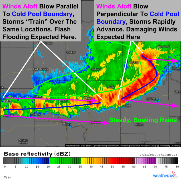
Back at the beginning of this post, I mentioned some of the impacts of MCS’s. They’re responsible for both lots of rain, and lots of wind damage. So how does each occur? The cold pool is curved in just about every MCS due to a number of factors, including the Coriolis force which ensures that no force goes un-curved. Winds aloft, however, curve much more slowly, partially because they’re driven by continent-scale patterns as opposed to state or county scale patterns. Therefore, the relationship of winds aloft to cold pool boundary orientation is important. At the “front” of the MCS, the could pool boundary is oriented more or less north/south. Winds aloft are out of the west. Therefore, the winds aloft blow perpendicular to the cold pool boundary. Extreme turbulence within the thunderstorms mixes some of these strong winds towards the surface where they can be used to push the cold pool even more quickly ahead. As a result of the fast storm motion and involvement of the upper level winds, damaging winds are often found in this area.
Back to the west, winds are blowing parallel to the cold pool boundary. As a result, the cold pool boundary slows its southward motion as there’s nothing to keep it moving in that direction. Instead, new cells continue to form and move along/across the boundary as discussed before. The thing here though is that the boundary either stalls out or moves very slowly as the cells move overhead. The result is storms “training” over the same areas over and over again, much as the same stretch of railroad track sees traincar after traincar move along it. The result is torrential rains that often result in flash flooding. Another source of heavy rain is the remnants of the cells that move across the cold pool boundary. As these cells die off and become elevated above the cold pool, their torrential rains become much lighter and steadier, therefore resulting in beneficial rains for the areas the fast moving part of the MCS moves over.
Now that you know more about MCS’s, how they work, and what impacts they bring, be sure to keep an eye on the radar to see if any are headed in your direction!
Feel free to send me an email if you have any questions about the weather you’d like me to explain! jack@weather.us
-Jack Sillin
