Wet Pattern To Continue Across The Southeast This Week
Hello everyone!
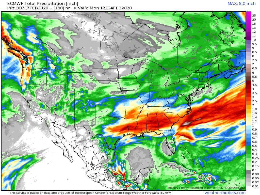
This week will feature a continuation of the wet pattern that has been in place across the Southeast for the past 180+ days. While it’s not clear that any particular day will feature widespread flooding, the forecast rain falling on already-full rivers and already-saturated soils is sure to exacerbate ongoing flood concerns. This post will outline why more rain is expected in the Southeast this week, and which days are particularly worrisome for additional flooding.
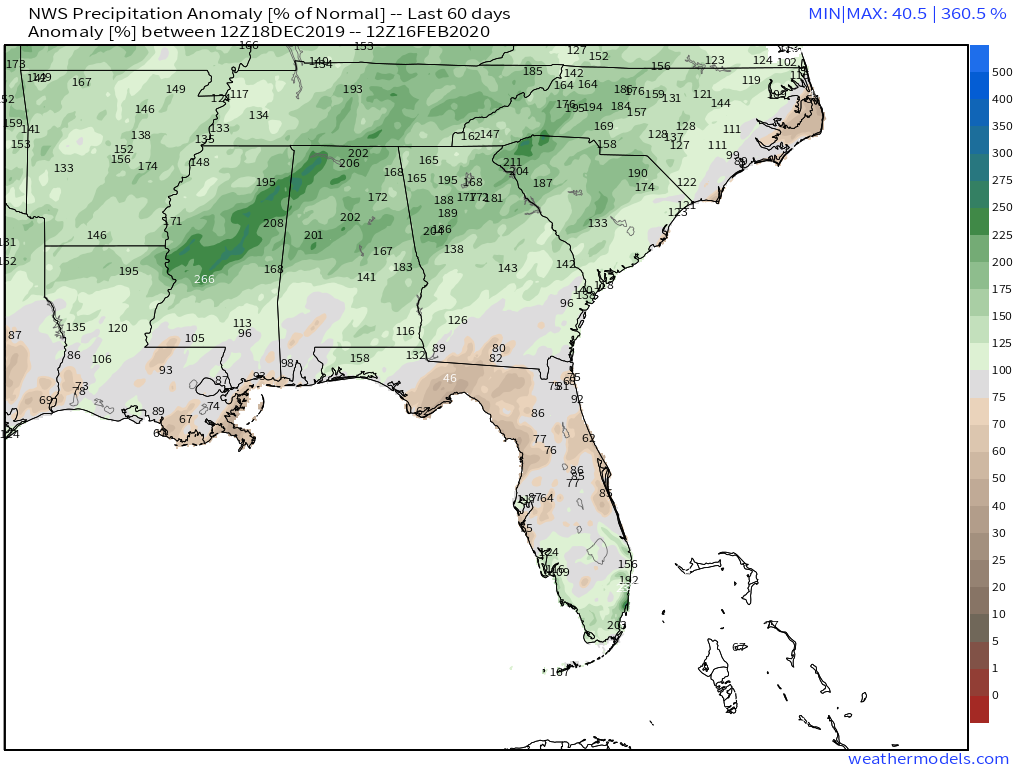
Any discussion of potential flooding events should start with a look at the antecedent conditions. As I mentioned above, most of the Southeast is running well above normal in terms of precipitation. I’ve selected the 60 day precipitation anomaly to display here, but the map looks pretty much identical if you go back 180 days. Precipitation anomalies >200% over such a long period are a strong indication that soils in this area are already saturated, and rivers/streams already at or near bankfull.
Now that we know the hydrological system in the Southeast is primed for additional flooding, what does the atmospheric pattern look like?
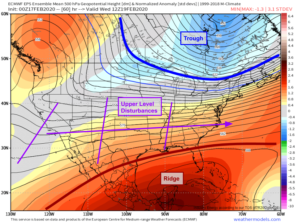
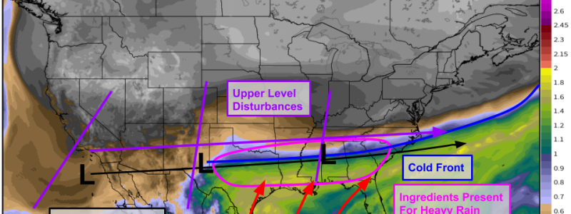
This week’s general pattern is well summarized by the EPS 500mb height anomaly forecast for Wednesday morning. A large ridge will be anchored over Cuba while a large trough will linger over far northern Quebec. Strong zonal (westerly) flow between these features will characterize the upper level environment over much of the US. Upper level disturbances embedded within this westerly flow will bring showers and thunderstorms to areas that have access to sufficient moisture.
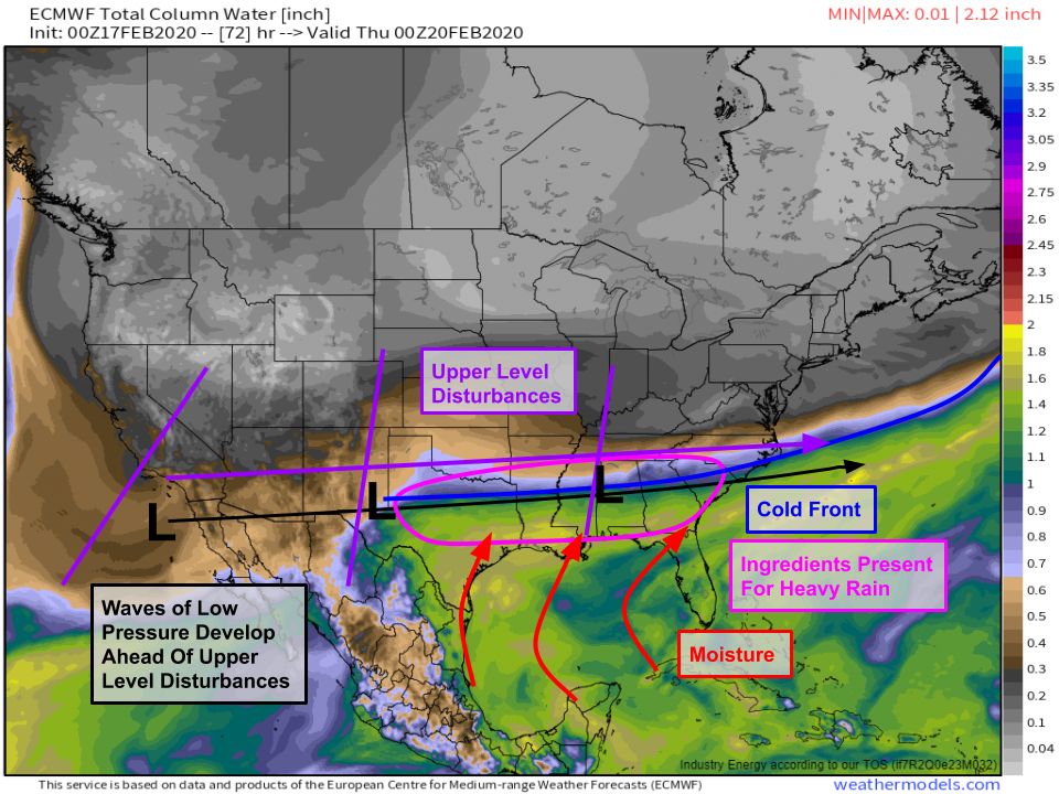
Taking a look at precipitable water forecasts in addition to the upper level pattern allows us to begin honing in on the area most likely to experience repeated rounds of heavy rain this week. A cold frontal boundary trailing a storm east of Newfoundland is clearly evident from western Texas through the Deep South on Wednesday. South of this boundary, seasonably deep tropical moisture is moving north out of the Gulf of Mexico. Areas of low pressure will form along the aforementioned cold front as those upper level disturbances move east. These lows will be able to tap into the tropical moisture and produce heavy rains roughly within a hundred or so miles of the front itself. The front won’t be stuck in this position over the course of the whole week, but it won’t stray all that far. Similarly, each area of low pressure won’t produce the same amount of rain over the same areas, but at least we now have a general idea of where the ingredients necessary for heavy precipitation might come together.
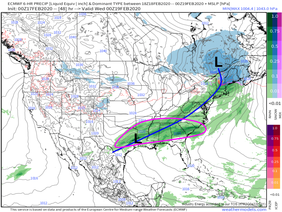
Having developed a sufficiently thorough understanding of the general pattern, we can now look at the waves of low pressure individually. The first will form as the frontal boundary arrives in the area tomorrow evening. Showers and storms along and ahead of the boundary/wave will drop a general 1-3″ of rain with locally higher amounts possible where individual storm cells linger. This wave will move offshore on Wednesday morning with a period of drier weather to follow on Wednesday afternoon/evening. 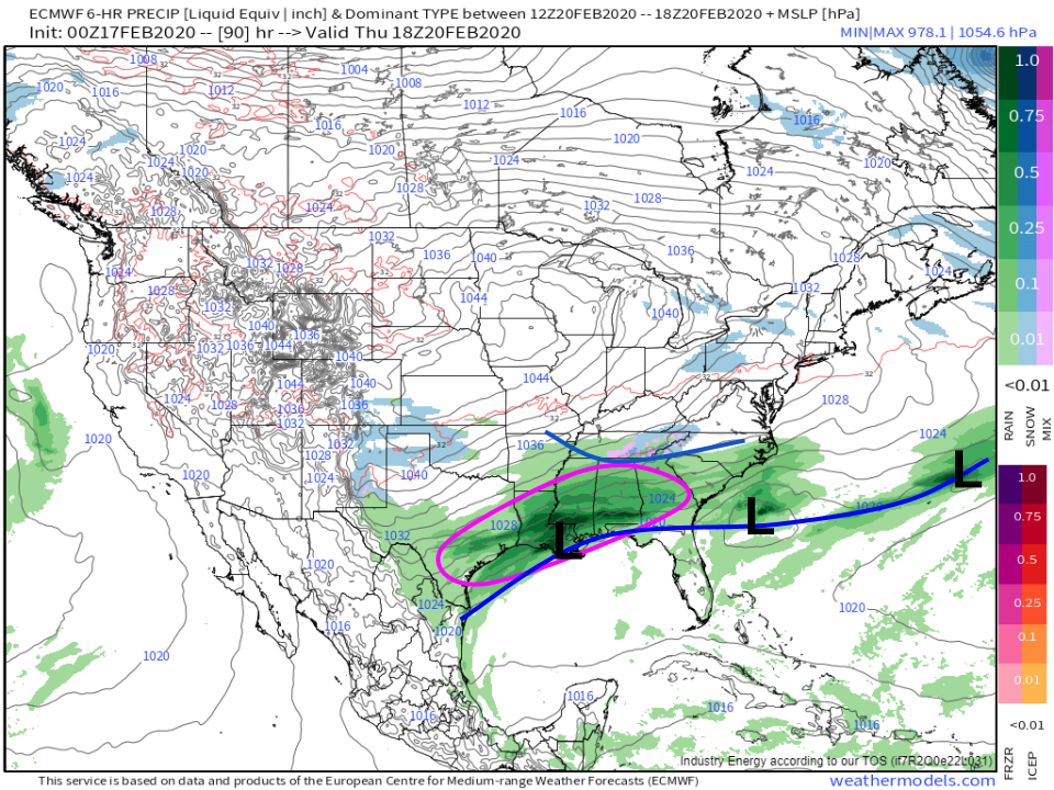
By Thursday, the next wave will be developing over Louisiana with another round of showers and storms over the same parts of the Lower Mississippi Valley. Rainfall totals with this wave look pretty similar to the first wave with a widespread 1-3″ and locally higher totals possible. One other thing to watch for as this wave moves east is the potential for some wintry precipitation in Tennessee as cold air moves south out of Canada ahead of a strong area of high pressure over Iowa. At this point, major winter weather impacts seem unlikely.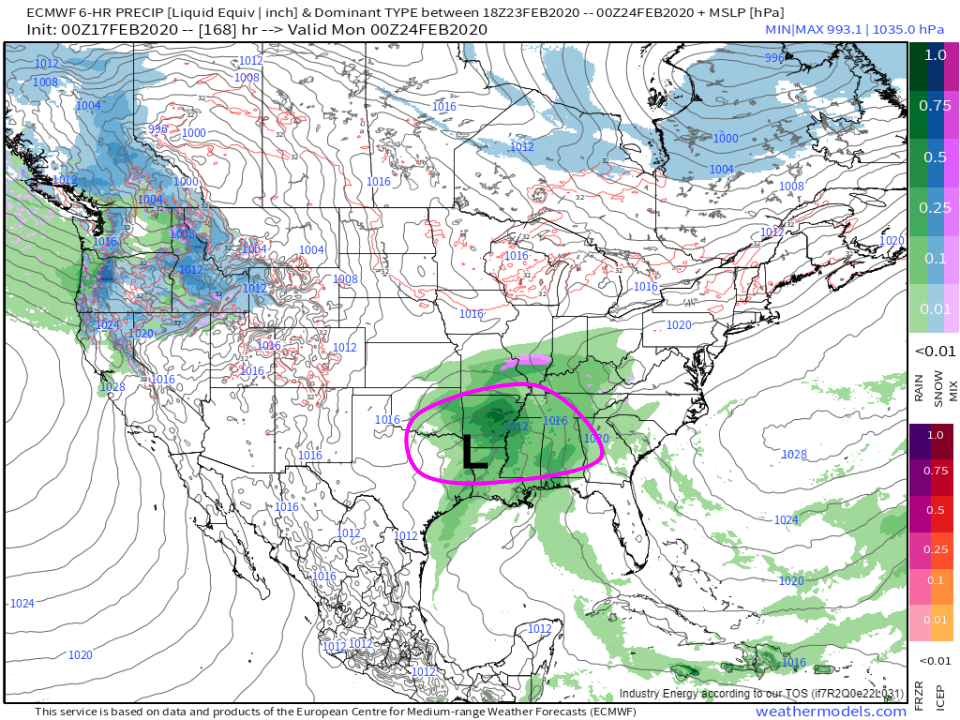
After Thursday’s wave departs on Friday, a day or so of dry weather is likely before the final wave (for now) arrives later in the coming weekend. This system will follow a track very similar to the previous systems, and while it’s too early to be very confident in how much rain will fall as this system moves east, early indications are that it will be comparable to the two waves from earlier in the week.
None of these events individually will be that impressive, but by early next week another 2-5″ will have fallen across most of the Deep South from Austin Texas to Charleston South Carolina. Locally higher totals will surely be observed where individual thunderstorms linger for a particularly long time. Ordinarily, this setup wouldn’t be cause for much concern but given the very moist antecedent conditions, additional flooding is expected alongside continued ongoing flooding.
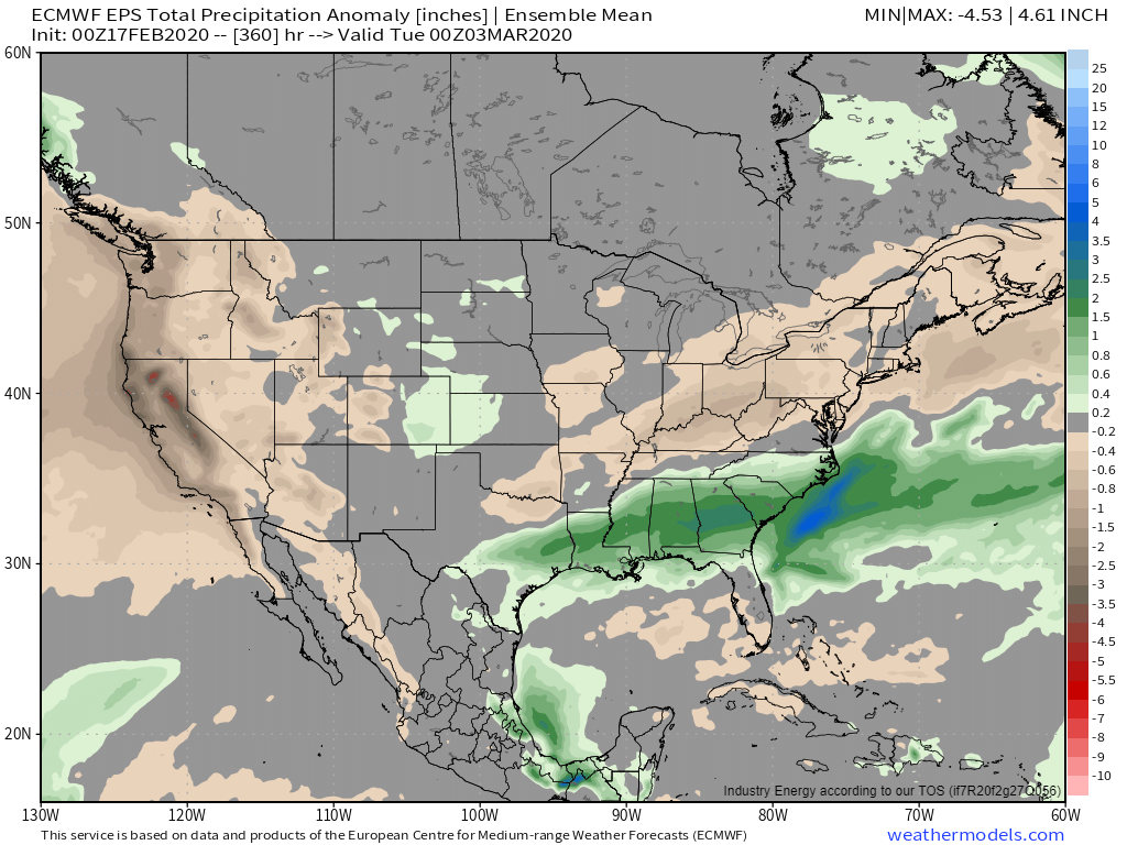
Peering even farther into the future, EPS 15 day guidance suggests that there’s no immediate end in sight to the wet pattern across the Southeast. Flooding may very well continue into March.
-Jack
