Week Of 4/29: No Shortage Of Thunderstorms In The Plains, Generally Quiet Elsewhere
Hello everyone!
It’s a new week, and that of course means new weather. A pattern will emerge over the next few days that will fuel repeated rounds of strong to severe thunderstorms in the Great Plains, with an accompanying heavy rain threat. To the east, warm weather will be enjoyed south of a frontal boundary in the Mid Atlantic as well as across the southeastern states. Farther north, cool and damp weather will be found in the Northeast while more snow falls in the Rockies. The video embedded below will offer a slightly more in-depth rundown of the weather across the country over the next few days, while the severe weather threat will be discussed in further detail below.
General Overview Video
Southern Plains Storms Extended Discussion
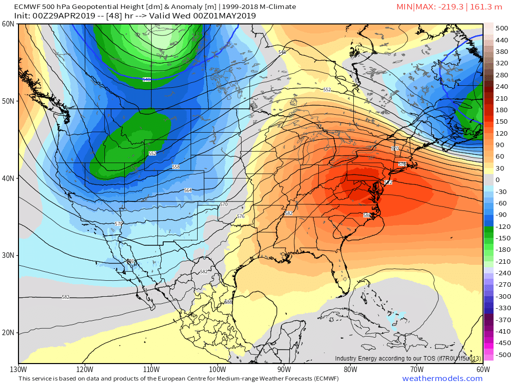
Featured product: ECMWF 500mb Heights/Anomalies, available with any weathermodels.com subscription.
The pattern this week will look something fairly similar to this, and will set the stage for the expected severe thunderstorms. A trough will be located in the intermountain west, with a ridge centered over the Southeastern states. Southwesterly flow aloft will prevail between the two over the Great Plains, with several disturbances embedded within that flow pattern. One of those disturbances can be seen Tuesday evening over Kansas as a kink in the geopotential height lines plotted on the map above.
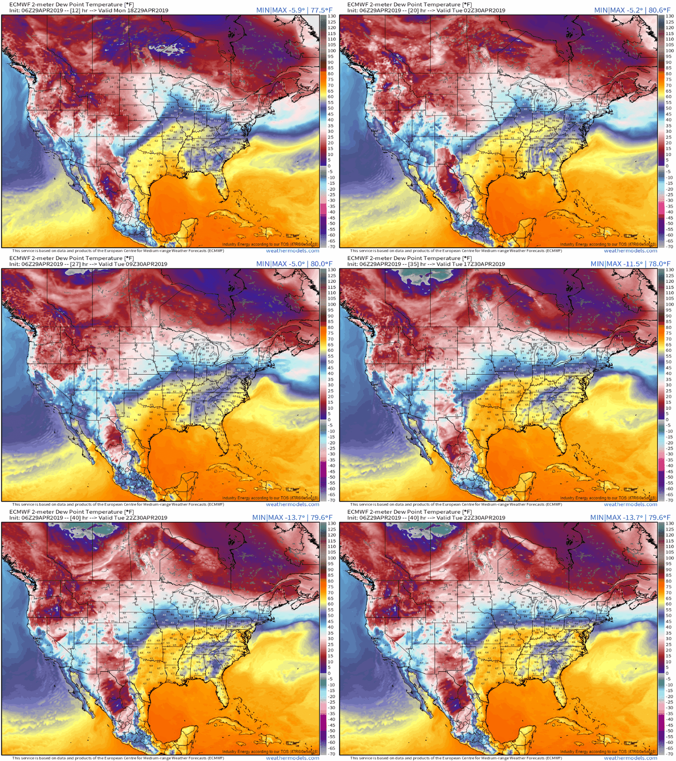
Featured Product: ECMWF Hourly Dew Points, available with any weathermodels.com subscription.
The large ridge shown on the upper level map will support a lower-level counterpart from Bermuda into the Southeast. Winds along the southern periphery of this high will bring tropical moisture through the Gulf of Mexico before making a turn north into the Plains. The ECMWF’s hourly dew point forecast highlights this moisture advection process well. This moisture will help provide fuel for the storms in the form of convective instability (which can be visualized with the CAPE parameter).
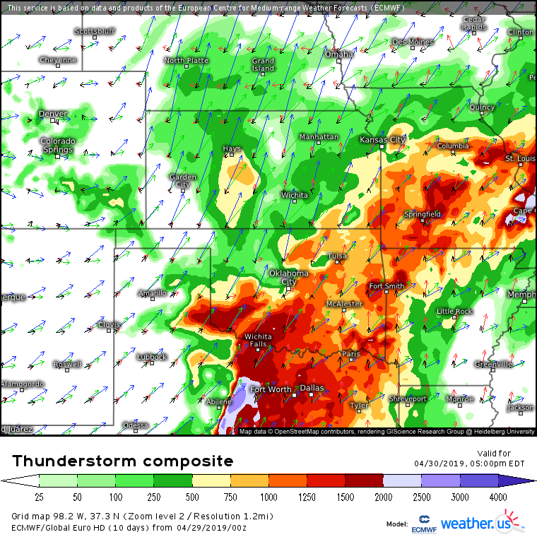
Featured Product: ECMWF Thunderstorm Composite, available free from weather.us. (click here for tutorial video)
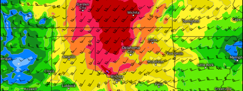
The greatest severe storm risk will be found across NE OK, SE KS, and SW MO tomorrow evening. The ECMWF’s thunderstorm composite map lets us take a closer look at the dynamics behind the severe setup. First, note the lengthening of the blue arrows over W KS/NE. This is a 300mb jet streak, and air will be rising in its right entrance region over the aforementioned severe risk area. A frontal boundary marks the northern edge of the instability (shaded parameter), and will help spark initial storm development. The black arrows show southerly surface winds, which will generally limit the tornado threat by reducing the amount of near-surface rotation accessible to storms. That said, strong speed shear (increasing wind speeds with height) will make isolated tornadoes a possibility. The much greater threat though will be strong damaging winds and large hail.
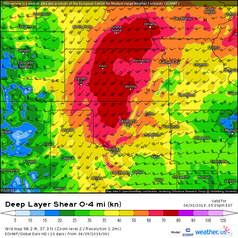
Featured Product: ECMWF Deep Layer Shear, available free at weather.us.
This map shows the deep layer shear vector, a rough guesstimate of how storms will move. Note that the shear vector is oriented parallel to the frontal boundary discussed above. This means that storms forming along the boundary will stay near the boundary, and thus will be in close proximity to other developing storms. The net result will likely be a line of storms as opposed to discrete supercells. The linear storm structure will magnify the damaging wind threat while further reducing the threat of long-lived tornadoes (though brief but equally dangerous spinup circulations are possible along the leading edge of the line).
Featured product: ECMWF 500mb Heights/Anomalies, available with any weathermodels.com subscription.
As the disturbance that powered Tuesday’s storms moves into the Great Lakes, ridging will return to the Plains on Thursday along with weaker upper level winds. This means that while storms will form during the afternoon hours due to daytime heating, they won’t be particularly organized. Isolated severe weather will remain possible as we move into the later part of the week, but the threat will be greatly diminished relative to the earlier week setups.
Looking to stay on top of the storms as they develop? Check out this video which shows you how to use the tools we have at weather.us to follow along with severe weather.
-Jack
