Week Of 4/22: Texas Thunderstorms Slowly Spread East, Chasing Out A Late-Season East Coast Storm
Hello everyone!
With no major weather events in the near future, I wanted to shift towards a discussion of the week’s weather in more general terms. The video below is a brief discussion of some of the larger scale patterns and features to note across the US between now and Friday. The more interesting features will be explained in a bit more detail below, so if you’re looking for a more in-depth take on the severe thunderstorms expected across parts of the South, that’s the place to go.
General Discussion Video
Texas Severe Weather Extended Discussion
The most impactful weather this week will come in the form of severe thunderstorms mostly confined to the state of Texas. The storm threat will begin this evening across western parts of the state near Lubbock and Abilene before shifting southeast tomorrow and Wednesday.
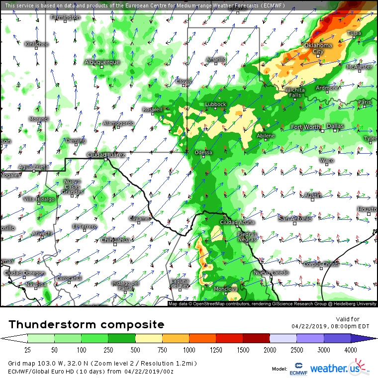
Featured Product: ECMWF Thunderstorm Composite, free from weather.us (tutorial video here)
The ECMWF’s Thunderstorm Composite map shows an environment moderately favorable for severe thunderstorms this evening NW of Abilene. The yellow shading highlights areas where instability will be just robust enough to support strong to severe storms, while the wind vectors highlight winds at different altitudes. A surface boundary (dryline) marks the western extent of the unstable air, extending from Roswell NM down into northern Mexico. That boundary will serve as the focal point for severe thunderstorm development this evening. With upper level winds oriented roughly perpendicular to that boundary, expect storms to begin as discrete cells capable of damaging winds, large hail, and a brief tornado before evolving into a more linear system later this evening where damaging winds will be the primary threat.
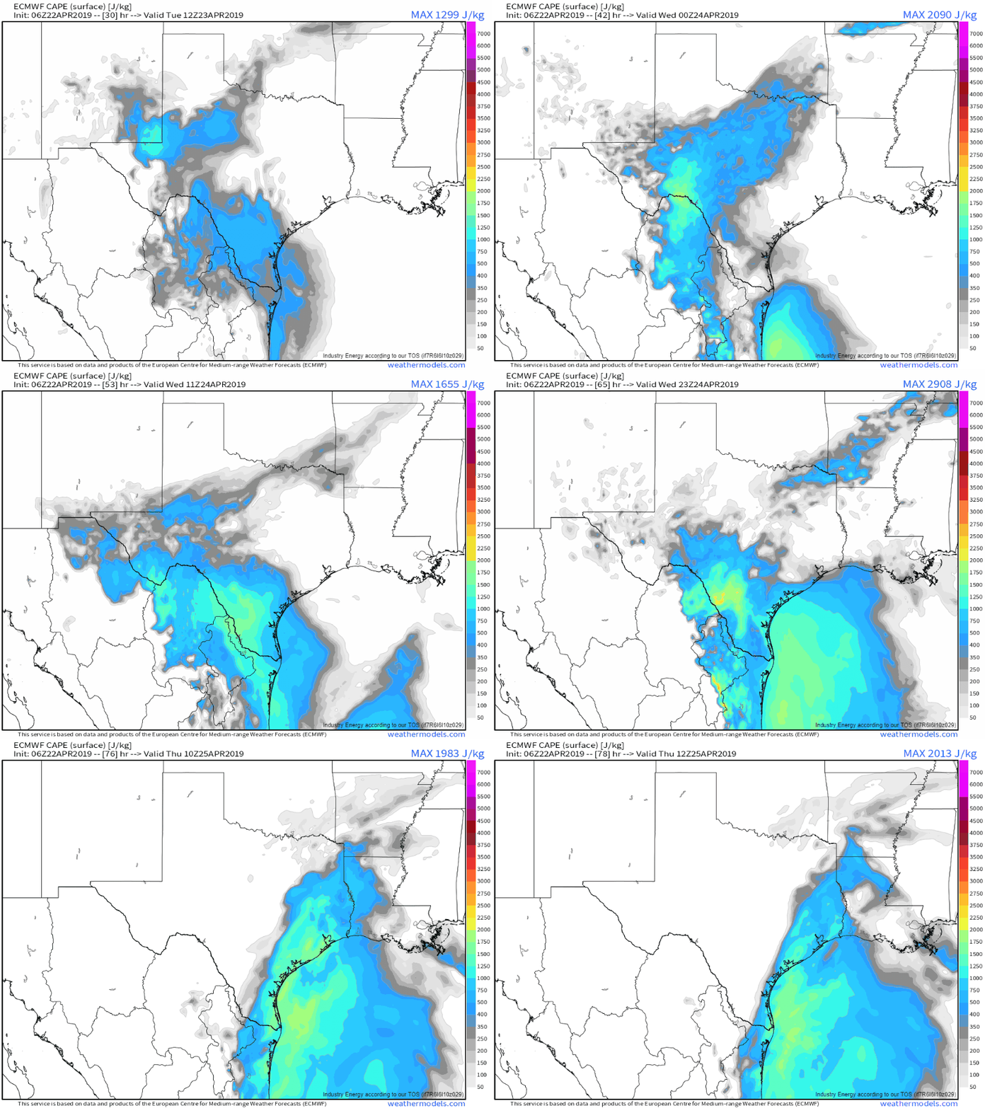
Featured Product: ECMWF hourly CAPE forecast, available with any weathermodels.com subscription (tutorial on CAPE here)
The ECMWF’s CAPE forecast for the next few days shows unstable air slowly drifting towards the southeast as low pressure develops near Dallas. As the cooler and drier air moves southeastward, severe storms will be a threat on the leading edge of the new airmass. Tuesday’s storms will be most numerous between Dallas, San Antonio, and San Angelo. Much like today, shear profiles will be set up in a way that initially favors supercells, before a later transition to more linear storm structures. The most instability will arrive over SE TX on Wednesday, and will support some of the strongest storms this week.
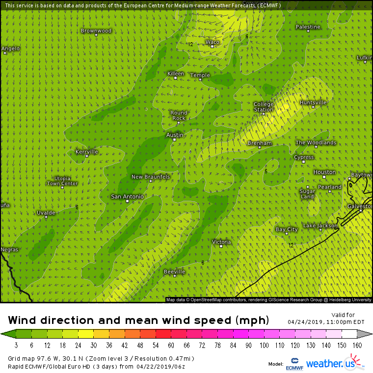
Featured Product: Rapid ECMWF 10m winds, available with weather.us extra features subscription
Wind forecast from the 6z ECMWF (rapid) run show steady NW flow developing over Central TX by Wednesday evening. This will contribute to stronger forcing for ascent along the cold frontal boundary, which in turn will drive a more organized line of storms towards the Texas coast. The main threat with these storms will be strong straight-line winds, though these lines of storms are also known for spinning up brief but dangerous tornadoes on their leading edges. The wind shear provided by southeasterly surface winds ahead of the front, and southwesterly winds aloft will contribute to this front-end tornado threat, which will impact places like Houston well after sunset. Make sure if you live in SE TX that you have a way of receiving warnings should they be issued for your area, even if you’re asleep! Also make sure you know ahead of time what to do if a warning is issued
Featured product: ECMWF 500mb Vorticity, available with any weathermodels.com subscription
The upper level storm system driving the severe weather in Texas during the first half of the week will slowly unravel as it moves towards the Mississippi River on Thursday. That doesn’t mean the severe threat will disappear entirely, but it will mean that another widespread outbreak like we saw last week is very unlikely.
Stay on top of the storms all week with the tools we have at weather.us including HD radar imagery, GOES-East satellite imagery, and lightning analysis data. Not sure exactly what you’re looking at? Check out this tutorial video where I explain how to follow along with severe storms using these tools.
Looking for your local forecast? Weather.us has you covered with a variety of tools for staying on top of your local weather. Not sure where to start? I have a whole series of tutorial videos over on our Youtube page to put you on the right track. Things still unclear? Send me an email jack@weather.us and I’ll see if I can help clear things up.
I’ll have my next post here on Thursday discussing the weekend forecast. In the meantime, follow us on twitter @WeatherdotUS @RyanMaue and @JackSillin for more frequent updates in the next few days.
-Jack


