Watching Two Tropical Systems This Weekend
Hello everyone!
We’re carefully watching the progress of two tropical systems in the tropical Atlantic this morning. The first, currently located east of Florida, has already been discussed here on the blog back on Friday. This post will provide some quick updates to the information presented there. If you’re looking for a more detailed analysis of the environment and factors contributing to that system’s eventual track, please read back to the previous post. The second storm has been named Dorian by the National Hurricane Center after it developed a closed center of circulation and maximum sustained winds of 40 mph. Dorian is located several hundred miles ESE of Barbados, and is still several days away from potentially impacting US interests in Puerto Rico. This post will go into more detail on Dorian and its future given that I haven’t discussed it already.
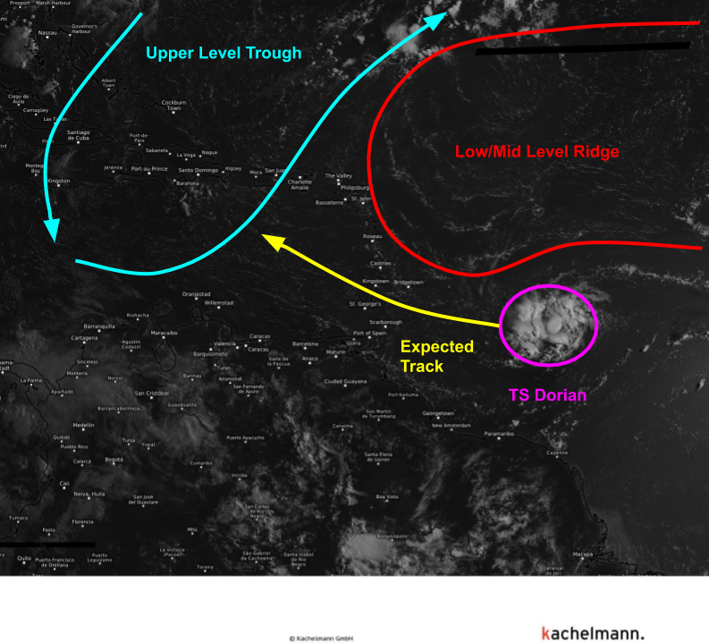
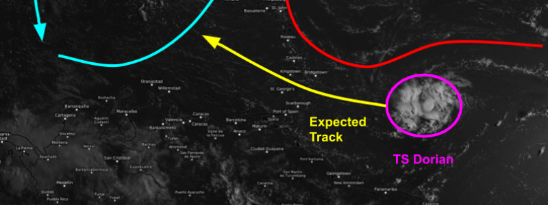
Tropical Storm Dorian is currently a small storm ESE of Barbados, visible on GOES-East satellite imagery shown above. The storm is located south of a ridge of high pressure in the low/mid levels, which is steering the storm on a westerly track. A shift in track towards the WNW will occur as the storm approaches the western side of that ridge around the longitude of the Lesser Antilles. An upper level trough is visible farther west over Hispaniola. That feature will become more important to Dorian’s future once it moves through the islands, and will be discussed later. From an organizational perspective, Dorian is looking ok this morning with a developing spiral band and some thunderstorm activity near its center. Dry air is hindering development somewhat by killing off the thunderstorms closer to the edge of the circulation, especially on the eastern side.
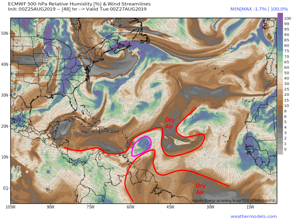
The dry air is visible on forecast 500mb relative humidity maps. Dorian is currently occupying a small envelope (pink circle) of moister air amidst an expanse of dry air that stretches across nearly the entire Atlantic Basin from the Yucatan Peninsula over to the Azores. That dry air will continue to be a struggle for Dorian unless it can build a sufficiently resilient ring of thunderstorms which can prevent that dry air from getting too entrained in the circulation. Map via weathermodels.com.
Wind shear is another factor that can inhibit the development of a tropical system by stretching thunderstorms horizontally until they fall apart. Currently, Dorian is enjoying a pocket of relatively light wind shear under an area of upper level high pressure. This favorable environment won’t last after the storm moves through the islands due to the upper level trough mentioned above.
The ECMWF’s wind shear forecast shows a long area of strong westerly shear running into Dorian on Wednesday morning. That shear is caused by strong westerly winds in the upper levels out ahead of an elongated upper level trough (marked in blue on the map above). Those strong winds will also help push dry air into the core of the system, which will be another factor pushing the storm to weaken once it enters the Eastern Caribbean. Overall, while some strengthening is possible over the next 48-72 hours on approach to the islands, Dorian looks like a relatively short lived storm. Map via weathermodels.com.
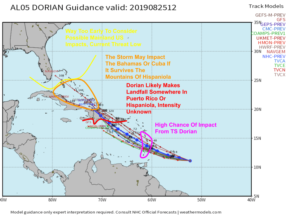
Here’s a look at some of the model guidance for the system. The official National Hurricane Center’s forecast is the thick blue line. The central Windward islands have a high chance of being impacted by Dorian early this week as it crosses the island chain as a moderately strong tropical storm. After that, the system will move into an unfavorable environment with higher wind shear and continued dry air over the Eastern Caribbean. This will likely weaken the storm back to a weak TS or TD (Tropical Depression) before it makes landfall either in Puerto Rico or Hispaniola. If it were to hit Puerto Rico, or sneak through the Mona Channel between the islands, it may emerge north of the Greater Antilles intact. However, the most likely scenario at the moment is that the storm moves inland over Hispaniola and gets torn apart by the island’s 10,000 foot mountains. The system would still pose a heavy rain/flash flood threat to the island regardless of its maximum wind speed on approach. If the storm were to make it past Hispaniola intact, it could bring some heavy rain and gusty winds to the Bahamas by the end of the week. At this point, the threat posed to the Mainland US by Dorian is very low. Even if the system were to make it to Florida in about 7-10 days, it would likely be barely more than a passing rain shower after facing the strong wind shear, dry mid level air, and the mountains of Hispaniola. We’ll keep an eye on the storm and any potential forecast changes, but at this point the only part of the US to face possible direct impacts from Dorian is Puerto Rico. Map via weathermodels.com.
What about that storm 98L off of Florida? It’s still there, and still not doing a whole lot in terms of developing into a tropical cyclone.
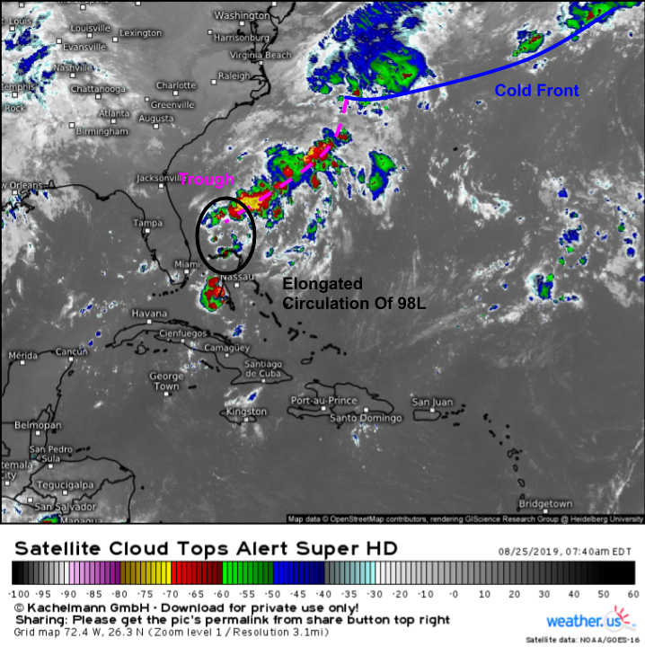
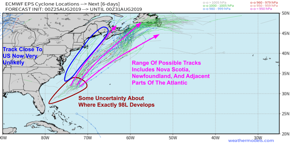
Morning satellite imagery of the system shows an elongated attempt at a center of circulation that’s getting tangled up in a frontal boundary that extends to the northeast of the system. A non-tropical area of low pressure located along this front east of Cape Hatteras has access to seasonably strong jet stream dynamics, and will develop into a seasonably strong ocean storm southeast of Nova Scotia over the next 3-4 days. This storm will open a path for 98L, or whatever tropical cyclone develops from it, to exit swiftly to the Northeast during the coming week. This is well-reflected in the EPS storm track map below.
There’s still some uncertainty regarding how long it might take for the system to untangle itself from the frontal boundary and organize into a tropical cyclone. Most EPS members forecast this process taking place on Monday or Tuesday as the system moves in between South Carolina and Bermuda. After that, the storm will be quickly ushered northeast towards the Canadian Maritimes. If you have interests in Nova Scotia or Newfoundland, you should be monitoring 98L’s progress closely. Given that the non-tropical storm forecast to develop over Nova Scotia has trended slightly stronger in recent guidance runs, a scenario where 98L tracked close enough to bring direct impacts (rain/wind) to the East Coast is now extremely unlikely. Map via weathermodels.com.
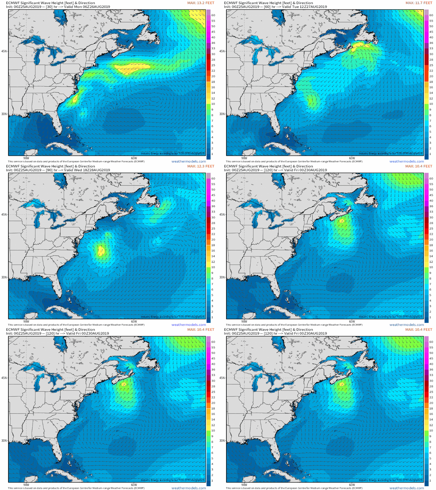
Instead, the storm’s impacts will come in the form of higher surf which will raise rip current risks at beaches from Florida to Maine. If the storm can strengthen a bit more than the ECMWF run above is showing, some beach erosion or minor coastal flooding is possible in the most vulnerable locations. GIF via weathermodels.com.
We’ll have more information on both Dorian and 98L here on the blog and on twitter @WeatherdotUS/@JackSillin.
-Jack
