Upper Level Low To Bring Showers And Storms To Parts Of Texas And The Lower Mississippi Valley
Hello everyone!
Quiet weather is ongoing across the country this morning, but that is expected to change this afternoon as an upper level low ejects east from Northern Mexico. As this low encounters Gulf of Mexico moisture, it will fuel showers and thunderstorms that are expected to develop across parts of Texas before moving east towards the Lower Mississippi valley.
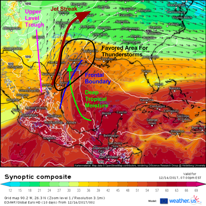
The ECMWF’s synoptic composite map (what’s that?) shows the setup behind the storms this afternoon/evening. An upper level trough is visible as a dip in the black lines which represent 500mb heights. Ahead of this trough, general rising motion is located over Texas. At 300mb, an area of strong winds is visible as a collection of larger vectors stretching from NE Mexico into the Plains. This jet streak is turning to the right (clockwise) meaning it is anticyclonically curved. The right entrance region of anticyclonically curved jet streaks is an area favored for strong upward motion, and SE Texas will be located under this entrance region today. A lower level jet (LLJ) will develop this afternoon extending from the Gulf of Mexico into the SE Texas area as air rushes to fill the void left by air parcels accelerating into the upper level jet streak. This LLJ will help to transport a rich moisture supply from the tropics. The final step is a surface boundary located right near the Texas coast. This boundary will help to focus thunderstorm activity as it slowly moves east to stay ahead of the upper level trough.
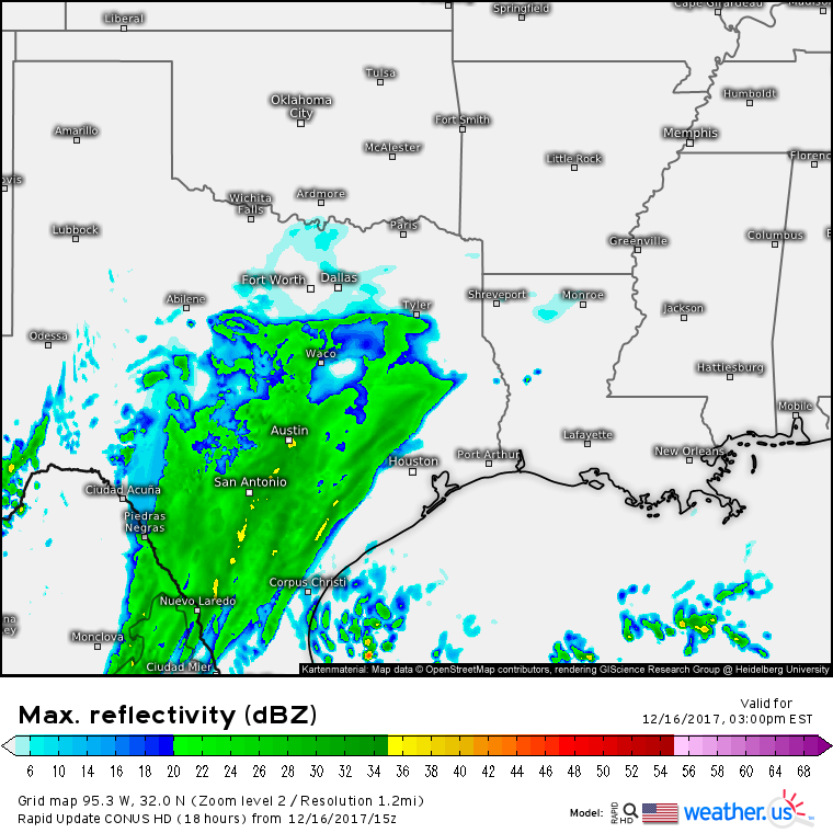
Rain will quickly expand northeast this afternoon as shown by the simulated radar image above. Due to cooler air on the NW side of the frontal boundary mentioned above, storms that develop today are unlikely to bring much if anything in the way of severe weather. The tropical moisture flowing up and over lower level cold air will produce a steadier, more widespread rainfall than what’s typically expected in this area.
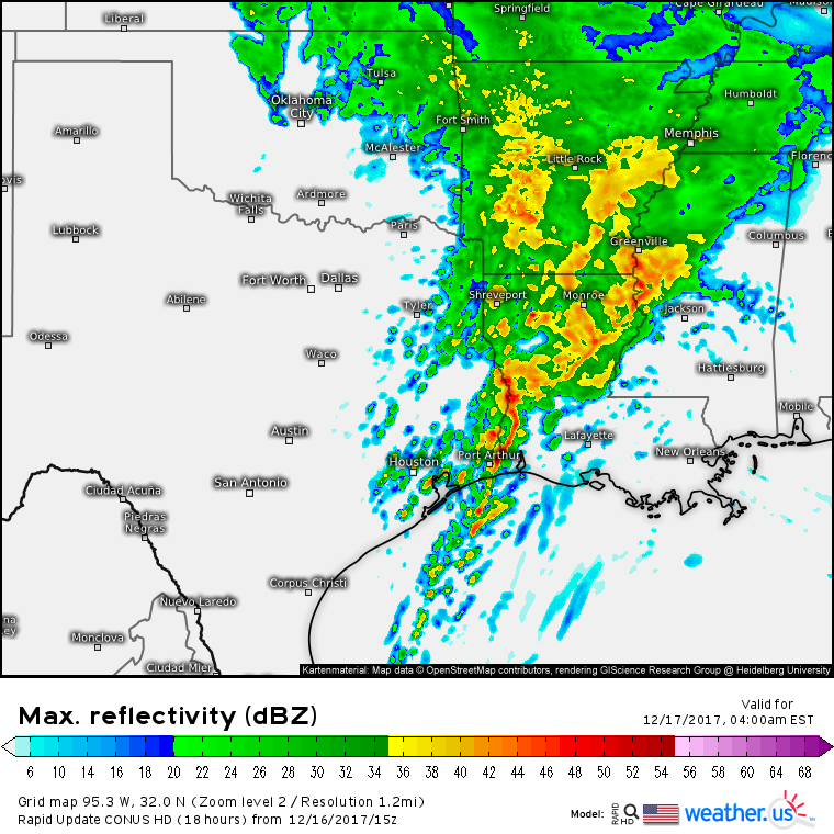
As the front moves ashore this evening, unstable air will move into the Houston area. This will allow for precipitation to shift towards a more convective mode, with localized bands of very heavy rain where thunderstorms “train” over the same areas repeatedly. 2-4″ of rain are possible in these localized areas. Much lighter totals will be expected outside of these bands, though there are enough large scale dynamics to ensure a solid soaking for just about everyone in SE Texas.
As we move into the early hours of tomorrow morning, the system will begin to shift eastward. Rain will be done for all but the far SE corner of Texas, and the core of the activity will be found in the Lower Mississippi valley from Arkansas down into Louisiana. A weak surface low may form along the front, and move into Louisiana. If that happens, some damaging wind gusts would be possible from Port Arthur Texas up towards Alexandria Louisiana. Otherwise, the severe threat is expected to remain fairly low.
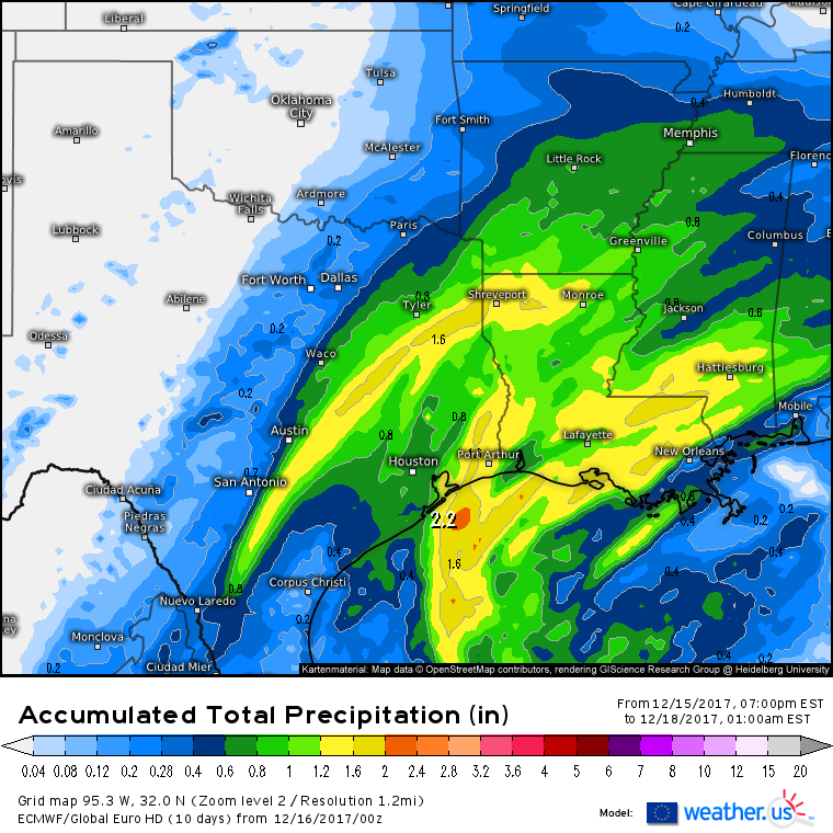
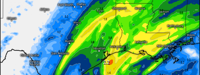
So how much rain is expected? Here’s the ECWMF’s total precipitation forecast for the event. The highest totals, as discussed above, will be found in localized bands across SE Texas where thunderstorms have the potential to train over the same areas. A general 1-2″ is likely for much of Louisiana, with lighter amounts to the north and east as thunderstorms weaken and fall apart tomorrow afternoon. Another band of heavier rain is expected well to the west of the surface front, extending from areas south of San Antonio up towards Shreveport. Up to an inch is expected in this band, driven by mid level dynamics. There’s still some uncertainty though as to where exactly it sets up. Amounts will drop off quickly to the west of San Antonio, as moisture won’t be able to get west of the jet streak/trough axis.
Track these storms this afternoon and tomorrow with our HD radar products: https://weather.us/radar-us/texas/reflectivity/KDFX.html#play click the map to zoom in, or click one of the small yellow rings to select a different radar that shows a different area.
-Jack
