Two More Tropical Systems In The Atlantic: Will They Pose US Threats?
Hello everyone!
Florence continues to be the main focus in the Atlantic today as it churns westward towards the Southeast US coast. For the latest updates on Florence, please consult the National Hurricane Center. If you’re looking for my thoughts on the system, yesterday’s blog provides a good summary. I will post an updated forecast at some point later today. That being said, this post will focus on two more tropical systems that have formed in the Atlantic: Tropical Depression 9, and Tropical Storm Helene. Both these systems are currently over the far Eastern Atlantic, but what is their forecast as they move west?
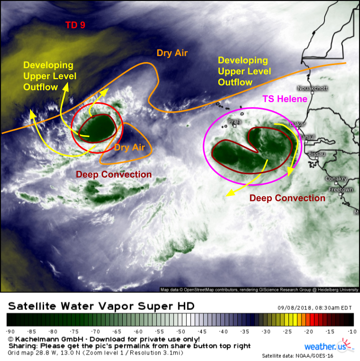
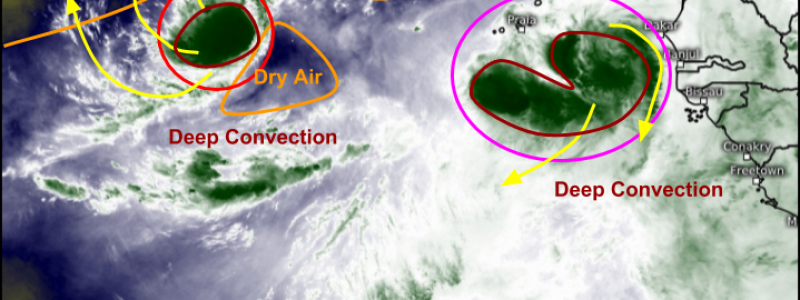
GOES-East WV satellite imagery (what’s that?) shows both TD 9 and TS Helene spinning over the Eastern Atlantic this morning. Helene is the stronger of the two systems, having attained Tropical Storm status. This is due in large part to the lack of dry air surrounding the system. Notice the two areas of dry air that are located close to TD 9. Dry air is damaging to tropical system because when it gets entrained into thunderstorm updrafts, it cools the air which makes it heavier. The heavier air then sinks, killing the storm. TD 9 has been struggling a bit with this, while Helene is embedded within an envelope of deep tropical moisture, and as is thriving as a result.
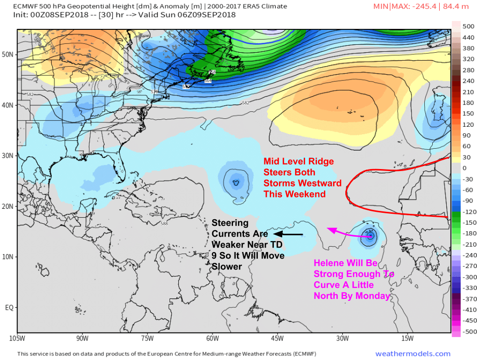
Short term forecasts for steering patterns surrounding the systems will establish generally westward motions for both TD 9 and Helene this weekend. The dominant steering influence will be a mid level ridge to the north of Helene. TD 9 will be farther away from this ridge, so steering currents will be weaker in its vicinity. This will lead to a slower overall movement for the system.
Map via weathermodels.com.
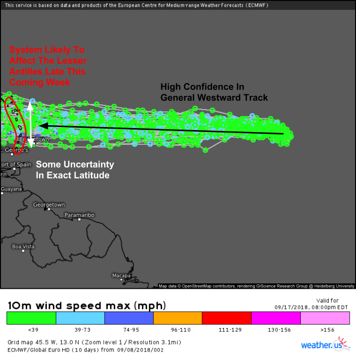
Here’s what the EPS (Ensemble Prediction System) thinks of TD 9’s track (what are EPS forecasts and how do I make sense of them?). There is very high confidence in the storm’s overall westward movement, but some uncertainty as to the exact latitude at which that westerly movement will occur. This means that while the system will affect the Lesser Antilles about five days from now, it’s too soon to say exactly which islands might be most impacted. It’s also too soon to say how strong the storm might be when it does arrive in the islands, with current estimates ranging from a weak tropical storm, to potentially a hurricane. The intensity forecast for TD-9 will largely depend on how it interacts with the dry air mentioned above. Ocean temperatures under the system will be warm, and as we’ll see in a minute, shear will be low as it moves west.
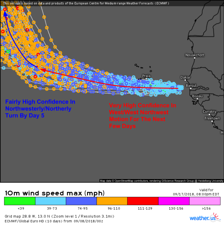
Meanwhile for Helene, westward motion is also expected over the next five days or so due to the mid level ridge discussed above. Helene will be strengthening as it moves west, as shown by the EPS forecast above. As it strengthens, it will curve a little towards the north, as stronger storms tend to get “pulled” towards the poles. While TD-9 is still five days away from impacting any land, the islands of Cabo Verde will see impacts from Helene. The southern islands should expect heavy rains, and gusty winds likely over tropical storm force as the system passes by tomorrow.
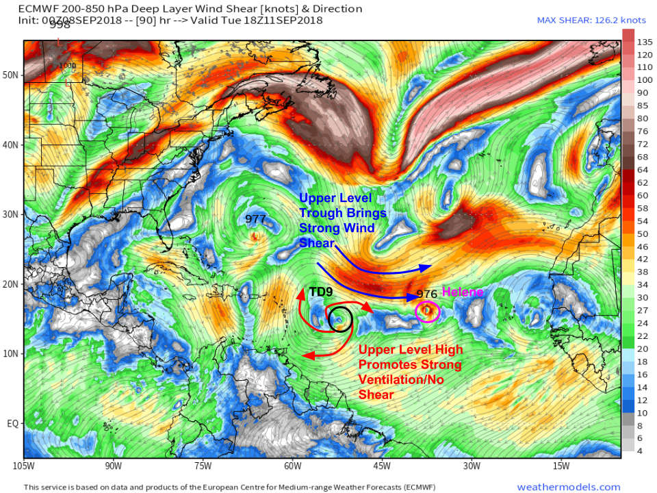
Here’s a look at the shear forecast for day five (Tuesday) according to the ECMWF model. Note that while Helene is the stronger system now, that may not be the case by the middle of next week. An approaching upper level trough will be increasing wind shear over the system, and that shear could be pretty intense (>40kts is the type of shear that can shred a tropical cyclone, even a well established one). TD 9 on the other hand will be located under an upper level anticyclone (area of high pressure). Air spiraling away from the center of that high pressure will help vent TD 9, which will likely be either Tropical Storm or Hurricane Isaac by that point. TD 9 will also be located over warmer waters, which will further assist its development.
Map via weathermodels.com.
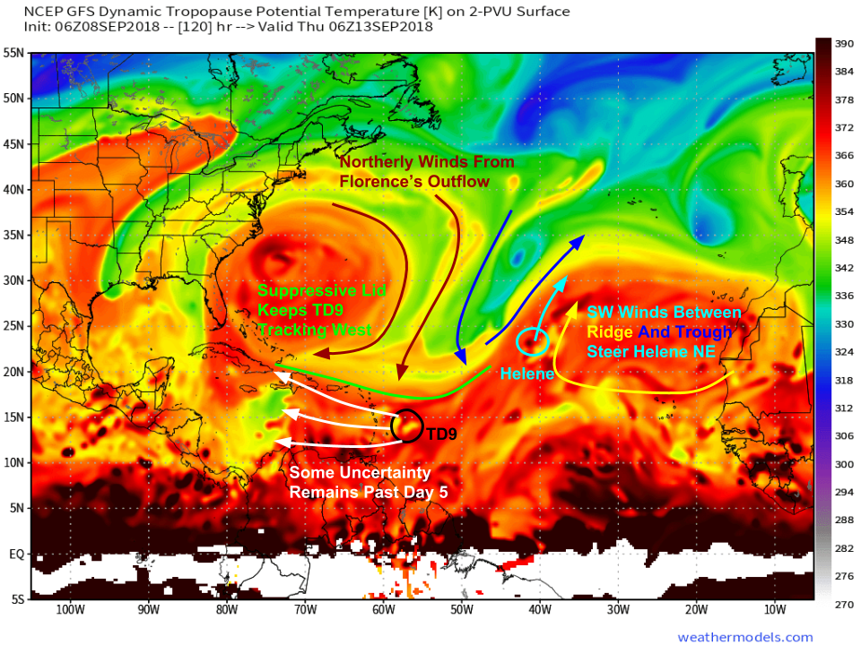
What about the long term forecast for TD 9 and Helene? This upper level map from the GFS highlights the general steering pattern next week. Helene is very likely to recurve out to sea as an upper level trough drops in to the west of the storm (that’s the same trough bringing shear to the system). TD 9’s track forecast will be influenced primarily by northerly winds from Florence’s upper level outflow. Those northerly winds will establish a “lid” of sorts that will keep TD 9 from gaining much latitude (unless it becomes a strong hurricane before the Lesser Antilles, in which case it would curve a bit farther to the north). While track uncertainties exist past day five, the general idea is that the storm will move through the Caribbean, likely while weakening a bit. Any possible threat to US interests from TD 9, past potential impacts to Puerto Rico in about a week, would be in the very long range period, and are highly uncertain. We’ll keep an eye on the storm for sure, but it’s way too early to worry about it very much. We have Florence for that!
Map via weathermodels.com.
Use GOES-East satellite imagery to keep tabs on these systems in real time over the next few days as they drift to the west.
My Florence update will be out later today. If you’re interested in the latest official Florence information, please consult the National Hurricane Center. If you’re interested in my thoughts on the system, yesterday’s blog post provides a good overview. If you’re interested in today’s flash flood setup across the Ohio Valley, please consult my blog post from earlier this morning, as well as local NWS offices for official forecasts and warning information.
-Jack
