Tropical Wave 98L Likely To Develop As It Moves North Off The Florida Coast
Hello everyone!
We’re closely watching a tropical wave located east of Florida for possible development as it moves north over the next few days. The system is showing some signs of organization this morning and the environment in its path is favorable for tropical cyclone development. This post will outline how the system is expected to develop, where it might track, and what its impacts will be for locations up and down the East Coast.
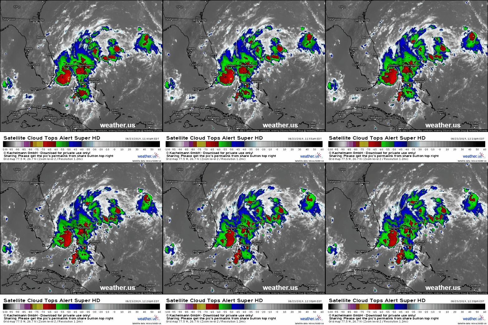
The storm is currently poorly organized as it meanders slowly NNW through the gap between Florida and the Bahamas. The storm doesn’t yet have a center, but the most persistent thunderstorm activity has been located between Miami and Nassau during the past few hours. Should these thunderstorms continue to develop over the same area, they’ll lift enough mass from the low levels to the top of the atmosphere to produce an area of low pressure at the surface which will become the center of the storm. This is a slow process that’s likely to continue over the next 2-3 days. Other features to note in the satellite loop include a developing spiral band farther south in the Bahamas as well as a developing outflow channel to the north (note the wispy cirrus clouds spreading out in that direction. Some dry air is present to the south and west of the storm, but the development of thunderstorms east of Key West in that southwestern quadrant suggests that the effects of that dry air will likely be minimal.
What does 98L’s future look like?
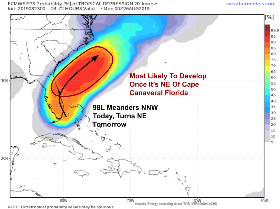
The near term future of 98L is fairly benign. It will remain disorganized as it drifts NNW towards the Florida Coast today and tonight. Florida can expect showers and thunderstorms to continue increasing in coverage during that time with heavy rain and lightning being the primary threats. Some gusty winds and waterspouts are possible with the stronger cells though the overall severe threat is on the lower side given a lack of strong winds in the mid/upper levels. Any development of the system into a tropical cyclone, if that does end up happening, will likely wait until Saturday or Sunday when the storm begins moving northeast. Map via weathermodels.com.
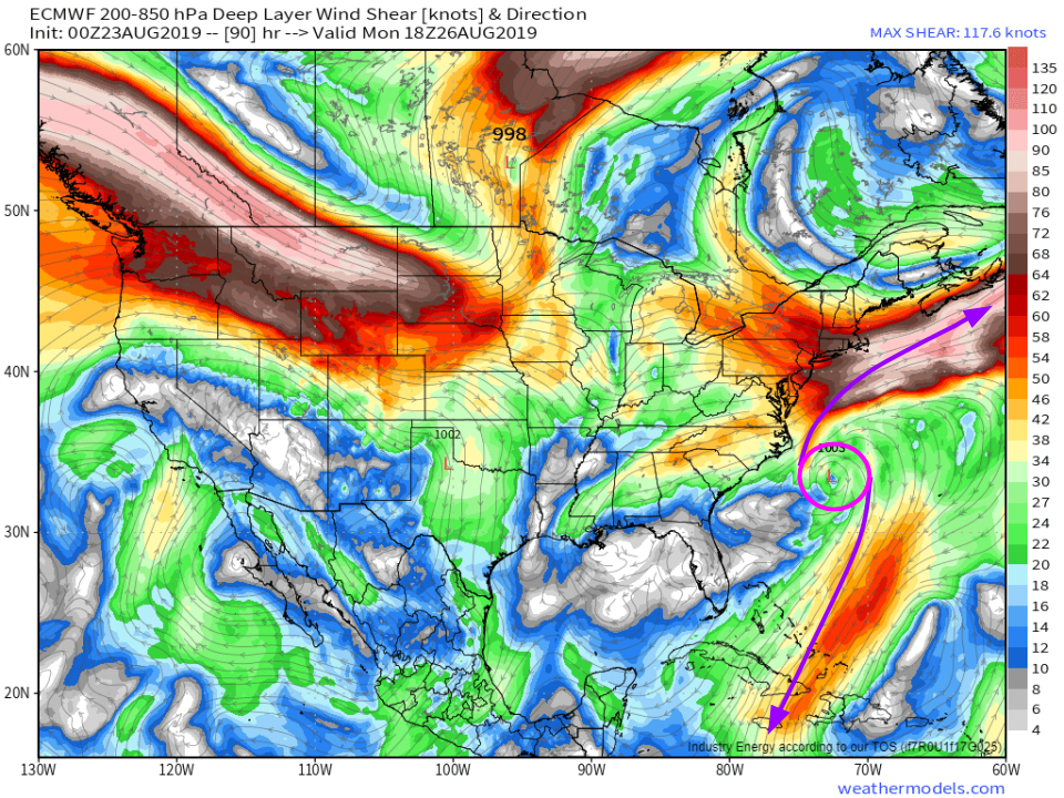
During that time, the environment will be favorable for intensification. The Gulf Stream will provide the warm water needed to fuel the system, and the map above shows an upper level wind pattern set up to vent air away from the storm’s center. That’s important because without the ventilation, the air rising upwards in the thunderstorms would pile up at the top of the atmosphere before eventually sinking back down. That sinking motion would then shut down the thunderstorms, and the system wouldn’t be able to continue developing. In the case of 98L, there will be jet streaks located both to the north and south of the system. These will help establish two pathways for the air rising at the center of the storm to race away where it can sink without impacting the storm’s development. Map via weathermodels.com.
Dry air is another factor to watch for. If dry air gets entrained into the system, it can cause problems as evaporating water droplets cool the air in the thunderstorms’ updrafts. That cool air is heavy and sinks, which means that thunderstorms have a hard time sustaining themselves. 98L will initially be relatively free of dry air issues, but after the storm passes Cape Hatteras, it will encounter a large area of dry air associated with a trough over the Northeast. This may help limit how much the system can intensify, but if the storm can build a strong enough core by that time, it won’t be affected nearly as much. GIF via weathermodels.com.
The bottom line is that after the storm leaves Florida, it will be positioned favorably to intensify into a tropical storm or potentially even a hurricane. After it passes Hatteras, where might the storm go?
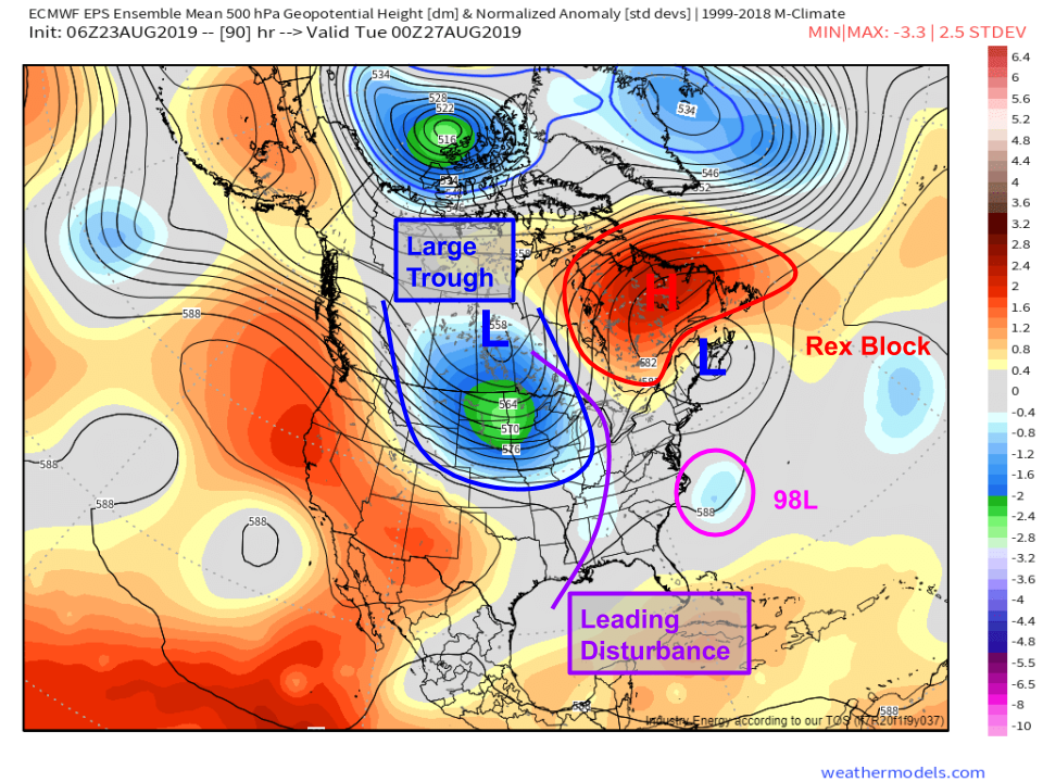
Most of the features important to answering that question can be found here. 98L will be steered by a combination of two features: a large trough developing over the Northern Plains and a Rex Block (high pressure north of low pressure) developing over NE Canada. Just how strong those two features are and where exactly they set up will be crucially important to determining where exactly the storm will go. As currently forecast, the storm should be able to escape out to sea ahead of the incoming trough. However, if that trough is slower or if the low pressure system near Nova Scotia is weaker and the ridge north of it ends up stronger, the storm may pass closer to the New England coastline. Map via weathermodels.com.
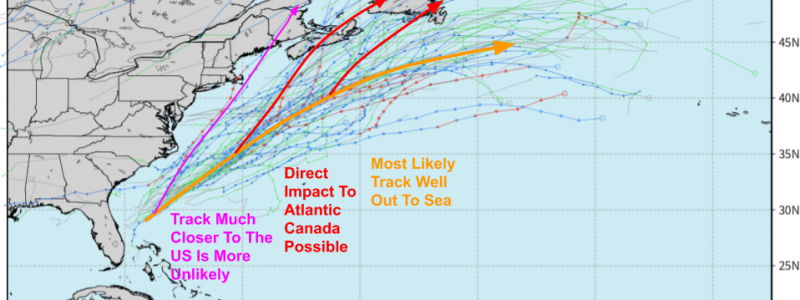
The range of possible outcomes and their relative likelihood is demonstrated well by the EPS cyclone tracks map above. Most of the members take the storm well out to sea without directly impacting land. There is a chance that the storm turns back to the north as it nears Cape Cod’s latitude in response to the building ridge and incoming trough. In that case, Atlantic Canada would need to keep an eye out for potential heavy rain and wind impacts in addition to heavy surf. A more dangerous track farther west, brushing NC’s Outer Banks and Cape Cod with hazardous conditions, is possible but unlikely based on currently available information. Map via weathermodels.com.
If you’re reading this from the aforementioned parts of NC and New England, know that direct impacts from 98L are not currently expected, but are possible. No matter where you live, now is a great time to review your hurricane plan. Make sure you know what you’d do if 98L’s track were to shift farther west; if you don’t use your plan this week, there’s always another storm that will inevitably head your way at some point. Without a way to tell whether that storm is coming next week, next month, next year, or next decade, having a plan ready for whenever you need it is the best course of action. Need some help figuring out what that plan should include? The National Hurricane Center has plenty of good resources to get you started.
I’ll be posting more info on 98L both here and on twitter @WeatherdotUS/@JackSillin over the next few days. If you have interests along the Southeast or New England coastlines, it’s also a good idea to keep tabs on official NHC info at nhc.noaa.gov.
-Jack
