Tropical Storm Isaias Likely To Threaten The East Coast As A Hurricane This Weekend
Hello everyone!
Tropical Storm Isaias is now interacting with Hispaniola, a key inflection point in the forecast for the system. After attempting to form a low-level center of circulation south of the island last night, the storm is relocating under a cluster of intense thunderstorms that formed northeast of the center this morning. This means that the storm’s circulation won’t be substantially disrupted by the higher terrain of central Hispaniola. Now that the center is skirting up the island’s northern coastline, it is in a much better position to intensify as it heads into the southern Bahamas tonight and tomorrow. As a result, the storm is more likely to pose a serious threat to parts of the US East Coast. This post will outline the forecast for the system over the next five days as it approaches the Southeast US coastline then turns north and eventually northeast up towards New England. As always, there will be plenty of discussion of what we don’t know (still quite a bit) as well as what’s starting to come into better focus.
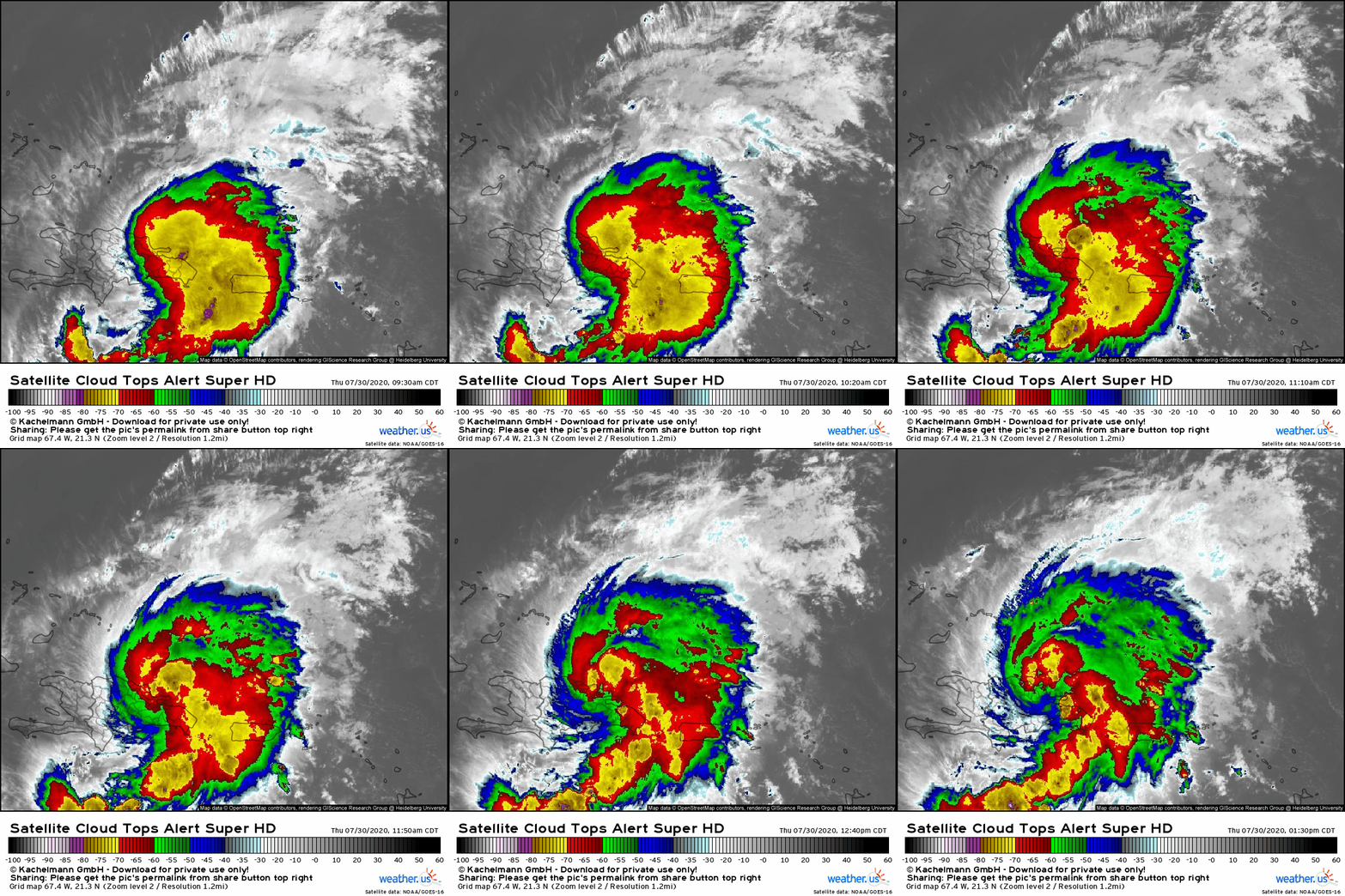
Satellite imagery shows a much healthier system today than in recent days, though perhaps not quite as robust as it was this morning. Intense thunderstorm activity is becoming consolidated around the system’s new center on the northern coastline of Hispaniola while spiral bands extend to the north and south of the center. Upper-level outflow is fanning away from the system in all directions suggesting that the storm is building an upper-level anticyclone even as it interacts with Hispaniola. The warming cloud tops (generally associated with weakening) are attributable to a combination of natural convective cycling in a developing storm, the time of day (tropical convection over water is most robust early in the morning and least robust late in the afternoon), and interaction with Hispaniola.
Water vapor satellite imagery provides a critical look at the storm’s structure and environment. Earlier this week, we spent a considerable amount of time discussing the role a Potential Vorticity Streamer (PVS) would play in Isaias’ forecast. Recall that you can think of a PVS streamer as a pool of cool/dry air in the upper levels of the atmosphere. The circulation around this feature will challenge Isaias with southwesterly shear and dry air intrusions over the next couple days. That said, Isaias is fighting back against this feature with its upper-level outflow. The air streaming away from Isaias’ core is quite warm (by upper-level standards anyway) and moist. Cirrus clouds serve as a useful proxy for tracking the movement of this air. Currently, we’re seeing cirrus clouds streaming westward ahead of the system. This is a signal that Isaias is building itself a protective envelope of higher moisture and lower shear through its outflow. The extent to which the storm can complete the task of building this envelope will be critical to its intensity as the system fights the PVS over the next couple days.
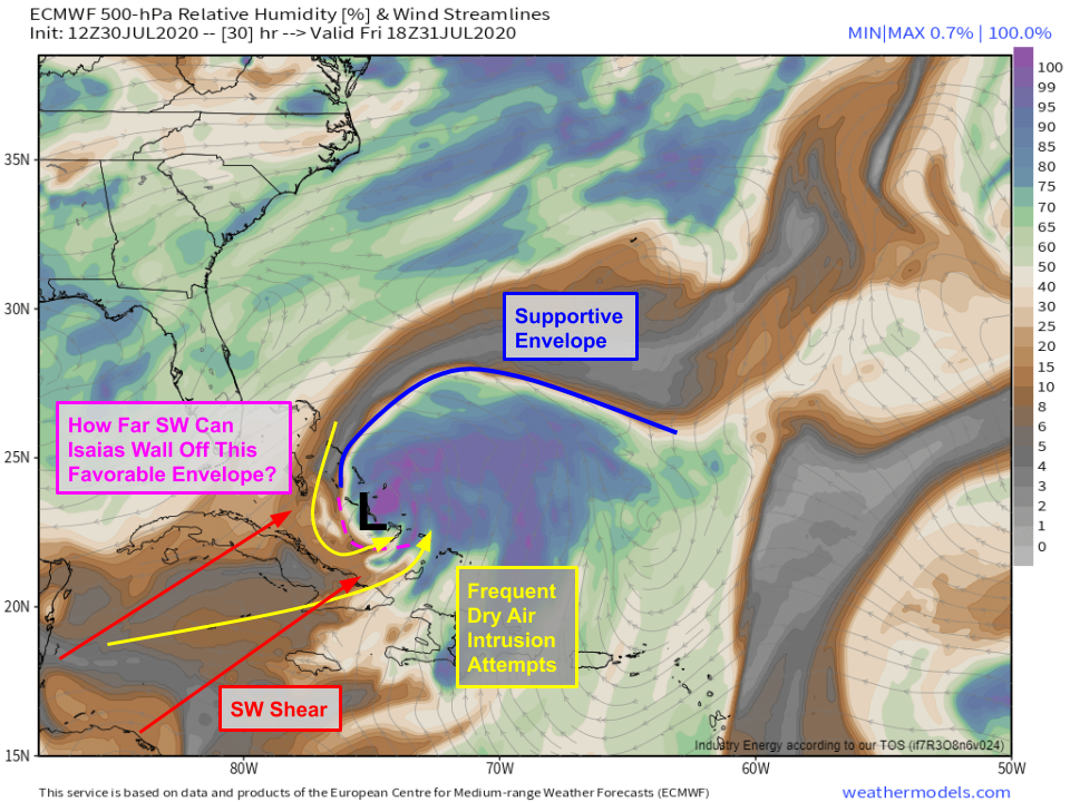 The PVS will mount its most serious challenge to Isaias tomorrow as the storm moves through the Bahamas as a strong tropical storm or low-end hurricane. The protective envelope mentioned above will be well-defined north and east (downshear) of the storm’s center, but how far upshear it’s able to wrap has yet to be determined. This will largely be a function of how much convection Isaias will be able to wrap upshear tonight and tomorrow morning. The more convection it has between its center and the dry air over Cuba, the better off it will be.
How well Isaias can defend itself from this PVS tomorrow is of course still an open question. I think the range of possible outcomes here is somewhere between weak TS (if it really struggles) and low-end category 1 hurricane (if it does really well). While it’s been done before, rapid intensification is hard to pull off in this much shear. Once you add that Isaias’ circulation will still be recovering from its dance with Hispaniola, I’m confident this won’t blow up into a major hurricane over the Bahamas tomorrow.
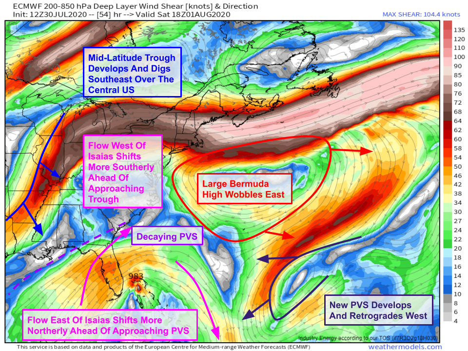 On Saturday, the upper-level environment over eastern North America and the western Atlantic will undergo some fairly dramatic changes as a trough digs into the central US. Ahead of that trough, upper-level winds west of Isaias will become more southerly. This will result in shear over the storm lessening. This in turn will help the storm rebuild its upper-level anticyclone. That process will be further assisted by a new PVS retrograding on the southern edge of the Bermuda high. Northerly flow on the western side of that feature will strengthen Isaias’ equatorward outflow channel, thus helping the storm recover from the shear tomorrow. As a result, I’d expect any weakening we see tomorrow to pause, and perhaps some re-intensification to begin on Saturday as the storm moves through the northern Bahamas where high-end tropical storm or low-end hurricane conditions are likely.
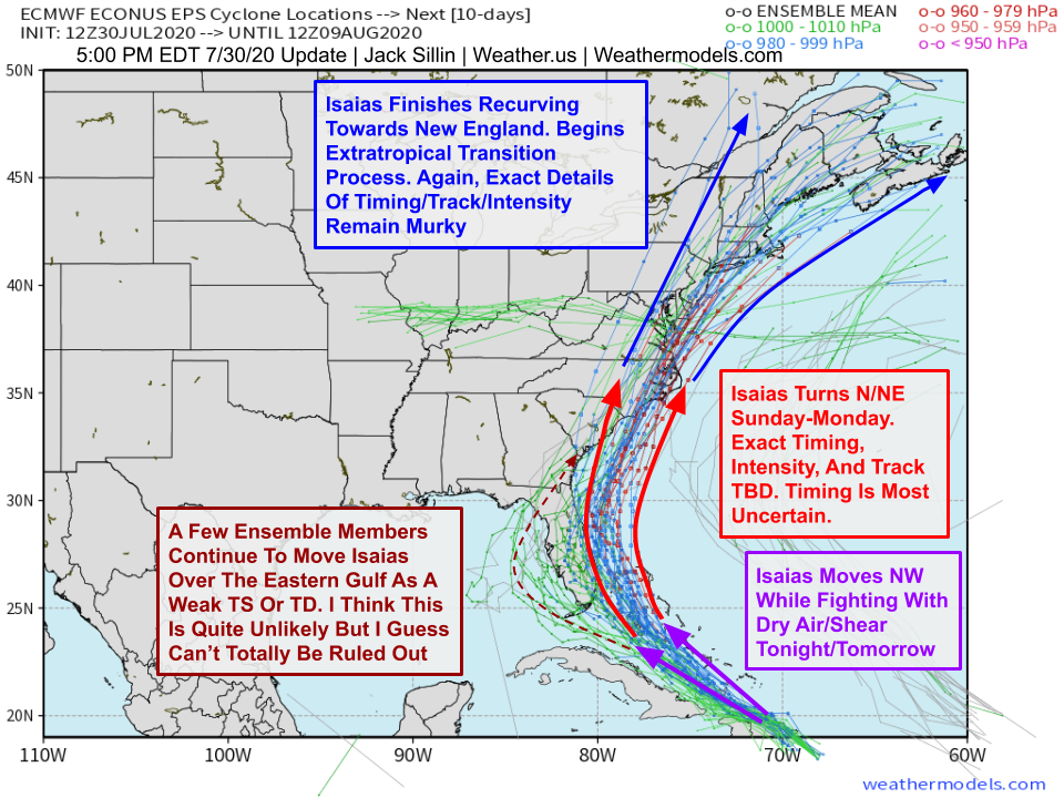
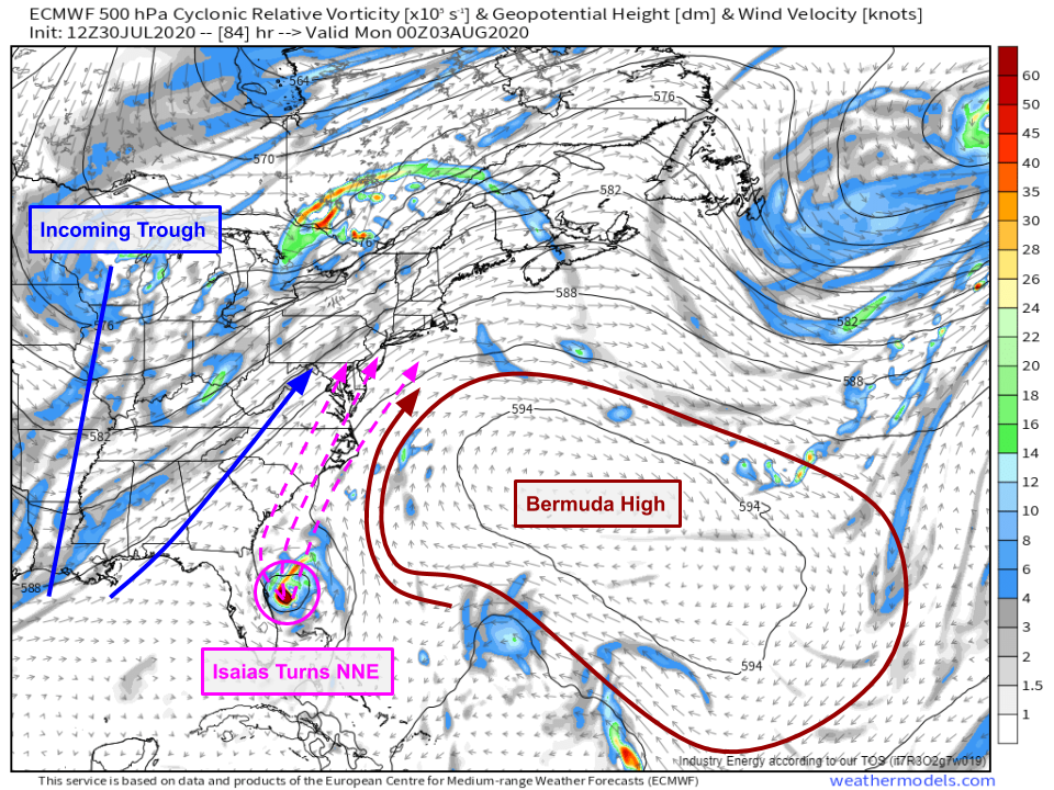 By Sunday, the Bermuda high will have tumbled east-northeast of Isaias (located somewhere near or east of Cape Canaveral) and the trough over the Central US will be swinging east across the Mississippi River. This leaves Isaias no choice but to turn north-northeast and accelerate. There are still small-scale track uncertainties to iron out that will be consequential for coastal residents. A track that wobbles farther west would bring gusty winds/heavy rain to a wider swath of the East Coast but the peak winds and surge wouldn’t be quite as intense (intensity limited by land interaction). A track farther east would lower the risk of impacts to the Southeast coastline but could make for a much stronger storm up in New England. There’s some chance the storm could even miss the East Coast altogether, sliding just far enough offshore to spare the worst impacts (though the usual capes (Canaveral, Hatteras, Cod) would still see some breezy showers).
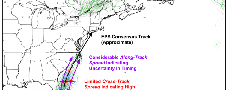
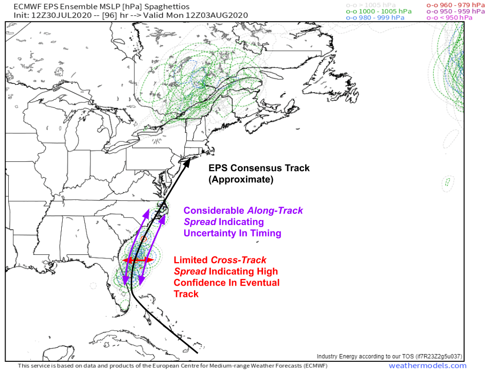 By Monday morning, we’ll still be dealing with two big forecast questions: how strong is Isaias and how far along its eventual track has it moved? EPS guidance shows considerable along-track spread which means that ensemble members all show the storm moving along a similar path, but some move the storm much more quickly than others. So even if we were to assume that a landfall in eastern NC is going to happen (definitely plausible, will come down to small-scale wobbles that are essentially random), there’s still the question of when. Some EPS members show this occurring as soon as Monday morning. Others wait until Tuesday evening. Some members show this landfall occurring as a mid-grade tropical storm, others as a major hurricane. As of now, I’ll split the difference and say I think the storm will make its closest approach to NC (landfall or no) sometime Monday afternoon as a low-end hurricane.
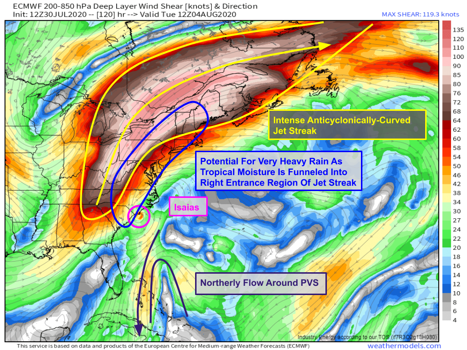 As Isaias moves near eastern NC (whenever that happens), its upper-level environment will give it another opportunity to intensify. The vast expanse of warm/moist air surging out the top of the storm will intensify the upper-level temperature gradient over southeastern Canada as the storm moves up the East Coast. As a result, an intense jet streak will develop around the western periphery of the Bermuda high. This jet will turbocharge Isaias’ outflow, a process accentuated by northerly flow around the PVS retrograding towards the Bahamas. With so much air racing in opposite directions near the top of the troposphere, Isaias will benefit from a strong upward motion response over its center. Additionally, it will also benefit from lifting associated with the right entrance region of the SE Canada jet streak. As moisture from Isaias is funneled into that jet and lifted by a series of processes associated with the right entrance region of strong anticyclonically-curved jet streaks such as this, expect heavy rain to develop well ahead of the cyclone center. This could cause serious flooding issues if that heavy rain materializes over land.
Remember that a wobble in Isaias’ track to the east would keep most of this over water, significantly lessening the associated impacts. That said, this basic recipe with the jet streak is one that I have fairly high confidence in given the general synoptic pattern. When you have a significant source of latent heat release on the southern end of a trough/ridge couplet like this, it will produce a jet response analagous to that shown here by the ECMWF. The remaining uncertainties are primarily related to the nuances of that process (how strong is it? how transient? where will it produce the heaviest rain? will the whole thing be shifted east or west from what’s currently shown? etc.) rather than whether it will occur or not.
So if Isaias were to brush the Outer Banks and continue towards New England (quite plausible based on currently available data), what might its intensity look like?
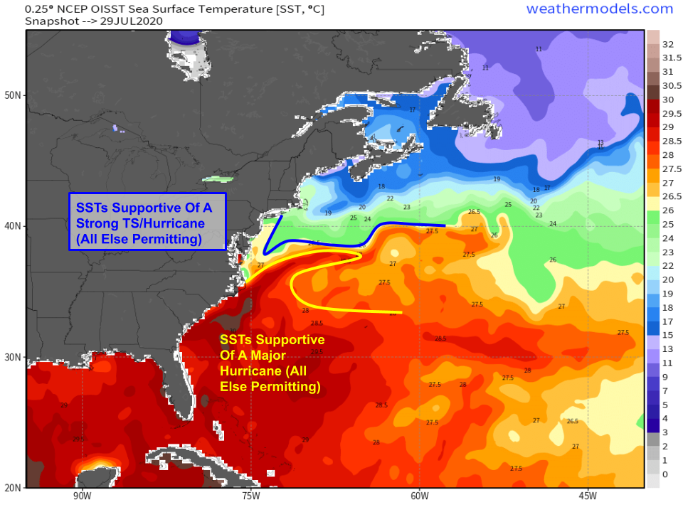
Normally, water temperatures are too chilly to support tropical cyclones north of the Outer Banks. This year however, this part of the Atlantic is running several degrees above normal. Therefore, this year water temps are warm enough to support a tropical cyclone of hurricane intensity all the way up to Long Island. Of course to get a hurricane landfall on Long Island from Isaias, we’d need plenty of other factors to come together. SSTs represent purely the upper limit of what a tropical cyclone could achieve if given perfect conditions. How much of that potential is realized depends on the storm’s structure, environmental shear, dry air, and other factors. Another factor that could let Isaias remain strong as it moves towards Long Island/New England is its fast forward motion. Tropical cyclones don’t instantly fall apart once they move over cool waters. That process takes some time, and if the cyclone is moving fast enough, the system won’t have time to weaken much before it arrives on land.
What’s the upshot of all this? Residents of the East Coast from Florida to Maine should be keeping a very close eye on forecasts over the next few days and should have their hurricane plans ready to implement if watches and warnings go up. There’s still some uncertainty regarding the exact track and intensity of Isaias, but it appears likely that impacts to the US of some magnitude will occur. Whether those impacts are serious flooding, damaging winds, and storm surge or breezy showers and some beach erosion has yet to be determined. Tomorrow’s blog post will hone in on impacts in more detail.
Here’s the latest annotated spaghetti map showing the range of plausible outcomes regarding Isaias. I wouldn’t be surprised to see the envelope of guidance shift a little bit more to the east, especially if the storm continues strengthening tonight and tomorrow.
If you’re in the Bahamas, a strong TS or hurricane is headed your way and you should be preparing appropriately. If you’re in FL, GA, or SC, you may very well be impacted directly by Isaias but it’s too early to say what exactly the magnitude of those impacts might be. Give it another day or so before watches go up to start preparing. Spend some time tonight reviewing your hurricane plan and making sure it’s up-to-date given the ongoing COVID situation. If you’re in NC or points north, know that substantial impacts from Isaias are very much in the cards early next week. Take some time tonight to review your hurricane plan and make sure you’re ready in case it becomes clear that the storm will head up the coast as a strong entity.
More details to come both here and on twitter in the coming days. In between updates from me, you can check forecast info yourself at weather.us and weathermodels.com. Especially useful in situations like this is our Forecast Ensemble tool which shows you the range of possible outcomes for winds/rain/etc. so you can see what’s most likely to happen as well as what reasonable best/worst case scenarios would look like. Best of all, it’s available for every town in the US no matter how small so you can always get info that’s locally relevant to your specific area.
-Jack
