Tropical Storm Dorian Approaching Barbados, Long Term Future Remains Uncertain
Hello everyone!
Tropical Storm Dorian continues to slowly strengthen as it moves WNW towards the island of Barbados this evening. It is currently fending off mid level dry air, and a favorable shear environment should allow continued strengthening during the next few days as the storm approaches the Greater Antilles. Its exact track through Hispaniola and/or Puerto Rico remains uncertain, and the storm’s long term viability depends largely on the extent of its interactions with the islands. Impacts to the Mainland US are possible next weekend, but currently there’s too much uncertainty to pin down the timing/extent of what those might be.
Farther north in the Tropical Atlantic, Tropical Depression 6 has formed between Miami and Bermuda. We’ll have an update on that system later this evening, but it will almost certainly avoid the Mainland US as it moves northeast this week.
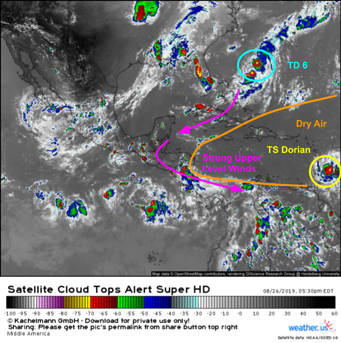
Both systems are visible in this satellite image from a little earlier this evening. TD 6 is trying to untangle itself from an elongated frontal boundary that stretches from near the storm’s center all the way up to a developing nor’easter south of Nova Scotia. The outflow from TD 6’s convection is feeding an upper level low over the Central Caribbean that’s bringing strong upper level winds to much of the Caribbean Sea. TS Dorian can be found at the far eastern edge of the frame, a bit too far east for those strong winds, but right at the edge of an expansive area of very dry air in the mid levels. That dry air will continue to pose a challenge to the storm over the next few days as it moves WNW.
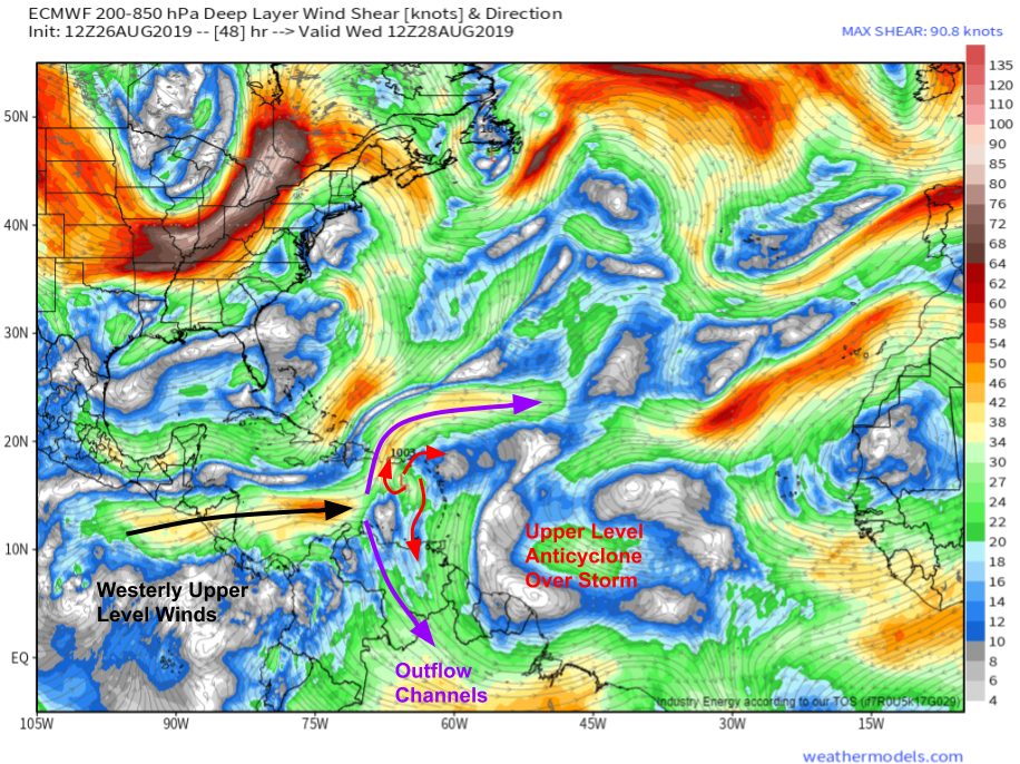
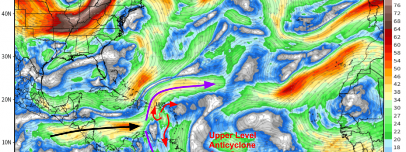
That upper level low I mentioned up there was forecast to contribute to Dorian’s weakening by tilting its thunderstorms so that they would have a harder time staying organized. A few subtle shifts are noted in more recent model guidance, which shows that stream of westerly winds splitting into two branches before it encounters the storm. Those branches will be fanning out away from the storm, helping the system’s upper level anticyclone to vent air away from the center of the storm, making space for more air to rise in the storm’s updrafts. Map via weathermodels.com.
Assuming the storm can fend off intrusions of mid level dry air, its next challenge will be the islands of Hispaniola and Puerto Rico, where it is forecast to arrive as a hurricane on Wednesday.
Mountainous islands like Hispaniola and Puerto Rico can disrupt tropical cyclone circulations via the effects of friction. As the storm moves over (or near) the mountains, the winds slow down due to enhanced friction. This throws a big wrench into the inner workings of a tropical cyclone, which depends on the transport of warm moist air from the fringes of the system to sustain the powerful heat engine at the center of the storm. Additionally, when a storm moves over any land (regardless of how mountainous), it is deprived of its fuel source: warm water. With that in mind, the extent to which Dorian interacts with Hispaniola and Puerto Rico will play an important role in its longer term future.
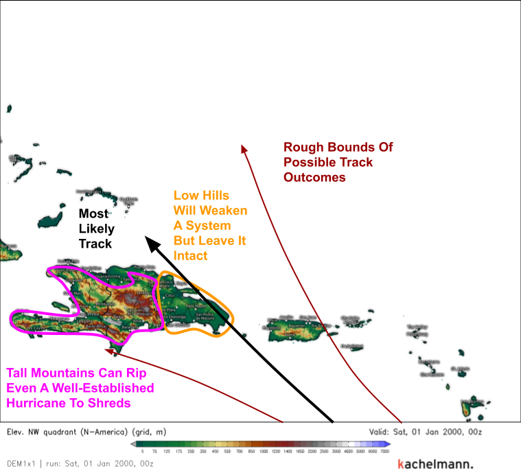
Here’s a look at the topography of this part of the Caribbean, along with the expected path of Dorian. The current NHC and EPS consensus track forecasts take the storm’s center over the eastern part of Hispaniola, where the terrain is much flatter compared to the island’s central and western regions. If that track were to verify, Dorian would weaken, but it would survive. If the storm moved farther east, it would encounter Puerto Rico which has a few tall mountains, but generally not enough to wipe out an established cyclone. There would be more weakening than a track through the Mona Channel between the islands, but the storm would remain a threat as it tracked NW towards the Bahamas. If the system moved farther west into Central Hispaniola, it would likely dissipate in the tall mountains of the Dominican Republic and nearby Haiti. Regardless of the storm’s exact track and eventual fate, these mountains will do an excellent job squeezing moisture out of the air, resulting in tremendous rainfall. The heavy rain combined with weak infrastructure and deforested slopes will make this a very dangerous storm for the island of Hispaniola, regardless of its exact strength.
Here’s a look at the EPS’ thoughts on the storm’s future over the next 10 days.
The storm is already impacting the Windward Islands with heavy rain and strong winds. Any last preparations should be rushed to completion. There is high confidence in the storm’s track forecast (generally speaking) through Wednesday when it will arrive in either Hispaniola or Puerto Rico. After that, the storm will move NW towards the Bahamas before taking a turn back to the west on Friday in response to a building upper level ridge near Bermuda. After that, there’s no way of knowing at this time where the storm might track or how strong it might be. The range of possible outcomes presented by the EPS stretch from dissipation over Hispaniola to a Gulf of Mexico hurricane to recurvature off the East Coast. Map via weathermodels.com.
Why is the long term forecast so complicated?
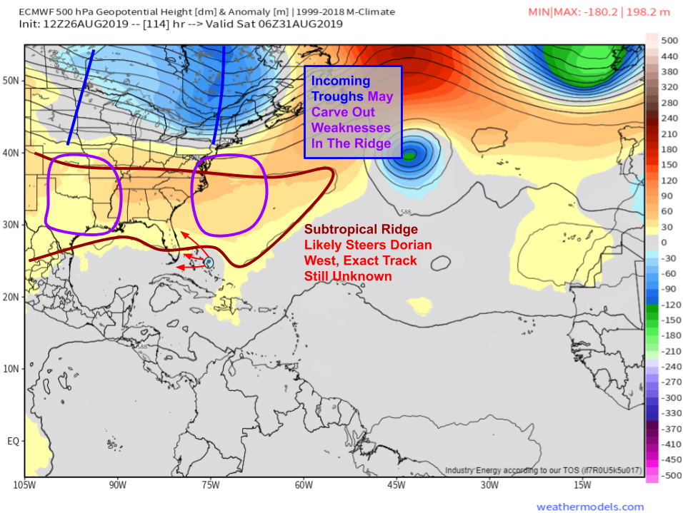
Here are the features that will be important to Dorian’s track once it arrives in the Bahamas (if it survives Hispaniola). The subtropical ridge will be trying to rebuild over the Southeastern US and adjacent parts of the SW Atlantic, but two disturbances in the Polar jet will be chipping away at the ridge from the north. Depending on where those disturbances are, and how strong they end up being, the subtropical ridge could push the storm west into the Gulf of Mexico (weak/farther north disturbances) or it could split into two segments, with Dorian escaping to the northeast through the gap (stronger/farther south disturbances). Why can’t we figure out what those disturbances will do? One is currently part of a storm south of Alaska, and the other still needs to be pieced together from a few disturbances meandering through the Subtropical Pacific as well as energy released by thunderstorms that may or may not form in the Plains 4-6 days from now. Map via weathermodels.com.
We’ll have much more information in the coming days as we get more clarity regarding all parts of Dorian’s future from Hispaniola to Florida and beyond. If you live in Florida, there’s never a bad time to think about your hurricane plan and make sure you’re stocked up on non-perishable essentials, but it’s way too early to seriously worry about Dorian. Any impacts from the system are still almost a week away.
Follow us on twitter for more frequent updates @WeatherdotUS/@JackSillin.
-Jack
