Tropical Storm Cristobal Continues Organizing In The Gulf of Mexico, Extent Of Eventual US Impacts Remains Uncertain
Hello everyone!
Tropical Storm Cristobal has now been named in the southern Gulf of Mexico after Tropical Depression Three began producing maximum sustained winds in excess of 39 mph (click here to read more about how tropical cyclones are classified/named). The system is drifting ever so slightly south/southeast in a region of weak steering currents near the Mexican coastline. While forecast uncertainty remains high, especially regarding the system’s eventual intensity, we’re slowly making progress towards narrowing down the range of possible outcomes.
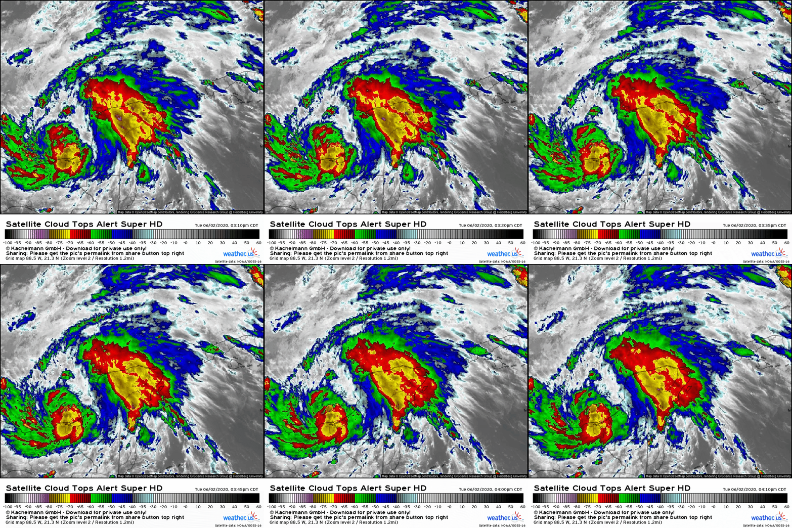
Satellite imagery this afternoon shows a slowly organizing system still embedded within the larger Central American Gyre. The gyre circulation is helping maintain that area of robust thunderstorm activity over the northern Yucatan Peninsula which may be modestly inhibiting Cristobal’s development. Either way, the system now has the beginnings of a Central Dense Overcast (CDO) as thunderstorm activity has become more consolidated around the system’s center. Additionally, the system is benefiting from expansive upper-level outflow in all directions, as shown by the cirrus plumes sweeping away from the center in a generally clockwise trajectory. The system does appear to be struggling against a bit of northwesterly wind shear, as shown by the lack of deep convection northwest of the system’s center. Given the modest shear and proximity to land, I wouldn’t expect any rapid intensification from Cristobal in the next day or two, but the system appears well-positioned to strengthen into a mid-grade tropical storm with winds of 50-60 mph.
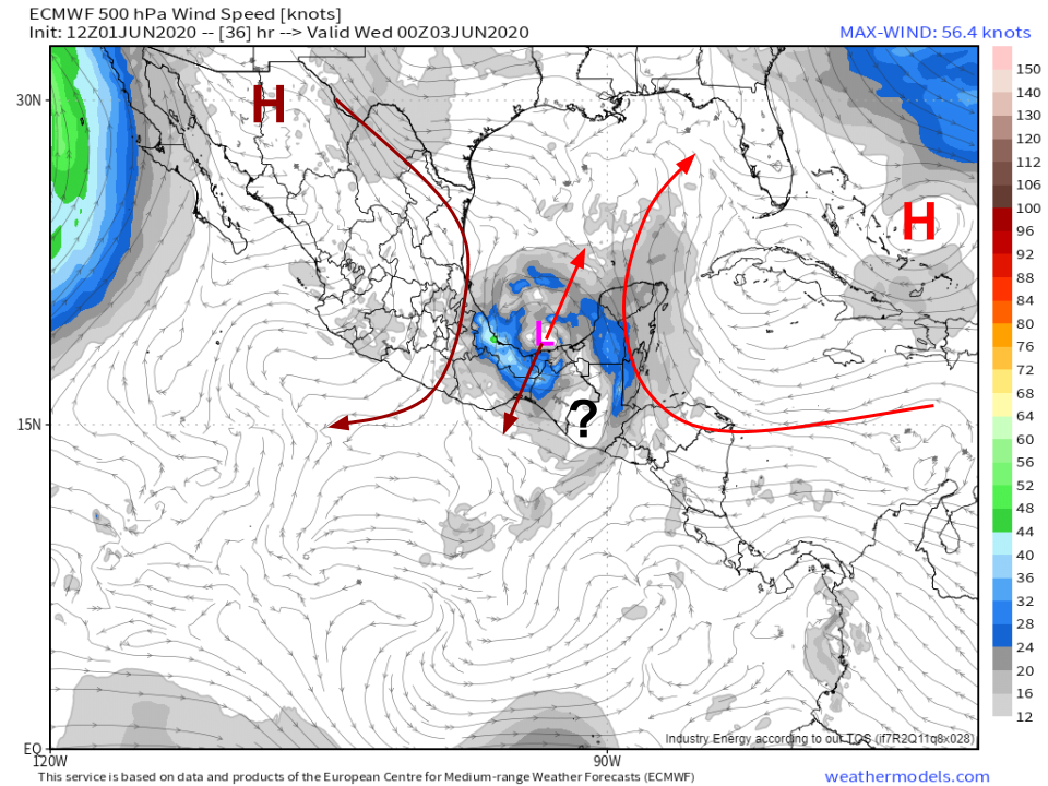
I made this steering graphic yesterday but it remains completely relevant to today’s discussion. The image is valid at 7 PM EDT today, and shows Cristobal caught between two upper-level ridges. These ridges are steering Cristobal in opposite directions and are exerting a roughly equal force in each direction. As a result, the system will remain nearly stationary for the next couple days.
The critical question is to what extent its center will drift over land. If the center remains over water, or only drifts onshore for a brief time, it is unlikely to be meaningfully disrupted. However, if the center spends the better part of a day or two wandering around the western Yucatan Peninsula, it may re-emerge in the Gulf of Mexico in a greatly weakened state. This is not the same scenario discussed in previous days which showed the system completely disintegrating over the mountains of south-central Mexico. That scenario is now off the table because the system didn’t move nearly as far west as was originally anticipated yesterday. Very small changes in the short-term forecast have a huge impact on what happens in the long term!
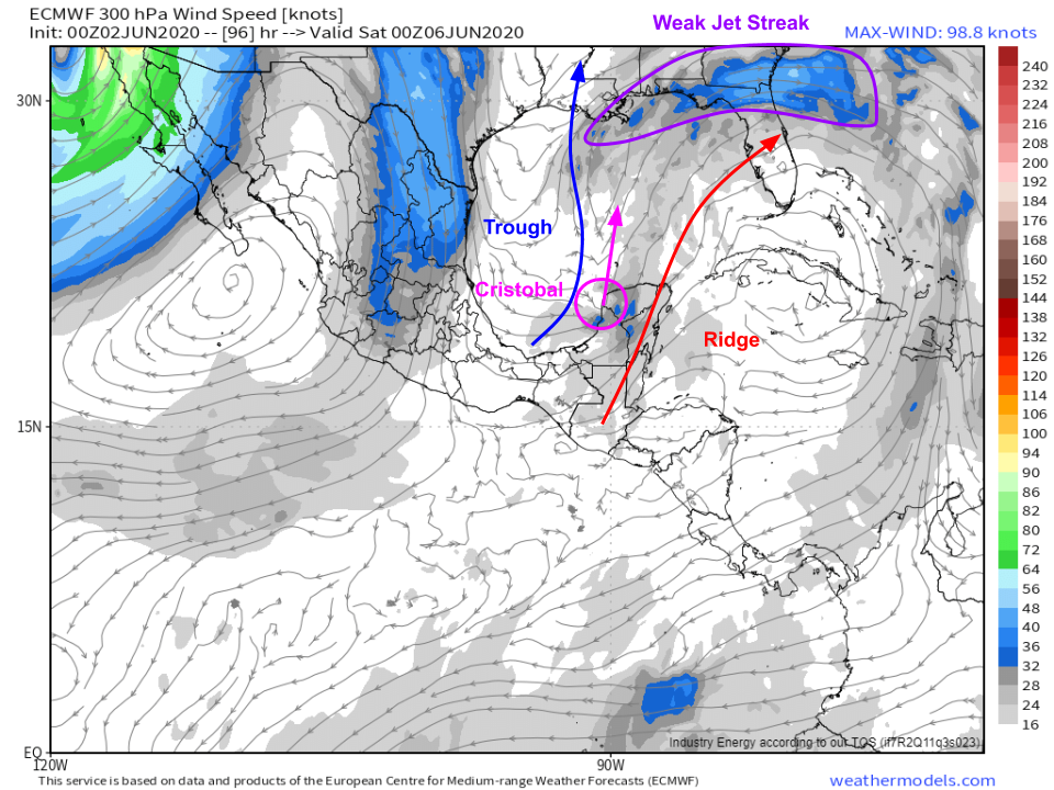 By Friday, the ridge to the west of the system (pushing Cristobal south) will slide into the Eastern Pacific and will be replaced by a trough drifting south from Texas. That trough will team up with the ridge still in place to the east of Cristobal to push the system north (or north-northeast). As this acceleration takes place, the system will enter the right entrance region of a weak jet streak over the far northern Gulf of Mexico and adjacent parts of the Florida panhandle. This, combined with an increase in southerly shear (again due to that trough) will help elongate the system so it becomes “top heavy” with most of the heavy rain and wind on the northern side of the storm’s center. It’s not exactly clear what this will do to the system’s intensity. Some tropical cyclones, upon interaction with a trough like this, strengthen while others fall apart. I think the most likely answer for what happens to Cristobal is that the answer depends on what happens tonight/tomorrow as the system drifts near or over land. If the system weakens considerably over land, it will lack the strong inner core needed to stand up to the trough, which means that the increase in southerly shear would hollow out the system and cause it to weaken. If the system is able to continue organizing such that it has a well-defined eye and eyewall, it will be much more resilient to the shear associated with the trough, and consequently will be much more likely to maintain its strength (or even intensify) on approach to the Gulf Coast.
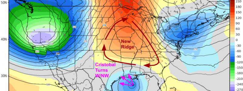
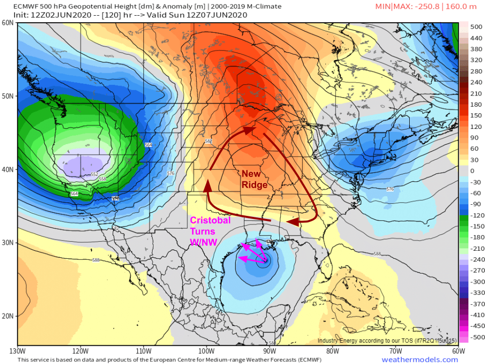 Another question mark comes as the system nears the Gulf Coast on Sunday morning. By then, a new ridge (neither of the original two we talked about earlier!) will be building over the Mississippi Valley. The clockwise flow around this feature will attempt to steer Cristobal back towards the west or northwest. The timing of this shift in track as well as the magnitude of the shift will depend on exactly how the ridge evolves which, of course, is uncertain. However, this ridge is likely to be the feature deciding where Cristobal ends up making landfall.
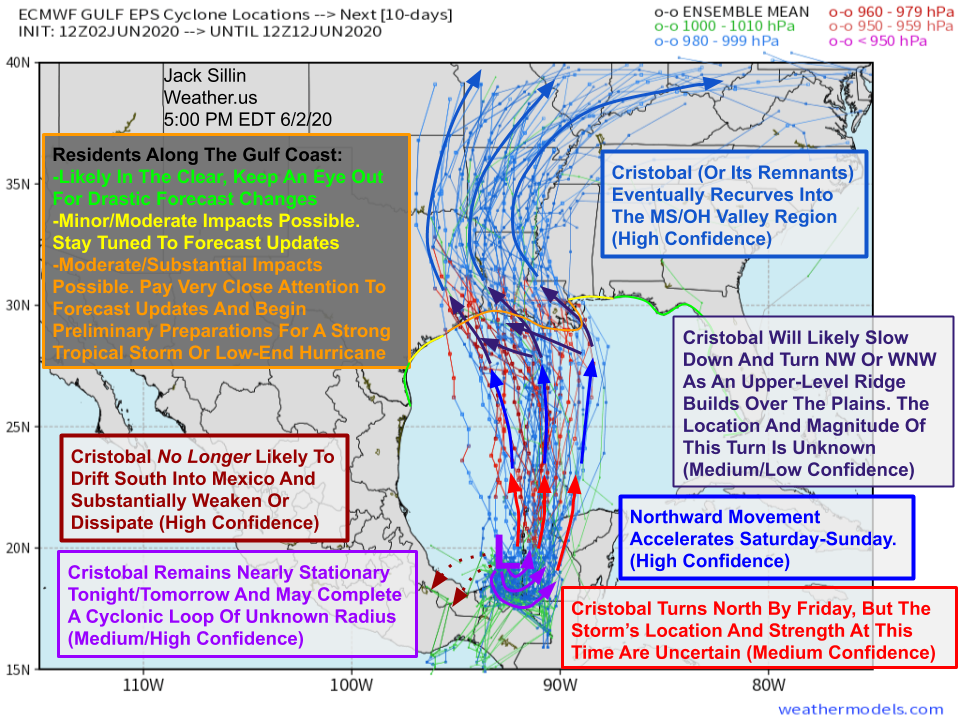 I’ll end this post as I always do, with a look at my annotated EPS spaghetti forecast from the most recent 12z run (this afternoon). I’ll let the graphic do most of the talking, but I do want to emphasize that since we can now safely discount the “dissipate over the Mexican mountains” scenario, residents of the Gulf Coast need to be paying extra-close attention to forecasts this week. This is especially true for folks west of the Florida Panhandle and east of Corpus Christi Texas. While it’s perhaps too early to completely discount the possibility of a landfall in northern FL or far western TX, I feel pretty good about saying that these scenarios are unlikely at this time. If you live in southeastern Texas or Louisiana, you should start to think about preparing for the possibility of a strong tropical storm or lower-end hurricane making landfall Sunday or Monday. Review your hurricane plan, start stocking up on any non-perishable supplies you might be running low on after the recent/ongoing COVID-19 quarantine situation, and make sure you’re ready to act if this system ends up being on the stronger side and ends up headed your way.
I’ll have more updates in the coming days as the forecast becomes clearer.
-Jack
