Tropical Storm Barry Slowly Strengthening In The Gulf This Morning, Major Flooding Expected In Louisiana
Hello everyone!
Today’s update on the tropical system in the Gulf of Mexico, now termed Tropical Storm Barry after acquiring a closed center of circulation midday yesterday, will follow a similar path to that of yesterday’s, which can be found here. I’ll briefly outline how the system is doing now, but will spend most of the time looking at the threat for major flooding in parts of Louisiana. Regardless of how strong the storm’s maximum winds become, the biggest risk to those in Barry’s path will be the flooding, which will come both from extremely heavy rain, and from the system’s storm surge. Remember that all information I present here is meant to supplement, not replace, official information from the National Hurricane Center and local authorities.
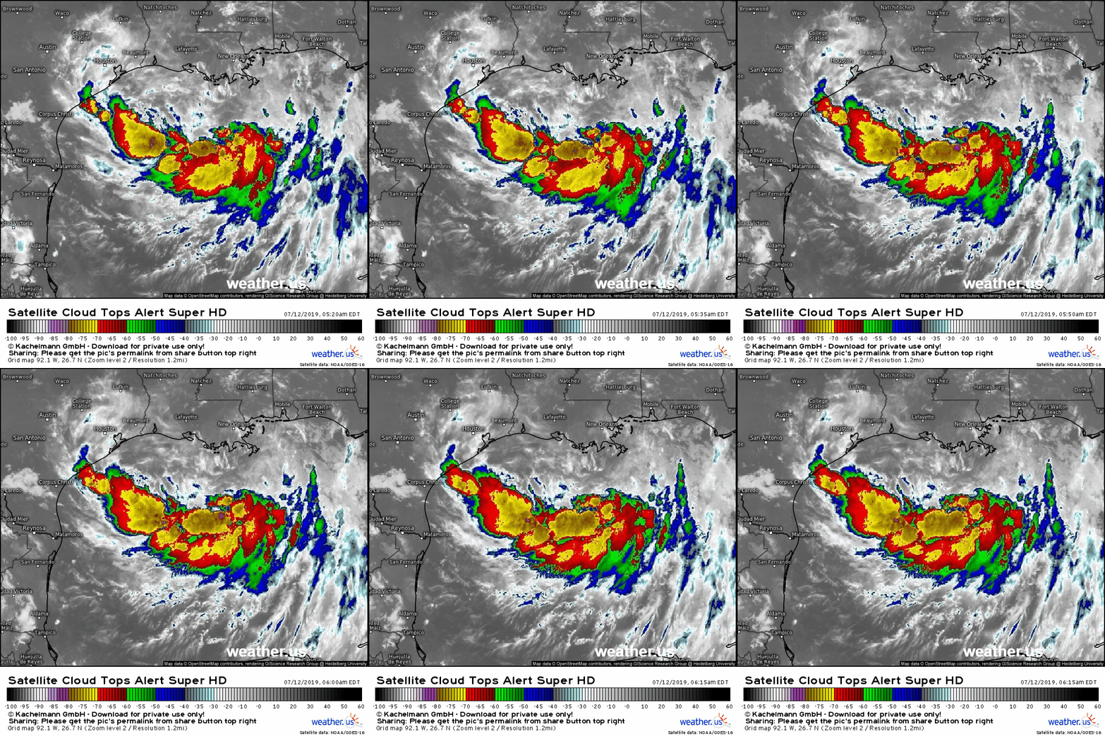
Satellite imagery this morning shows a disorganized system being affected by a bit of dry air and wind shear from the north. That said, there is much more thunderstorm activity this morning compared to yesterday, and there is good upper level outflow extending in nearly all directions to help ventilate the system. Any further intensification will depend on whether the system can fend off the shear and dry air on its northern side.
Here’s a look at how the wind shear and dry air situation is expected to evolve between this morning and late tonight. The right two panels are this morning’s analysis by the ECMWF and the left two panels are the forecast. The panels on the top show winds at 300 mb, about 30,000 feet above the ground. The bottom panels show the relative humidity at the same level.
Unsurprisingly, the morning analysis shows northeasterly winds encroaching on the storm’s circulation and pushing dry air from the northern Gulf of Mexico into the storm’s circulation. That’s responsible for the lack of thunderstorm activity on the storm’s northern side that we saw in the satellite imagery above.
By the time we get to tonight, the wind shear situation will be much better for the storm as the large ridge pushing those northeasterly winds weakens. That weakness in the ridge is what will allow the storm to turn towards the north into the Louisiana coastline. As a result, the system should be able to wrap thunderstorm activity around its north/northeastern side.
The dry air situation however will remain unfavorable, especially on the western side of the storm. This means that the storm is likely to continue to struggle unless it builds a ring of thunderstorms around its center that can hold that intrusion of dry air at bay. Based on current trends and the shear situation through the afternoon hours, I think this is relatively unlikely. As a result, the storm’s peak intensity at landfall will probably fall near the lower end of the range of possible outcomes I presented in previous updates. We’ll likely be talking about a moderately strong tropical storm instead of a low end hurricane. While this might be good news for a few folks right at the coast where the core will come ashore, it changes nothing for the rest of Louisiana’s eastern half which will still be getting extremely heavy rain over the next couple days.
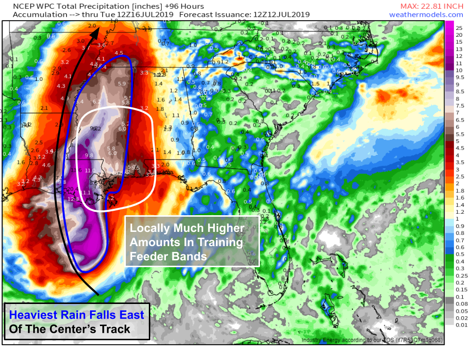
Here’s a look at how much rain is forecast to fall by the WPC, which uses a combination of computer guidance and human analysis to arrive at its precipitation forecast products. The heaviest rain will be found on the eastern side of the storm as it moves ashore, owing to the presence of dry air on the western side. Much of southeastern Louisiana can expect more than a foot of rain to fall in the next 2-3 days with lesser amounts to the north and east, as well as closer to the track of the storm center itself. In the area east of the center as it moves ashore, spiral ‘feeder’ bands will be moving onshore, and their orientation will be largely parallel to the large scale flow in the area (out of the south). This means they will be ripe for ‘training’ thunderstorms, a situation where thunderstorms move repeatedly over the same areas like train cars moving along the railroad tracks. I would not be surprised to see totals in this area locally exceed two feet. This amount of rain, much of which will fall in very short periods of time, will cause extreme flash flooding. It is too early to pinpoint exactly which towns will be most impacted, but anyone in this area needs to be preparing as if 20″ of rain were set to arrive over a period of 6-12 hours. Map via weathermodels.com.
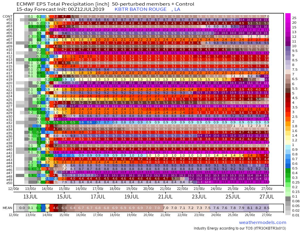
This plot shows the rainfall forecast for Baton Rouge, Louisiana arrived at by each of the 51 ECMWF ensemble members. Each row is one member forecast and can be thought of as one possible outcome. Note that while the ‘consensus’ average forecast is for 6-7″ of rain, there are many scenarios where the city picks up over 10″ of rain as training thunderstorms move repeatedly over the area. However, if those bands set up in the next town over, much lower totals are possible. Because the ensemble members are run at too low a resolution to resolve thunderstorms explicitly, the model will generally be too bearish on the chance for extremely high rainfall totals, and too bullish on the odds of a total ‘bust’ with very little rain. While that doesn’t mean the information isn’t valuable, it is an important lens through which to look at and interpret these data. Chart via weathermodels.com.
Heavy rain will continue to fall along the storm’s path as it moves north and eventually northeast during the first half of the upcoming week.
How can you keep track of Barry over the next few days? We have lots of tools at weather.us to supplement the official info you can get from the National Hurricane Center.
Follow along with what the storm is doing now by looking at GOES-East satellite imagery (tutorial video), HD radar imagery, and current observations including wind speed and rainfall.
Understand the range of possible outcomes for the storm’s future by looking at the EPS storm tracks map (tutorial video), and our Forecast Ensemble output (tutorial video) for your specific location.
Get my latest updates and analysis on twitter @WeatherdotUS and @JackSillin.
-Jack


