Tropical Disturbance To Bring Torrential Rains To Parts Of The Gulf Coast This Weekend
Hello everyone!
An area of low pressure is currently producing disorganized shower and thunderstorm activity east of Mexico’s Yucatan Peninsula. This disturbance will drift northward over the next few days, and could consolidate into the first tropical or subtropical cyclone of the year. While the system’s eventual designation as a named storm remains uncertain, we have high confidence in its impacts, the primary one being heavy rain. The system will bring moisture and rising motion to much of the eastern Gulf Coast for a prolonged period this weekend into early next week, resulting in many days of torrential downpours which, while manageable on their own, will add up over a longer period of time.
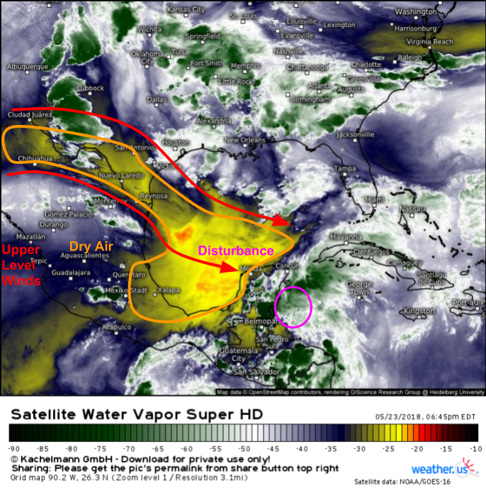
Here’s a look at the disturbance and its surrounding environment via GOES-East WV imagery. The disturbance can be seen as the area of shower and thunderstorm activity east of the Yucatan Peninsula. The environment is what I want to go over briefly now, because that’s what will shape the system’s evolution over the next several days. As is typical for the early season, the environment across the Gulf of Mexico is fairly hostile to tropical cyclone development. Dry air is being blown towards the disturbance by strong upper level winds. These winds prevent the disturbance’s thunderstorms from organizing, while the dry air chokes the thunderstorms’ updrafts, killing them off altogether. The dry air and wind shear will prohibit development for the rest of this week, but both are expected to relax a bit once we approach the weekend.
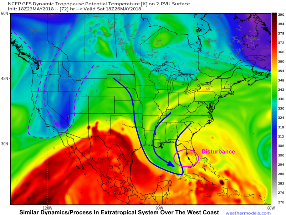
As the system moves north this weekend, it will attempt to develop into a hybrid tropical-subtropical storm. What’s the difference between a tropical and a subtropical storm? A tropical storm relies purely on warm water for its energy source, while a subtropical storm taps into both warm water and upper level dynamics for its energy. This map from the GFS model shows upper level energy “draining” into the system from the northwest, a process also found in the purely extratropical system over the West Coast. Because of these non-tropical processes, the system is very unlikely to become purely tropical. However, given sufficient organization of thunderstorm activity, it could tap into the warm waters of the Gulf of Mexico enough to be designated as a subtropical storm.
Map via weathermodels.com.
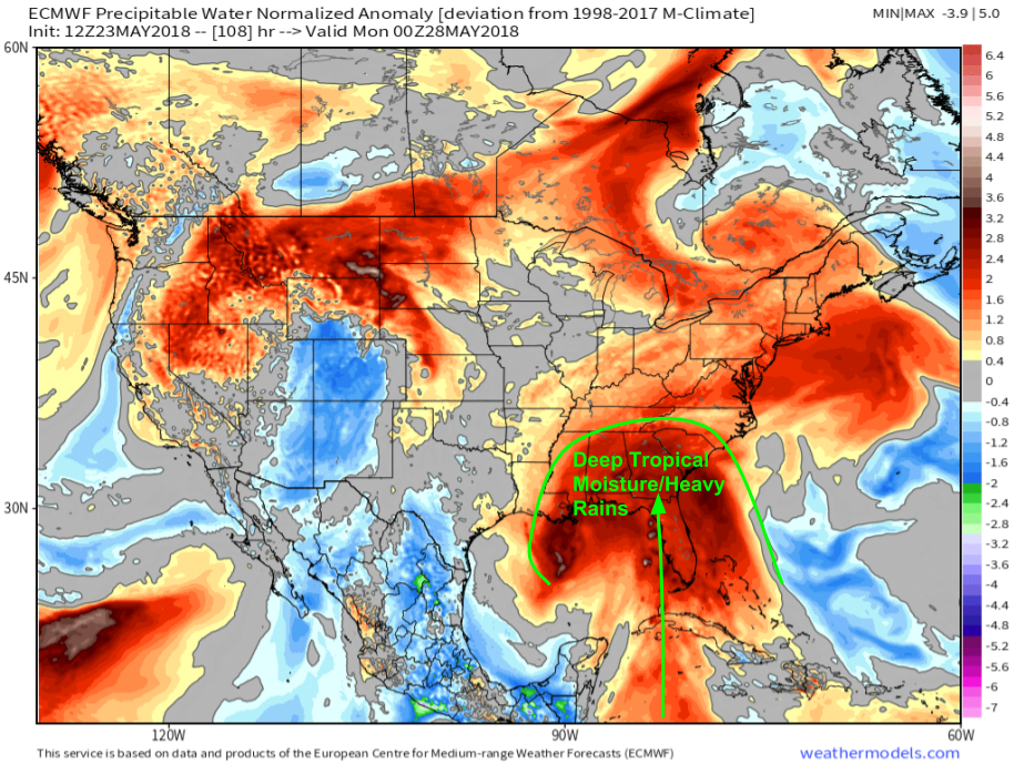
Whether or not the storm ends up becoming an officially named entity will be more of a semantics exercise than anything else. For residents from New Orleans through the Deep South and into Florida, this system will be a heavy rain producer, official designation or not. This map from the ECMWF shows the precipitable water (moisture) anomaly on Sunday evening. The wide swath of anomalously moist air will fuel heavy rains across much of the Southeast this weekend. The heaviest rains will be along the axis of deepest moisture (somewhere near the Florida peninsula) and near the center of the storm (somewhere to the west of that). The exact locations of each of these features remains slightly uncertain, but the broader impact will remain constant regardless of the center’s exact track.
Map via weathermodels.com.
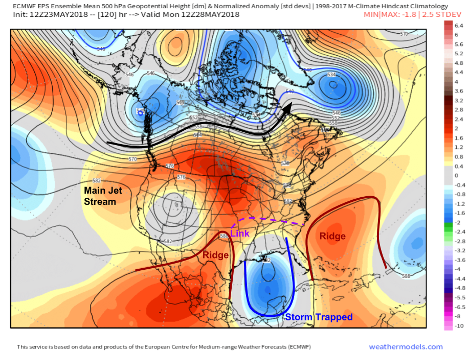
As we move into the early part of next week, the storm will prove slow to exit. This EPS (ECMWF ensemble) forecast shows the storm over the Gulf of Mexico blocked in by two ridges of high pressure, which develop a connection over the Southern Ohio Valley and Mid Atlantic. This connection will act as a “lid” of sorts, keeping the storm pinned in the Gulf of Mexico. As a result, this will keep the rain falling from Florida through the rest of the Southeast.
Map via weathermodels.com.
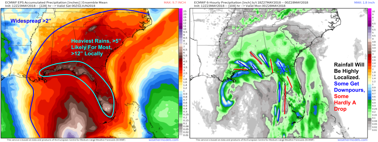
How much rain is expected to fall? ECMWF ensemble forecasts paint a broad swath of amounts over 2″ from Louisiana north into the Mid Atlantic and east through Florida. The jackpot zone for the highest totals will be found right along the Gulf Coast from SW FL to E LA. In these areas, most folks will likely pick up at least 5″ of rain, with localized amounts in excess of a foot possible. The map on the right is the ECMWF’s forecast for precipitation between Sunday at 2 PM EDT and Sunday at 7 PM EDT. This “snapshot” gives us insights into the distribution of precipitation instead of just how much is expected to fall at the end of the event. Notice the narrow areas of very heavy rain located close to similarly narrow areas of very light rain. This will be typical over the next week as localized bands of heavy showers and thunderstorms pour down on one town, while the next stays high and dry.
Maps via weathermodels.com.
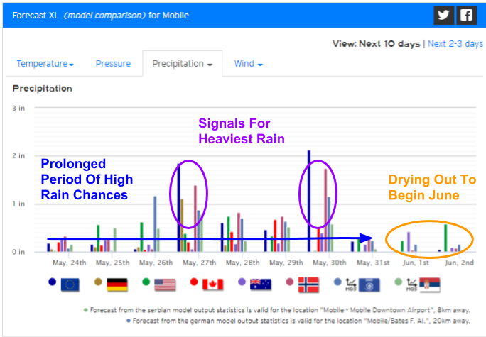
Here’s a look at the overall trajectory of this event in Mobile Alabama, as shown by our Forecast XL product. Each small bar represents one model’s forecast for the precipitation during a given day, and each cluster of bars represents all the models’ forecasts for a given day. The more models forecast precipitation, the more likely it is to occur. Notice the very high confidence in precipitation over the next week or so, before a drying trend to start off June. Some days the odds of heavy rain will be higher, though remember the distribution of precipitation will be highly localized, so areas that get downpours one day may see very little the next day. After about a week or so, the system will depart and drier weather will return.
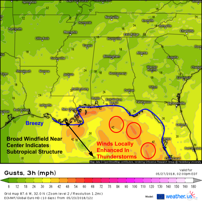
Here’s a look at the ECMWF’s wind forecast for Sunday afternoon. Breezy conditions are expected across much of the eastern Gulf Coast, but no significant winds are forecast to develop from this system. The broad windfield is characteristic of a subtropical storm, and the system lacks any inner core type structure to support intense winds. That being said, any thunderstorm activity on the periphery of the system will locally enhance winds, and some damaging gusts can’t be ruled out.
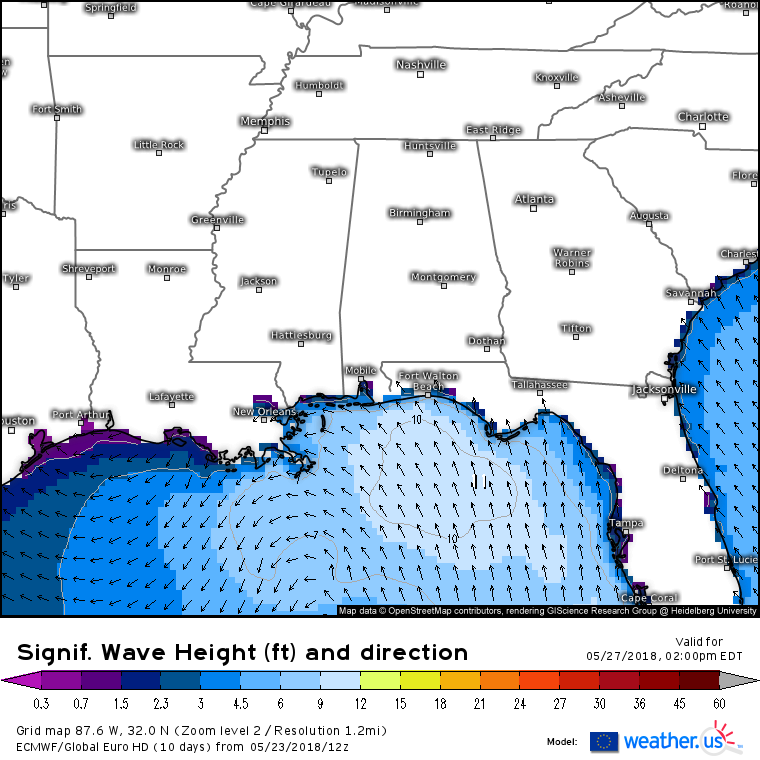
Breezes associated with the storm will create choppy conditions out on the waters of the Gulf, as shown by this wave height forecast for Sunday afternoon. While seas will be hazardous to boaters, and localized splashover/minor coastal flooding can’t be ruled out, no major storm surge issues are expected due to the weak and diffuse nature of the storm.
Keep a close eye on satellite imagery and follow along with all the latest model runs both on weather.us and weathermodels.com to stay ahead of the storm in the coming days.
I’ll have more updates on this system on twitter over the course of the coming days.
-Jack
