Tropical Disturbance 91L To Bring Heavy Rain To Texas This Coming Week
Hello everyone!
While the first two weeks of the 2018 Atlantic hurricane season have been relatively devoid of activity, a weak tropical disturbance currently located in the Caribbean will bring some impacts to Texas this coming week, primarily in the form of heavy rain. The system is unlikely to consolidate enough to bring much in the way of high winds or storm surge, but breezy conditions and slightly higher than normal water levels are both possible along the immediate coastline. Because the system will remain diffuse, it will likely linger through much of the week, though the heaviest rains will be Monday and Tuesday.
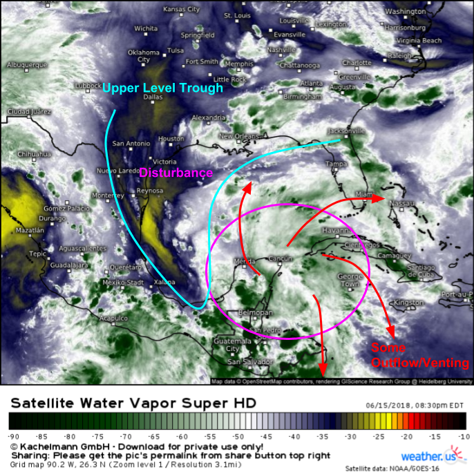
GOES-East water vapor satellite imagery provides a good overview of the disturbance’s current state this evening. The system itself is little more than a disorganized cluster of shower and thunderstorm activity in the general vicinity of Cancun. Meanwhile, an upper level trough is located to the west of the disturbance. Wind shear and dry air associated with that trough will keep a lid on how much the disturbance can consolidate before arriving in Texas later this weekend.
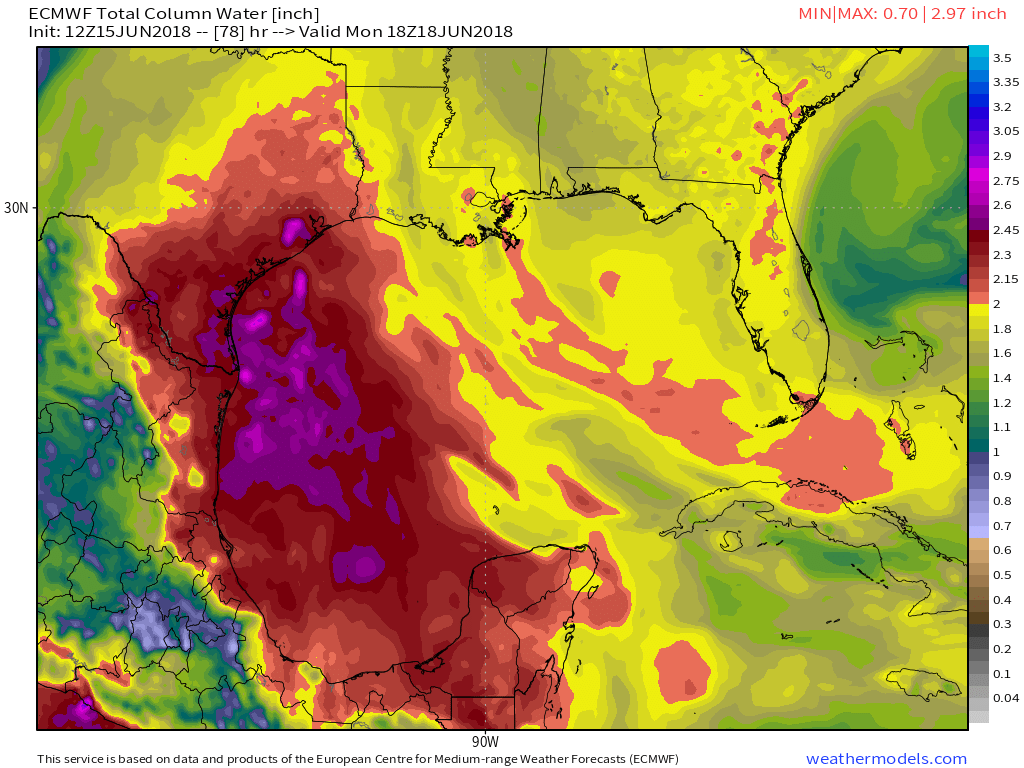
While the upper level trough will keep the system’s circulation disorganized, it will do very little if anything to hold back the plume of tropical moisture associated with the disturbance. This map from weathermodels.com shows the system’s plume of tropical moisture surging into Southeastern Texas on Monday afternoon. The tropical moisture will be responsible for creating the heavy rain/flooding threat, in spite of the system’s lack of organization.
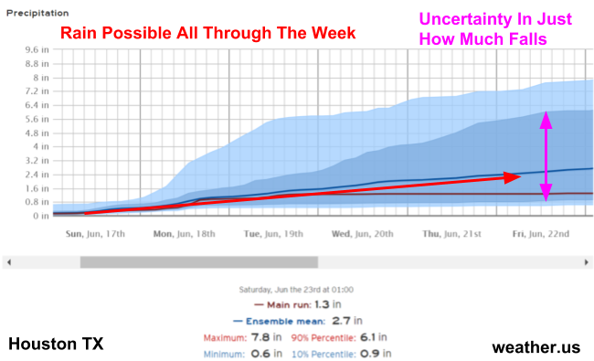
A look at our Forecast Ensemble product for Houston TX shows rain chances beginning to pick up on Sunday, and continuing through the duration of next week. Most of the rain associated with this system will fall from thunderstorms, which will pop up each afternoon. Exactly where these storms pop up will determine who exactly gets the most rain. As a result, the rainfall forecast for any one location, such as Houston, remains uncertain, as shown in the plot above where the range of plausible outcomes stretches from just under 1″ to over 6″. It’s impossible to know where these storms will pop up until they actually appear on HD radar imagery.
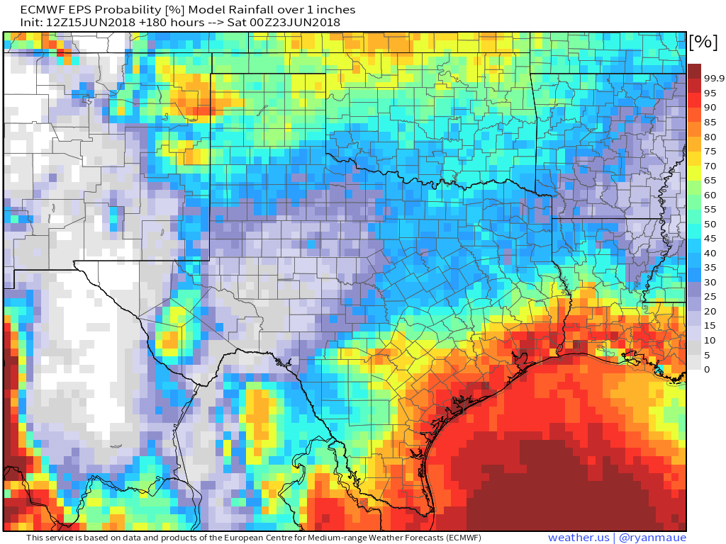
While the rainfall forecast for any one location may remain uncertain, some places have higher chances at heavier rains than others. This map from weathermodels.com shows the odds of rainfall totals exceeding 1″ between now and the end of next week. This map smooths over some of the uncertainties discussed above, and shows us that the coastlines of TX and SW LA, extending 50 or so miles inland, stand the best chance at seeing the most rain. Areas farther inland, towards Austin, are less likely to see the heaviest rains, though keep in mind that individual thunderstorms may create localized exceptions to that rule.
Moisture will gradually drift back offshore in about a week’s time, leading to diminishing rain chances. As I mentioned earlier, while no significant wind or surge hazards are expected, breezy conditions and some unusually high water levels are possible, especially if the disturbance is able to consolidate a little more than current forecasts indicate.
-Jack


