Tropical Depression Three Forms In The Southern Gulf Of Mexico
Hello everyone!
At 5 PM EDT today (June 1st, 2020), the National Hurricane Center determined that the tropical disturbance emerging in the Gulf of Mexico met the criteria to be designated tropical depression three. What are those criteria? You can learn about what makes a tropical cyclone a tropical cyclone in the first installment of our “Tropical Cyclones 101” series.
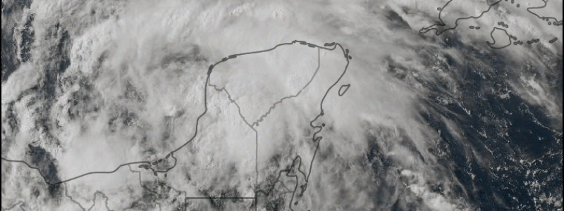
Satellite imagery shows a somewhat hollowed out system with the center of circulation displaced from the regions of most persistent deep thunderstorm activity. However, the storm’s center is now out over the warm waters of the Bay of Campeche, and cirrus clouds fanning out clockwise away from the center suggests that upper-level winds are favorable for further intensification. Regardless of the system’s near-term strength as quantified by maximum wind speed, persistent thunderstorm activity will continue to drop flooding rains on parts of southern Mexico, Guatemala, El Salvador, and Honduras.
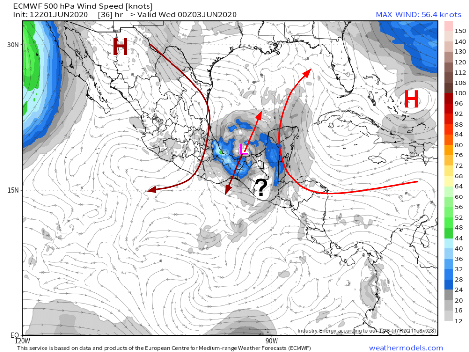
Over the next 24 hours, the system will slowly drift west(ish) into the central Bay of Campeche as it’s steered by a ridge of high pressure over the Bahamas and the circulation of the gyre in which it’s embedded. After that, the question marks start piling up regarding the system’s track.
 The ECMWF’s 500mb wind forecast does a great job highlighting the quandary facing TD3 and those attempting to forecast its track. The system will be stuck between two high pressure systems each steering it in opposite directions. Unfortunately, the steering influence of each high is roughly equal, which means there’s no clear sense of which direction the system wants to go. TD 3 (by then likely TS Cristobal) may stall out or do a very slow loop either over the Bay of Campeche or adjacent portions of the Mexican coastline. If the system stays offshore (even by just a few miles), it will continue steadily strengthening. If the storm meanders onshore, it could dissipate rapidly.
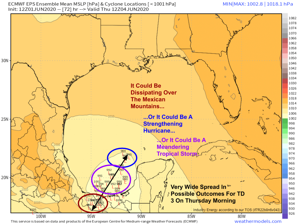
EPS forecasts for Thursday morning (not even 72 hours away!) highlight this tremendous uncertainty. Some ensemble members indicate that TD3 will drift onshore over southern Mexico and dissipate. A majority (though not by much) suggests that the system will remain close to where it is this evening as a weak/moderate-strength tropical storm. A smaller minority suggests that the storm could already be moving north through the Gulf of Mexico as a strengthening hurricane. It’s important to emphasize that while the most likely outcome is that “middle of the road” weak tropical storm in the Bay of Campeche scenario shown by the majority of ensemble members, there’s no compelling reason to disregard either of the minority forecast groups showing the outlier solutions. It’s just too soon to know what will happen given the sensitivity of the system’s medium-range forecast to processes that model guidance is not well-suited to handle.
For an explanation of the EPS ensemble system (and ensembles more generally), check out this post and this tutorial video.
What’s the bottom line? Unfortunately, we just don’t know what’s going to happen at this point. However, I think we can say with some confidence at this point that impacts from a tropical cyclone of some unknown intensity are likely along the US Gulf Coast sometime either this weekend or early next week. Even if the system dies out over Mexico in a couple days, another system (!) could form from this same gyre later in the week. Most of the guidance that shows TD 3 dissipating also shows the development of that second system in to a weak/moderate tropical storm.
So when will we know what to expect from TD3? I think we should start to get a better idea by Wednesday, and I think we’ll be much more confident by Thursday when the system will either be headed for a mountainous grave south of Veracruz, or will begin turning north/northeast towards the central Gulf of Mexico. Until then, residents of the Gulf Coast should remain vigilant and tuned into the latest forecasts, especially those coming from the National Hurricane Center. Now, being the first day of the 2020 hurricane season, is also a great time to double check your hurricane plan, make sure to make any adjustments needed to adapt to the COVID-19 situation, and stock up on any non-perishable supplies you might be low on. Even if this storm doesn’t threaten your area, another one will eventually.
-Jack


Hey there just wanted to give you a quick heads up. The text in your content seem to be running off the screen in Firefox.
I’m not sure if this is a format issue or something to do with internet browser compatibility but I thought I’d post to let you know.
The design look great though! Hope you get the problem
solved soon. Thanks