Tropical Cyclones 101: How Do Tropical Cyclones Form?
Hello everyone!
The 2020 Atlantic Hurricane Season is now officially underway (as of June 1st) which means that it’s a great time to brush up on your knowledge of tropical cyclones. The more familiar you are with these systems and how they work, the better prepared you’ll be to follow along with forecast discussions when a tropical cyclone approaches the coastline. This is the third in a several-part series (“Tropical Cyclones 101”) aimed at bringing everyone up to speed on what tropical cyclones are, how they work, and how you should prepare for their impacts. This post will discuss the formation of tropical cyclones.
For a tropical cyclone to form, we need five “ingredients” to come together at the same time and place: warm waters, low vertical wind shear, mid-level moisture, a sufficiently strong Coriolis force, and a seed disturbance. This post will take a closer look at the importance of each ingredient to the formation of tropical cyclones.
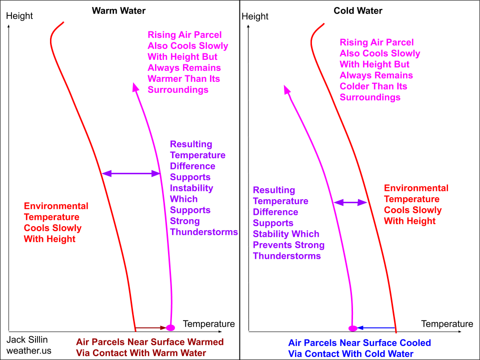
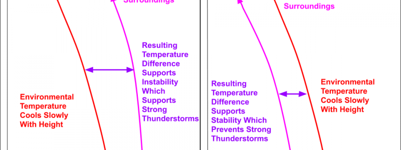
Warm water is important because tropical cyclones, by definition, need abundant thunderstorm activity to generate the pressure gradients which support their strong winds. Recall that thunderstorms can only develop and persist if the atmosphere is unstable which means that a rising air parcel would be warmer than its surroundings (for a refresher on convective instability, click here). In the tropics, the environmental temperature profile is (very generally speaking) not that different across various times and places. Most of the time, the temperature decreases slowly but steadily with height until the tropopause around 100mb. A rising air parcel will cool at a similar rate to the environmental temperature (because the environmental lapse rate is often not so different from the moist adiabatic lapse rate in the tropics, if you’re familiar with that concept). So for a parcel to be warmer than its surroundings, it needs to start off warmer than its surroundings via contact with warm water. The warm water will also evaporate more water vapor into the air, which will provide additional fuel for the tropical cyclone.
So how warm does the water need to be? The generally-accepted threshold is right around 26C or 79F. Occasionally, early season tropical cyclones or those that form via the process of tropical/subtropical transition can make do with ocean temperatures a bit cooler than 26C, but these exceptions are relatively infrequent.
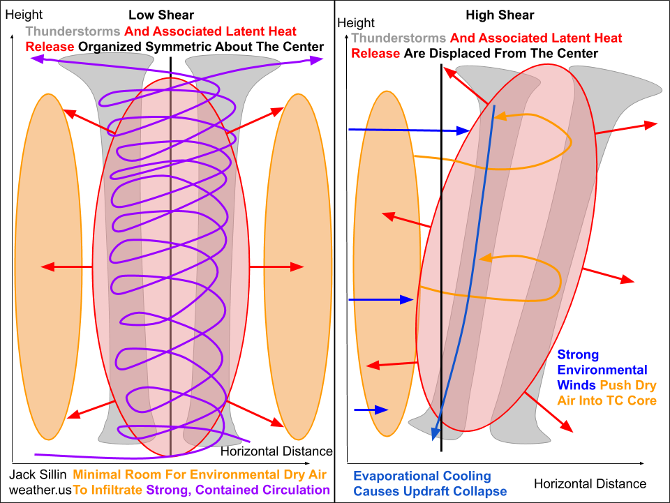
Low environmental wind shear (the change in wind speed and direction with height) is also crucial to the formation of a tropical cyclone. If shear is too high, the thunderstorms comprising the incipient cyclone will tilt, which makes it much harder to establish a coherent column of air being consistently warmed by the processes of latent heat release. In the sheared system, that latent heat release is dispersed over a much wider horizontal area, which will inhibit steep, sustained pressure falls needed to form and strengthen a tropical cyclone. Additionally, dry air is often found surrounding tropical cyclones. In a low-shear environment, the developing cyclone is often able to wall itself off from this environmental dry air (especially in the mid-levels) by developing a relatively self-contained circulation (illustrated with my poorly drawn purple arrows on the left panel). Air is ingested at the bottom of the system (where abundant moisture is provided by evaporation off the ocean) and is subsequently lifted up through the storm before being exhausted out the top. While some exchange of air between the storm and its surroundings does occur in the mid-levels, without strong vertical wind shear, this usually isn’t enough to substantially disrupt a system. When that dry air is forced into the system by strong mid/upper-level winds, much more substantial evaporational cooling can occur which often leads to the total collapse of thunderstorm updrafts. Without persistent updrafts leading to persistent latent heat release, you can’t get a tropical cyclone to form. This also explains why relatively moist air in the mid-levels of the atmosphere is needed.
Our final two ingredients are a seed disturbance, and a healthy helping of Coriolis. The role of the seed disturbance is easier to understand: air at rest tends to stay at rest, and without some external force acting upon it, air near the surface of the ocean will not begin rising upward where it can condense and produce thunderstorms. Seed disturbances in the Atlantic basin are most often tropical waves emerging off the coast of Africa, but old cold fronts and upper-level lows can also serve in that role if conditions are right.
Once a seed disturbance arrives in a favorable environment with warm water, low vertical wind shear, and abundant mid-level moisture, thunderstorms will develop and persist around the disturbance’s center. There’s one more ingredient we need before a tropical cyclone develops: Coriolis. The Coriolis force deflects objects moving long distances to the right in the Northern Hemisphere and to the left in the Southern Hemisphere. This is why air around storms in the Northern Hemisphere circulates counter-clockwise while air around areas of high pressure circulates in the opposite direction. Without this circulation, you won’t be able to get a tropical cyclone to develop. There are, of course, some very rare exceptions to this rule and tropical cyclones have formed near (but never on!) the equator. It is also for this reason that tropical cyclones will never cross the equator. The general rule of thumb (that works the vast majority of the time) is that tropical cyclones will not form within 5 degrees latitude of the equator (either north or south).
It’s also important to remember that tropical cyclone formation is not instantaneous. Even under ideal conditions, it takes some time (usually several days) for a seed disturbance and its associated thunderstorm activity to release enough latent heat to produce a warm-core low with a closed center of circulation, and thus qualify as a tropical cyclone.
-Jack
