Tropical Cyclones 101: How Are Tropical Cyclones Classified And Named?
Hello everyone!
The 2020 Atlantic Hurricane Season is now officially underway (as of June 1st) which means that it’s a great time to brush up on your knowledge of tropical cyclones. The more familiar you are with these systems and how they work, the better prepared you’ll be to follow along with forecast discussions when a tropical cyclone approaches the coastline. This is the second in a several-part series (“Tropical Cyclones 101”) aimed at bringing everyone up to speed on what tropical cyclones are, how they work, and how you should prepare for their impacts. This post will discuss the classification and naming scheme for tropical cyclones.
Before a system meets the criteria to become a tropical cyclone, it may be designated as an Invest by the National Hurricane Center. Invests are identified by a combination of a two-digit number and a letter. The letter designates the system’s basin. For example, an invest in the North Atlantic would be designated with an “L” while an invest in the Eastern Pacific would be designated with an “E”. The number preceding the letter is always between 90 and 99, and simply rotates sequentially each season. The first invest of the season in the Atlantic would be deemed 90L, the second 91L, and so on. The eleventh invest of the season would return back to 90L and the count would reset.
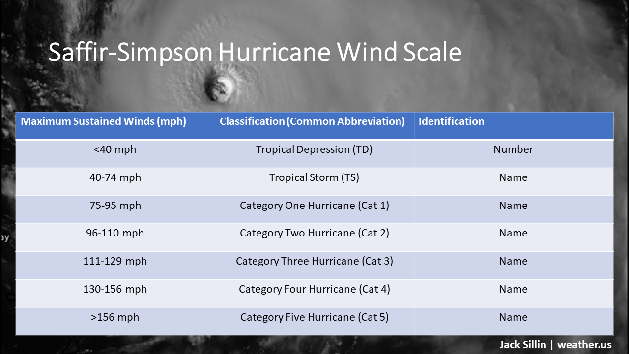
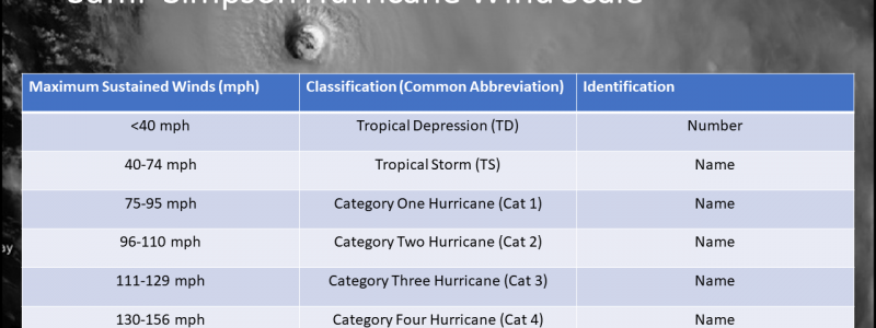
Once a system meets all the criteria to be defined as a tropical cyclone, it is classified based on its maximum sustained wind speed. There is no other classification criteria in use by the National Hurricane Center or any equivalent agency around the world. For the purposes of classification, a cyclone’s storm surge, rainfall, waves, wind gusts, and tornadoes don’t count. Much ink has been spilled about whether this one-variable approach to classifying tropical cyclones should be changed, but the point of this article is to explain how the current system works rather than to advocate for/against tweaking it.
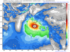
The Saffir Simpson Hurricane Wind Scale, outlined in the graphic above, is the standard used to classify hurricanes in the North Atlantic, Eastern Pacific, and Central Pacific basins. International agencies (NHC equivalents) use slightly different standards, hence the different names you’ll hear about in different basins (typhoons for the Western Pacific and cyclones for the Indian Ocean for example). Because we focus on US weather, this post will stick to the NHC classification scheme for the North Atlantic and Eastern Pacific basins.
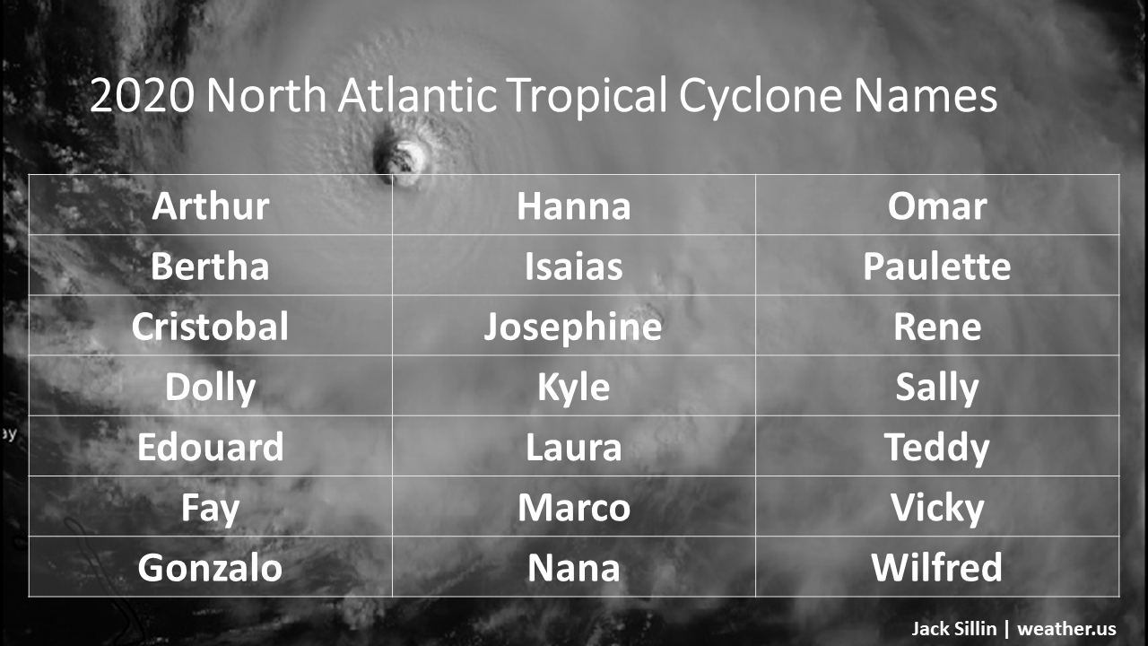
Any storm with maximum sustained winds greater than or equal to 40 mph is given a name from a list generated by the World Meteorological Organization (a branch of the United Nations). Six such lists exist for each basin, and a different is used each year. That means that every six years, a list is re-used. For example, earlier in May 2020, we had a tropical storm named Arthur. There was also a storm named Arthur in 1984, 1990, 1996, 2002, 2008, and 2014. There is one exception to the reuse of names which is that if a storm is particularly destructive, its name may be retired by the WMO. This means that it will be moved out of the rotation and replaced with a new name. Some examples of retired names include Sandy, Katrina, Andrew, and Matthew, among many others.
Storms with maximum sustained winds less than 40 mph are given a number which is simply a running count of the total number of storms that have formed in the system’s basin during the current season. For example, the fourth tropical cyclone to develop in 2020 will be given the designation Tropical Depression Four unless it has maximum sustained winds in excess of 40 mph at the time it meets the criteria to be a tropical cyclone. If that’s the case, it will “skip” the tropical depression classification and move straight to Tropical Storm Dolly.
Here is the list of names for the 2020 North Atlantic hurricane season. We’ve already seen Arthur come and go, so the next storm to develop will be Bertha, then Cristobal, and so on. You’ll notice that the list ends at “W” which is not a typo. The North Atlantic only gets 21 names each year, because the odds of exceeding that number is very small (it has only happened once since tropical cyclone naming began in 1953) and it’s unsurprisingly hard to think of enough names that begin with X, Y, and Z. The Eastern Pacific gets those names because, on average, more cyclones develop in that basin.
In the rare event that more than 21 tropical cyclones form in the Atlantic in any given year, subsequent storms will be named after letters in the Greek Alphabet. This occurred in 2005 when tropical storms Alpha, Beta, Gamma, Delta, Epsilon, and Zeta developed. Beta and Epsilon became category two and category one hurricanes respectively.
That’s just about all there is to say about the classification and naming schemes for tropical cyclones in the North Atlantic (and, with a few adjustments, around the world). Be sure to check out the rest of the Tropical Cyclones 101 series for more info on tropical cyclones.
-Jack
