Three-Part Storm To Impact A Wide Swath Of The US In The Last Few Days Of 2019
Hello everyone!
A complex storm system will impact most of the US over the next several days as it develops and redevelops three times. This post will briefly outline the storm’s overall trajectory while other posts (linked below) will discuss each part in more detail. This system’s impacts look to be primarily winter-weather related, though some flash flooding and severe thunderstorms are possible especially with the first and second iterations of the system.
Phase one details: click here.
Phase two details: click here.
Phase three details: coming later this evening.
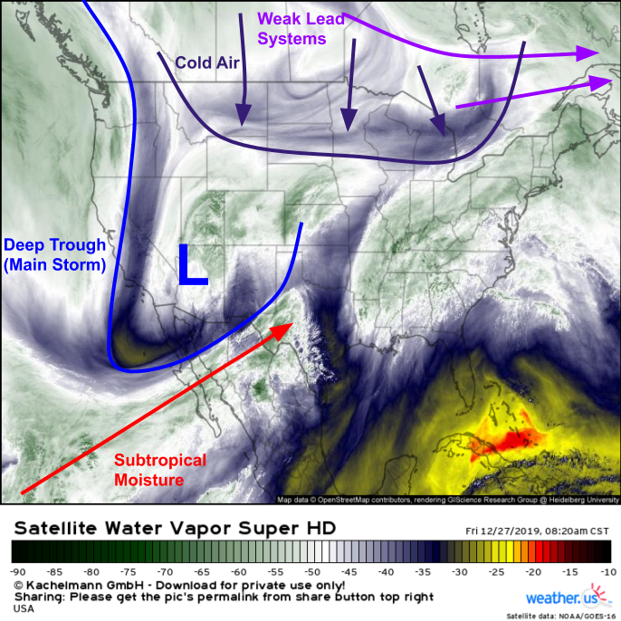
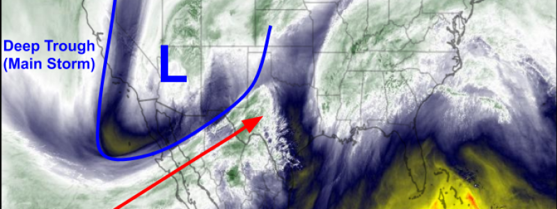
This morning’s WV satellite imagery from GOES-East highlights the pattern setting up the first phase of the storm. A deep trough is moving east through the Rockies with a mid/upper level low centered over Arizona. This is the first phase of the system, referred to as the “main storm” as its development will support the second and third phases later this weekend. This system is tapping into some subtropical moisture from the Eastern Pacific, which means it will be able to produce decently heavy precipitation even before it taps into moisture from the Gulf of Mexico tomorrow. As a result, heavy rain and snow is already ongoing in parts of the Southwest and southern parts of the Intermountain West. Farther north, an assortment of weak storm systems is moving east through Canada. While there’s no true Arctic air to be seen over the North American continent (outside perhaps of Alaska), the polar air associated with these systems will be just enough to support snow and ice on the northern side of the first storm as it develops tomorrow.
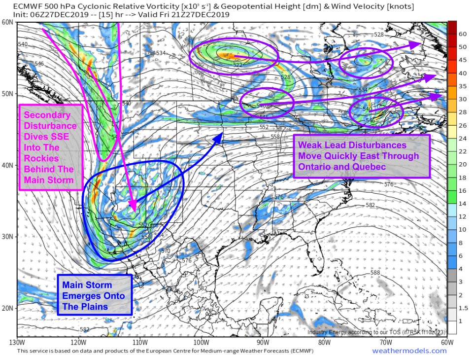
This is what the mid/upper level pattern is expected to look like by this afternoon. Highlighted in blue is the system we’re currently tracking through Arizona. Another system, not visible yet on the CONUS WV imagery, is highlighted in pink and will be diving south-southeast into the Rockies from Canada. This is the disturbance that will be responsible for powering the second phase of the storm beginning on Sunday. Meanwhile, the series of weak disturbances we saw over Canada will continue to move swiftly east, lazily pushing cooler air into the Great Lakes.
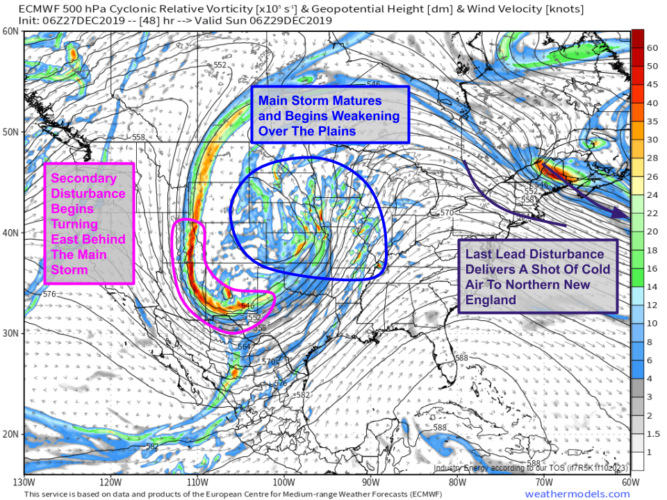
By tomorrow night, the first phase of the storm will be reaching its peak intensity over the Northern Plains where heavy snow, strong winds, and some ice can be expected. More details on that phase of the storm can be found here. Meanwhile, the secondary disturbance we’ll see digging into the Rockies today will near the US-Mexico border in New Mexico, where it will begin turning to the east. That will set the stage for the second phase of the storm to ramp up later on Sunday. Meanwhile over New England, the last of those weak disturbances we’re watching over Ontario today will take a dive to the south. This disturbance will drag a surface cold front along with it, which will set the stage for the last phase of the storm Monday into Tuesday.
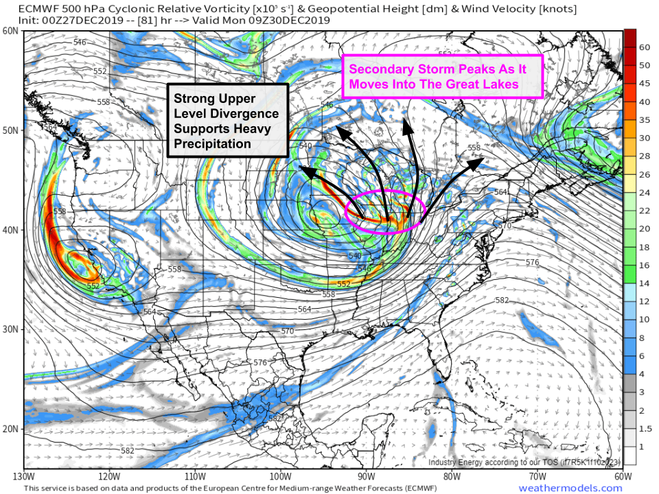
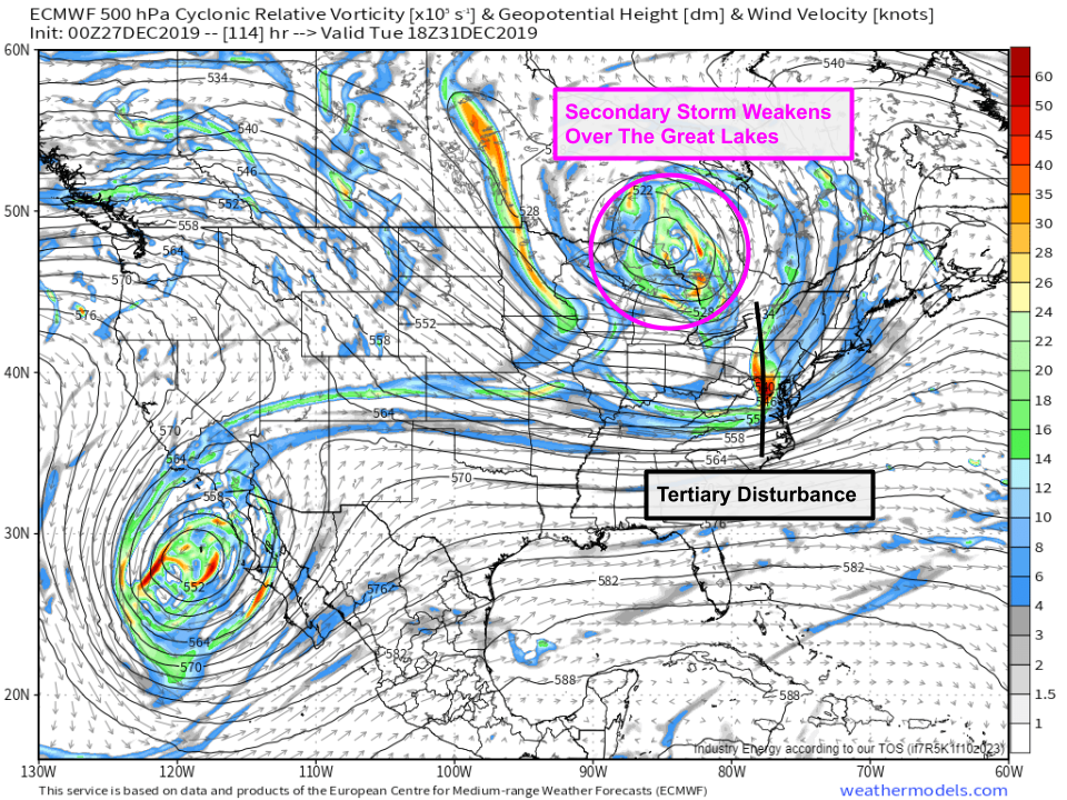
Early Monday morning, the second phase of the storm will peak as it tracks from the central Mississippi Valley into the southern Great Lakes. Strong divergence in the mid/upper levels of the atmosphere will help this phase of the storm produce bands of very heavy precipitation across the Great Lakes. More information on phase two of the storm can be found here. Though it’s not obvious at this point in the forecast evolution of the storm, some of the energy released during phase two’s development will make a full lap around the larger trough (centered over Iowa) and go on to fuel development of phase three on New Year’s Eve. One last item to note on the forecast map above is the trough moving south towards the crown of Maine. This is another reinforcing shot of cold air that will help support phase three’s wintry side, though it’s not exactly certain how far south that disturbance (and thus the cold air) will be able to move before phase two’s warm air begins encroaching from the west.
As I mentioned before, some of the energy released by phase two’s development will coalesce into a third disturbance which will rotate around the base of the larger trough on Tuesday. Depending on this feature’s exact track and strength, a third area of low pressure (“phase three” of the storm) will form off the New Jersey coastline before moving northeast into the Gulf of Maine. It remains to be seen just how strong this part of the storm will be, but early indications are that this last phase of the storm will be much less intense than the first two systems over the Central US. More information on phase three and its impacts can be found here.
The ECMWF 500mb vorticity maps in this post are available at weathermodels.com.
The entire system will move east into the Canadian Maritimes by Wednesday night. For information more relevant to the part of the storm expected to impact you, please refer to the other posts linked here. For information specific to your town, head on over to weather.us and type your town’s name into the search box for detailed forecast info.
-Jack
