The Tropical Onslaught Continues
Hello everyone!
We have not one, not two, but three tropical systems to watch for this morning, each of which either is impacting or could impact the US. Of course the first storm is Harvey which continues to impact Texas and will begin to move east towards Louisiana today. The second storm is Potential Tropical Cyclone Ten which will move ashore as a tropical storm in North Carolina. The third system is just off the West African coast, but forecast models are in nearly unanimous agreement that it will strengthen into a hurricane and move west towards the US. It’s far too early to tell exactly where it will track or exactly how strong it will get, but we can get some clues which we’ll go over.
Let’s start with Harvey as it continues to flood the Houston area.
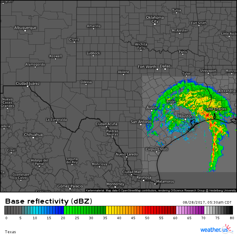
HD radar data shows the heaviest firehose of moisture moving east into Louisiana. How fantastic this is for Houston is hard to overstate. That band is where the torrential downpours are located. Some mid level dry air is moving into the Houston area which is shutting off the worst of the downpours. However, different atmospheric processes are taking over. Moderate rains are developing over the Houston area this morning as you can see on the radar image. These moderate rains extend all the way back to San Antonio and will continue through the next several days. Some of those torrential downpours could redevelop as the storm tries to regain a little of its former strength over the Gulf of Mexico.
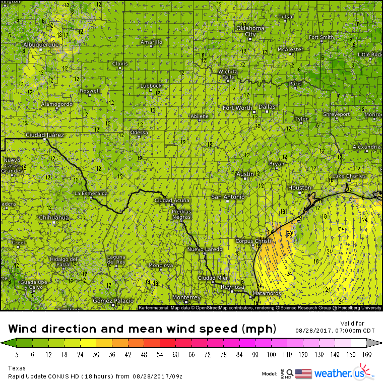
This is the HRRR model showing Harvey’s center moving back offshore today. Based on some radar trends it may already be there. Harvey’s circulation has stirred up the waters in the Gulf of Mexico and Water Vapor satellite loops are showing drier air working into the system from the southwest. Both of these factors will keep a lid on Harvey’s strengthening potential today and into tonight.
When will Harvey finally leave Texas alone? Perhaps sooner than we thought.
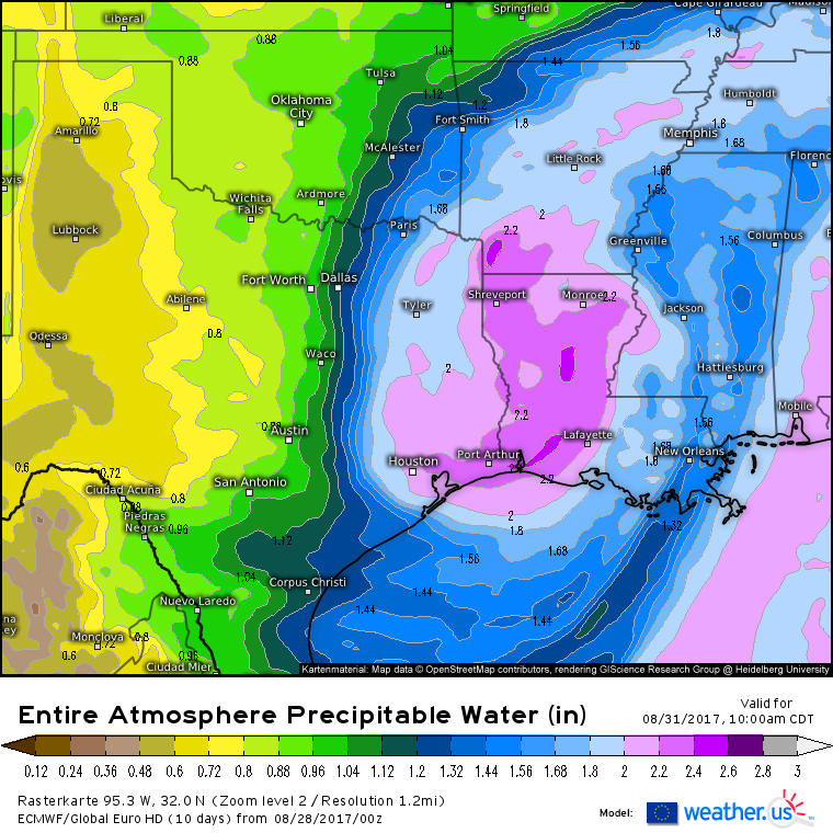
By Thursday, the ECMWF’s moisture forecast shows the center of the storm over Louisiana with much drier air streaming into the Houston area from the northwest. This would result in torrential rains tapering off to showers and eventually clearing out altogether by the weekend so that recovery efforts can begin. This is absolutely a marathon, not a sprint for these areas. That being said, recent forecast trends are looking MUCH better as compared to a couple days ago.
You can follow Harvey with GOES-16 Satellite imagery, HD radar imagery, and high resolution model runs, all at weather.us. For each of these maps, you can explore the menus to the left of the image to find additional settings and information.
Farther to the east, Potential Tropical Cyclone 10 is continuing to organize just East of Florida.
Our first GOES-16 visible satellite images of the day show continued disorganization of the system as it experiences fierce upper level winds fueled by outflow from thunderstorms in Harvey. That being said, there are some signs of a circulation developing in the Jacksonville area and the presence of that circulation combined with the thunderstorms near the center could be enough for the NHC to classify this system as a tropical storm at some point today.
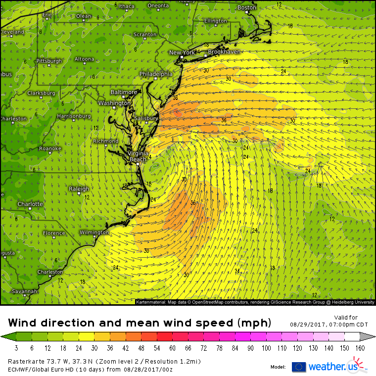
So where is this storm headed? It will move northeast tonight and intensify into a low-end tropical storm. Tropical storm force winds are expected to impact eastern North Carolina, parts of the Virginia Beach area, and areas farther north towards the Delmarva. Gusty winds could extend all the way up into New Jersey before the system makes a turn to the east on Wednesday.
Notice in the ECMWF’s wind speed and direction forecast the direction of some of those strong winds. They’ll be out of the northeast, and this will push water from the Chesapeake Bay and from the Atlantic Ocean into the Virginia Beach area. Parts of Norfolk and Virginia Beach that are susceptible to flooding will likely see minor to moderate inundation as the storm moves away. Current estimates are for storm surge values in the 2-4 foot range which, while not extreme, will certainly be enough to cause disruptions. The most likely time for this will be the Tuesday afternoon high tide with a secondary peak occurring during the high tide early Wednesday morning.
In addition to the wind and the surge, some heavy rains are expected as the system moves through.
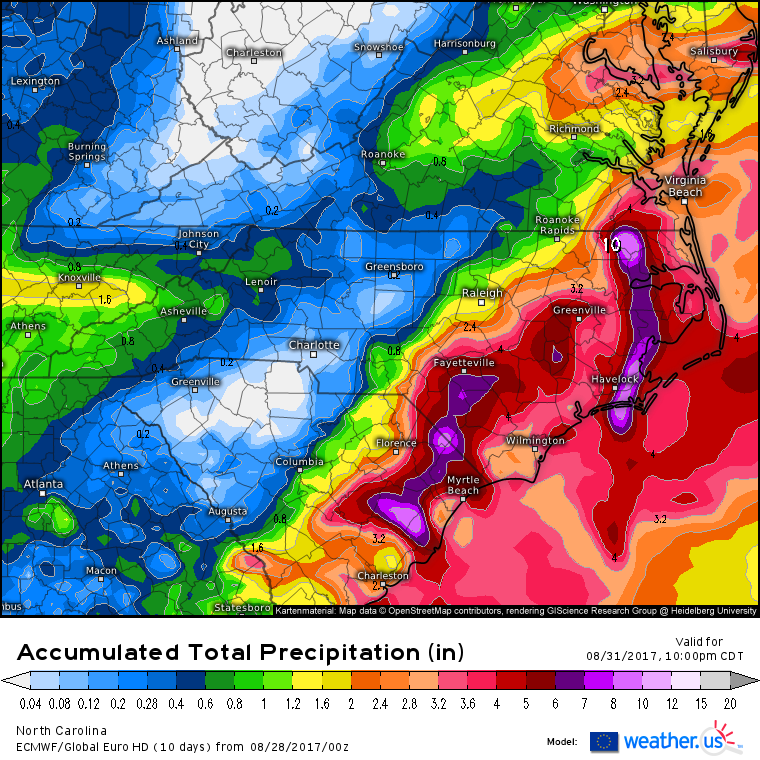
A widespread swath of 2-4″ of rain is likely from Coastal SC all the way up through Raleigh and the Delmarva. Farther east, along the more immediate coasts of NE SC and E NC, amounts in the 3-6″ range will be expected. Some pockets in excess of 6″ are possible if banding sets up in the same places repeatedly, but the fast motion of the storm will ensure that we don’t see any ridiculous totals. Notice that this setup is exactly the opposite of Harvey where the storm’s very slow motion resulted in extreme rainfall. Thankfully, that will not be the case with PTC 10 which should become TS Irma later on today.
The storm will move east away from the region on Wednesday and while the rest of the Northeast US coast won’t see much in the way of direct wind/rain impacts, the ECMWF’s wave model shows swells from the storm causing high surf and the potential for rip currents along the entire East Coast through the latter part of this week.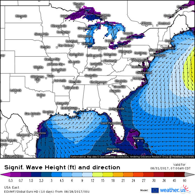
After several consistent model runs, we now have a third system to keep a close eye on. It’s currently thousands of miles away from the US, but there are strong signals that it could pose a threat to us at some point down the line. It’s too early to say how strong it could get, or where if anywhere at all, it may make landfall, but I did want to briefly go over the setup to show you why this is worth watching closely in the days to come.
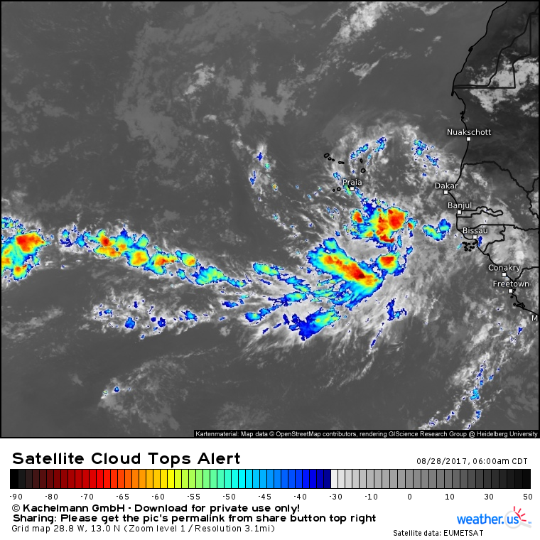
Satellite loops of the system show a very healthy tropical wave. There’s a cluster of thunderstorms that is present over the center, and the tops of those thunderstorms are fanning out in all directions, indicating a shear-free environment. So what’s ahead for this system?
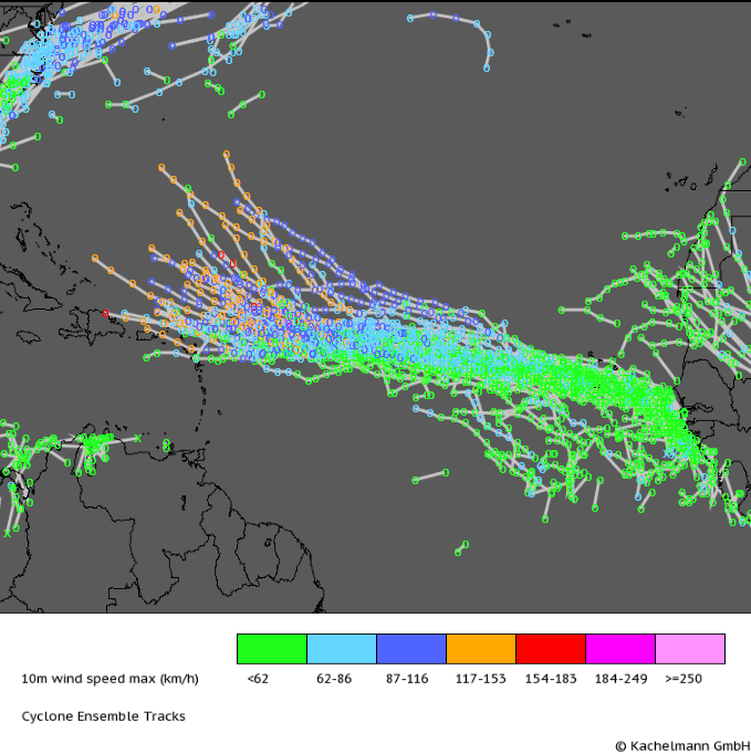
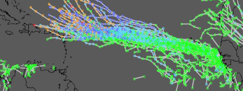
A look at the ECMWF ensembles shows why I’m concerned about the storm and want to tell you about it now. A mere 8 out of the 51 ensemble members keep this storm below hurricane strength as it moves WNW across the Atlantic.
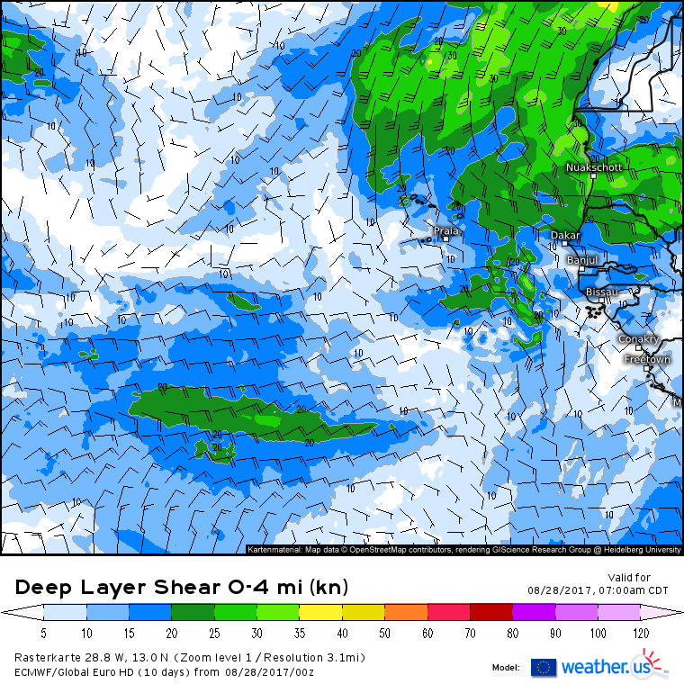
The storm’s environment will continue to be extremely conducive to development as it sits in an area of very high moisture and very low wind shear.
In fact, there’s going to be a “negative wind shear” setup where diverging winds aloft help to vent the system. This is the same process that allowed Harvey to strengthen and organize so rapidly. While it’s far too early to say if the system will make landfall on the US coast, do notice that nearly all of the ensemble tracks above have the track pointed in the general direction of the US coast. A strong Bermuda high is something I’ve been talking about since early July as a risk for possible tropical impacts here and the US, and that pattern has already delivered with Harvey’s landfall a couple days ago. Hopefully it won’t deliver again with this latest system, but we’ll certainly be watching closely in the coming days.
You can keep tabs on this system using satellite data from the EU-METSAT satellite as the system is currently too far east to be seen by GOES-16. Curious about the storm’s potential future track/intensity? Compare model guidance to see what the different models think. An easy way to do this is to use the small blue buttons at the top of the image to select the same output for the same time, but from different models. Since any potential US impacts would be about two weeks from now if they happen at all, don’t take any one model solution too literally. It’s likely to change quite a bit as the storm slowly drifts across the Atlantic.
I’ll have many more updates on this storm as it continues to develop this week.
-Jack
