The Planetary Boundary Layer
Hello everyone!
Recently we just added a neat new parameter to weather.us, which displays the forecasted height of the Planetary Boundary Layer at a given time. So what is the Planetary Boundary Layer (PBL for short) and why is it important? This post will answer those questions, and hopefully give you a better idea of what you’re looking at on our PBL maps.
In simplest terms, the PBL is simply the bottom layer of the atmosphere that comes in contact with the surface of the earth. See if you can pick out the top of the layer in the image to the left, which depicts a fog bank.
So how do we know where the top of the PBL is? The answer to that question comes down to some of the characteristics of the layer we define as the PBL. The top of the PBL is just wherever the air stops exhibiting those “near surface” characteristics. Frequently, there’s also an inversion (area where temps warm with height) at the top of the PBL The most important characteristic of the PBL is vertical mixing of air within the layer. That means that a parcel (small “chunk”) of air at any elevation within the layer could easily end up at any other elevation without the intervention of some outside lifting/sinking mechanism. Once you get to an altitude so far above the ground, that air parcels would need some outside downward pressure to descend to the surface, you’re out of the PBL.
Because any air parcels within the PBL are subject to interaction with the surface at any time, they’re also subject to the effects of friction. As a result, winds within the PBL are generally weaker than those farther up in the mid levels. However, because of the vertical circulations discussed above, strong winds near the top of the PBL can be “mixed down” to the surface.
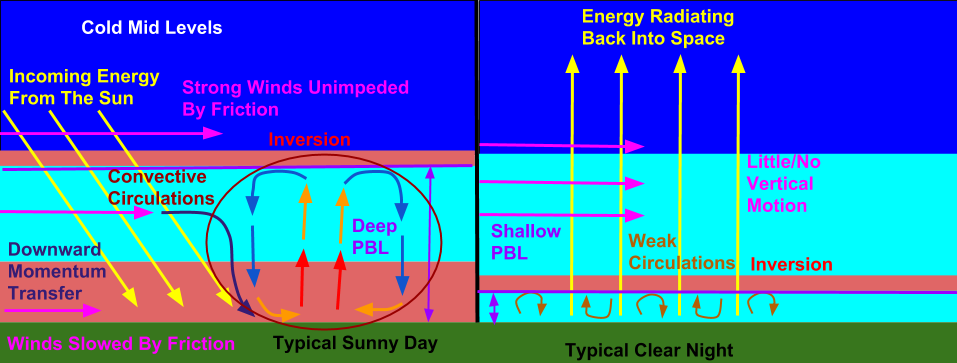
Another very important part of the PBL is its diurnal cycle. The schematic below illustrates how the lower atmosphere changes from day to night.
The left panel shows an idealized representation of the atmosphere on a clear day. Incoming energy from the sun heats the ground, which heats the air near the surface. This warm air then rises, gently cooling as it does so. At some point, it’s no longer warmer than its surroundings (because of the inversion), so it sinks back down, forming a convective circulation. This sets up the vertical mixing we talked about above.
At night, the energy tendency at the surface reverses. Instead of the sun heating the surface and the adjacent air, energy is radiating back out into space, resulting in cooling. Because the air just off the surface doesn’t cool as fast, the inversion that was present several thousand feet up is now barely off the ground. As a result, the convective circulations disappear, and there’s very little vertical mixing. The PBL then becomes very shallow, and occasionally can for all practical purposes disappear entirely.
Here’s a look at the real life results of the processes discussed above. This map is the forecast for PBL heights at 7 AM Eastern Time, right when the sun is coming up over the Eastern Americas, but after Western Europe and Africa have had several hours to heat up. Therefore we can compare what the PBL looks like during the night (over the Americas) to what it looks like during the day (over Europe/Africa). Note the higher PBL values in areas with daylight compared to those still in the dark of night. You can see there are some exceptions though, particularly over the Central and Eastern US. Because all you need for a deep PBL is vertical motion, if you have a storm nearby, the storm’s dynamics can produce vertical motion and mixing that overcomes nocturnal stability.
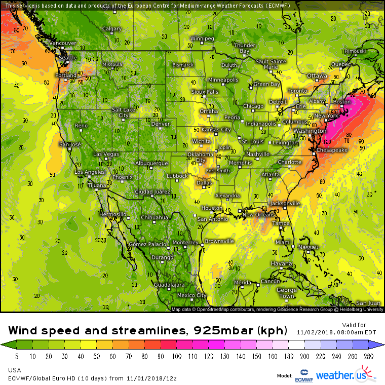
Checking in on lower atmospheric winds at the same time, we can see that the areas of stronger winds in the Central and Eastern US line up well with the areas that have higher PBL’s despite the lack of daytime heating. PBL heights are higher over the ocean, and have less diurnal variability, because there’s very little friction over the ocean, and the sea surface temperature changes very little from day to night as it takes much more energy to warm water than air.
So why is it helpful to know the height of the PBL besides being able to figure out the time of day? Knowing how much vertical mixing is present in the atmosphere is important for forecasting all sorts of things including turbulence, wind, and air pollution. You can also use the PBL to forecast temperature independent of the default model 2m temperature maps in some cases.
Hopefully this has helped you learn a little more about the PBL, what it is, and why it might be important. Enjoy exploring all the new maps, and next time you have a particularly bumpy takeoff on an airplane, think of the PBL and its vertical mixing.
-Jack

