The Grip of a Megadrought, Part 3: A Slow, Violent Burn
Heat is pervasive, searing, angry. It swells and crashes over us like waves, smothering and suffocating and crushing. If cold is a knife, heat is a hammer.
This week, from Los Angeles to Redding, Las Vegas to Boulder, Phoenix to Billings, the hammer stalks and stifles.
Heat and drought are two sides of the same coin. Extreme heat speeds evaporation from reservoirs, soil, and any remaining snowpack. Less moisture in soil also increases extreme heat risk by allowing relatively dry near-surface air, which heats up faster than ‘wet’ air with less energy being partitioned to evaporation. This hotter air can then speed evaporation further. It’s an example of a feedback cycle, which can deepen drought conditions during a dry season if conditions support heat and if the preceding wet season left the region anomalously parched. The process is on full display this week, as record heat made possible by near-record low soil moisture further dries the ground, sending the drought careening ever deeper.
Over the past few days, I’ve written about the challenging decades and the disastrous year that have pushed the West into a state of dramatic and widespread drought, a new chapter in a long-duration ‘megadrought’. Now, following a lackluster winter and nonexistent monsoon, the region sinks into a dry season, and the near future appears grim.
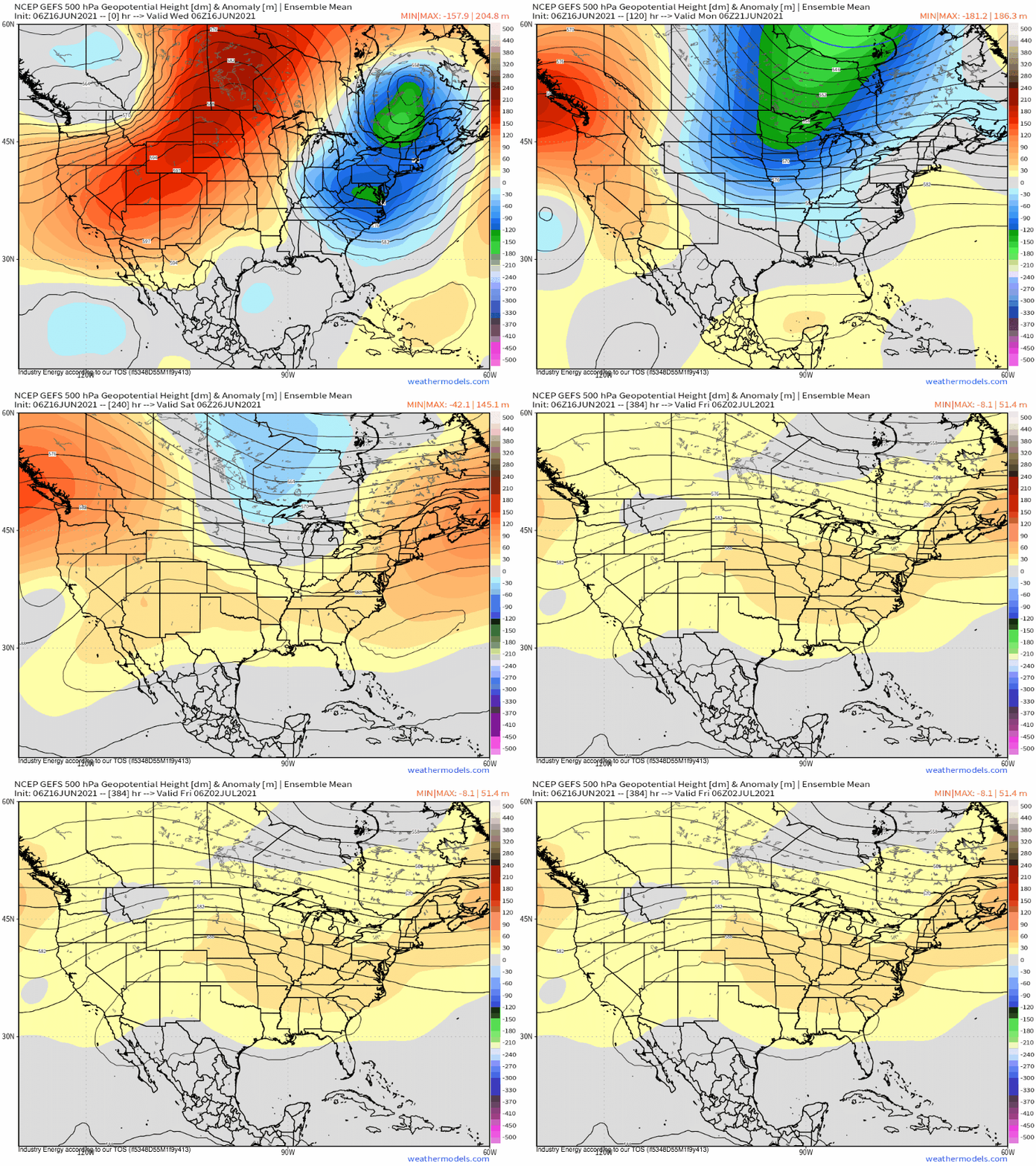
The ridge currently baking the West will wax and wane with time, but should remain largely intact for at least the next couple weeks. Ensemble models, which average dozens of different supercomputer runs to generate a fairly reliable atmospheric picture as far out as two weeks, depict midlevel heights higher than average to persist almost wholly through the end of the forecast period over much of the West.
This type of mid-atmospheric environment is quite supportive of anomalous heat, which should be unusual in ferocity due to the parched soil, and should also continue to dry the soil further. Sound familiar?
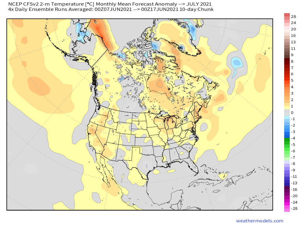
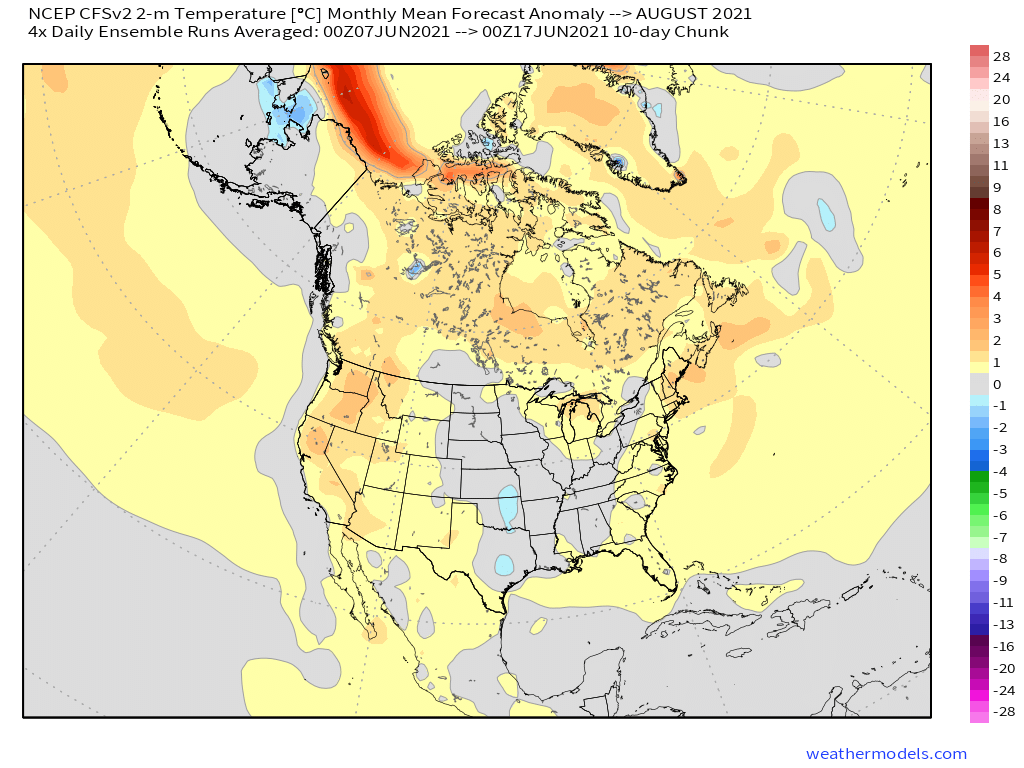
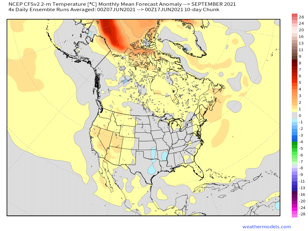
Extreme heat over the West will be commonplace this summer, with near certainty. Soils are some of the driest they’ve ever been, which means the often stifling regional heat will probably be nudged upwards in frequent record-challenging heatwaves. Heat is dangerous to people and animals, and I wouldn’t be surprised if one of the most disastrous ‘weather’ events of the summer is the West’s heat. The heat will also encourage evaporation, drying reservoirs and soils further. The CFS model, which averages dozens of long-range models to generate a smoothed image of broad atmospheric regimes months in the future, depicts temperatures significantly warmer than average across the West in July, August, and September, months climatologically prone to extreme heat.
As the season wears on, the downward spiral of extreme heat and dry soil will likely incrementally worsen drought over the West as reservoirs deplete and the earth loses some of what little moisture remains. Dead plant matter will also continue to dry, aided by the anomalous, partially drought-driven heat and parched air. This process is already leading to unusually early wildfire growth in parts of the West, a process likely to continue to expand in scope. By the late summer, an explosive wildfire season that could rival the unprecedented years past seems possible at the confluence of historically poor forest maintenance and months of unusually dry, hot air.
Many have been comparing this year’s potential wildfire season to 2020, a year that shattered so many records. At the level of drought and fuel seen last year and this year, wildfire risk really only depends on atmospheric wind drivers and ignition sources. In 2020, an unusually powerful offshore wind event driven by an intense and anomalously early season trough helped fan the huge Creek Fire, while an oddball lightning storm at the end of the summer ignited four massive complexes. Without these five giant fires, all of which were among the six larges in California history, the 2020 season would have been much less noteworthy. Let that demonstrate how finicky high-end wildfire seasons are: had it not been for two very unusual atmospheric events, last year would not have shattered records the way it did. It follows that, while the base conditions are once again very favorable for Western wildfires, we really can’t say how the fire season will stack up against the last few years, because, at the hands of the megadrought, many years past also had very favorable base states. This fire season will probably be very bad. Just how bad depends too much on what the atmosphere may do, day to day, in the coming months to predict exactly.
Just because something is months away, though, doesn’t mean we can’t forecast for it. Enter the 2021-2022 Western wet season.
I’ve sort of tossed reservoir depletion concerns aside thus far. At present, almost every major reservoir in California, the most populous state under ‘exceptional’ drought, is between 30% and 60% full. At this point in the year, some level of drying is expected, but not to this extent- all but one of the state’s 12 major reservoirs are below daily average, with some as low as 40% of this average. Water allocations to farmers in the state have been slashed as a result, and Californians everywhere have been encouraged to conserve water, but no major population centers are experiencing water shortage ’emergencies’ at present. This could well change if the 2021-2022 wet season is as dry as the last two have been, especially for Northern California.
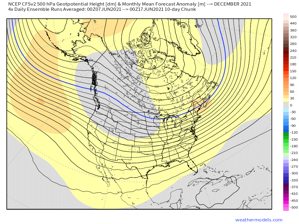
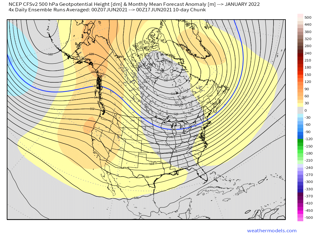
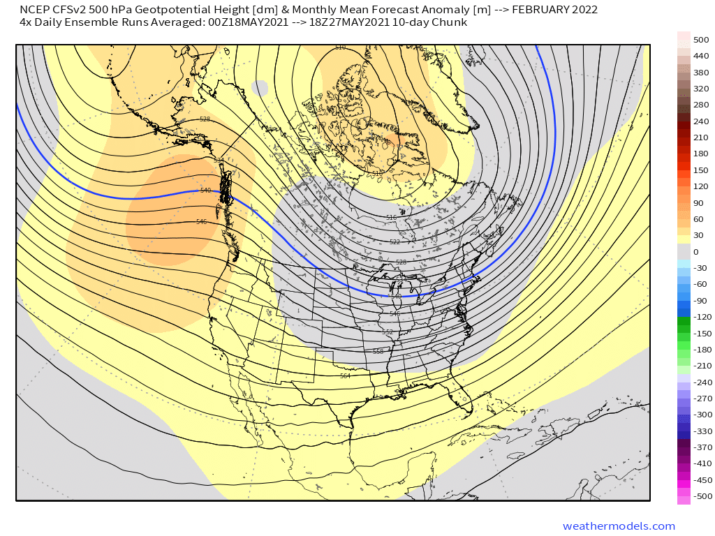
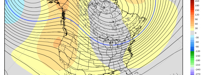
There’s a lot of pressure on this year’s wet season, then, to either deepen or lessen deficits everywhere from Washington to New Mexico, California to Montana. As you read about in the first installment of this series, the ‘wetness’ of a wet season largely depends on the presence of persistent offshore ridging. To determine the odds that such ridging will once again rule the winter, we can once again turn to seasonal models. The picture they paint is not pretty.
Ridging of the type shown by the CFS would disallow any type of persistent atmospheric river development. This pattern would support another anomalously dry wet season, which would push the West yet deeper into an increasingly dangerous drought.
Of course, predicting the future is hard, especially so far out, and climate models can be hit or miss. But resilient ridging has been quite common recently, showing up over the winters of 2013-14, 2014-15, 2015-16, 2017-18, 2019-20, and 2020-21. Should something larger than seasonal be driving this recurring ridging, it would make sense to expect this smattering of anomalies to continue.
In fact, a fair amount of work has been done to uncover the forcing mechanisms behind persistent ridging, with a building consensus that anthropogenic climate change (ACC) is making such wintertime E. Pacific events more common (Source 1, nonscientific but incredibly informational source 2, which itself lists several scientific sources). It seems, based on models and observational data, that there is an increasing tendency for a ‘warm west, cold east’ pattern likely tied to human-caused global warming, as Western North America warms faster than the East, possibly caused by the jet variability in the latter compared to the former. This warming segregation could enhance the feedback that promotes longwave ridging and troughing, which corroborates a couple decades of unprecedented winter activity near the I-95 corridor, as well as increasingly persistent E. Pacific seasonal ridging. Here, a possible ACC-driven atmospheric factor behind the resilient ridges off the West Coast is possible.
There is also a possible connection between warming Pacific SSTs and the feedback cycles that promote ridging there. As ACC leads to a warming ocean, a number of jet anomalies including the tendency for resilient ridging become more likely. Of course, within this warming regime, random variation leads to years that feel ‘lucky’, like 2016-17, and ‘unlucky’, like 2020-21. Like with fire weather, we can tell the West is set up for a bad time, but the specifics are impossible to nail down. But one thing is clear: the system is increasingly rigged towards drought, and in the long run, the house always wins.
Heat and drought are two sides of the same coin. A warming atmosphere, and the cascading impacts on important circulations, likely spells continued trouble for the West over the coming decades. As this forcing increasingly influences the Pacific atmosphere, it takes more seasonal ‘luck’ to get a wet season than a dry season. Finally, we can see: this is how the megadrought was likely born. And, through increasing forcing from ACC alongside periodic bad luck, it will probably continue to propagate.
The US Drought Monitor’s weekly update was published today. The fraction of the West in a state of drought has gone up yet again, breaking a record set last Thursday.
This has been the last installment in a three-part series on the West’s medadrought, which I consider to be the defining weather event of my lifetime thus far. I encourage you to read part 1 and part 2, if you have not already.
