TD 8 Forms In The Gulf Of Mexico, Gonzalo Struggling With Dry Air East Of The Windward Islands
Hello everyone!
Today’s tropical update will discuss newly-minted TD 8 in the Gulf of Mexico (which formed from the disturbance 91L we were watching yesterday) and Gonzalo which is currently struggling with dry air east of the Windward Islands. You might recall from yesterday’s update that we were also watching a wave just emerging off Africa for possible long-range development. While that feature is still worth keeping an eye on, there’s no change to the going forecast as of this morning. We’re basically going to be watching and waiting for another 3-5 days before we start giving that feature a closer look.
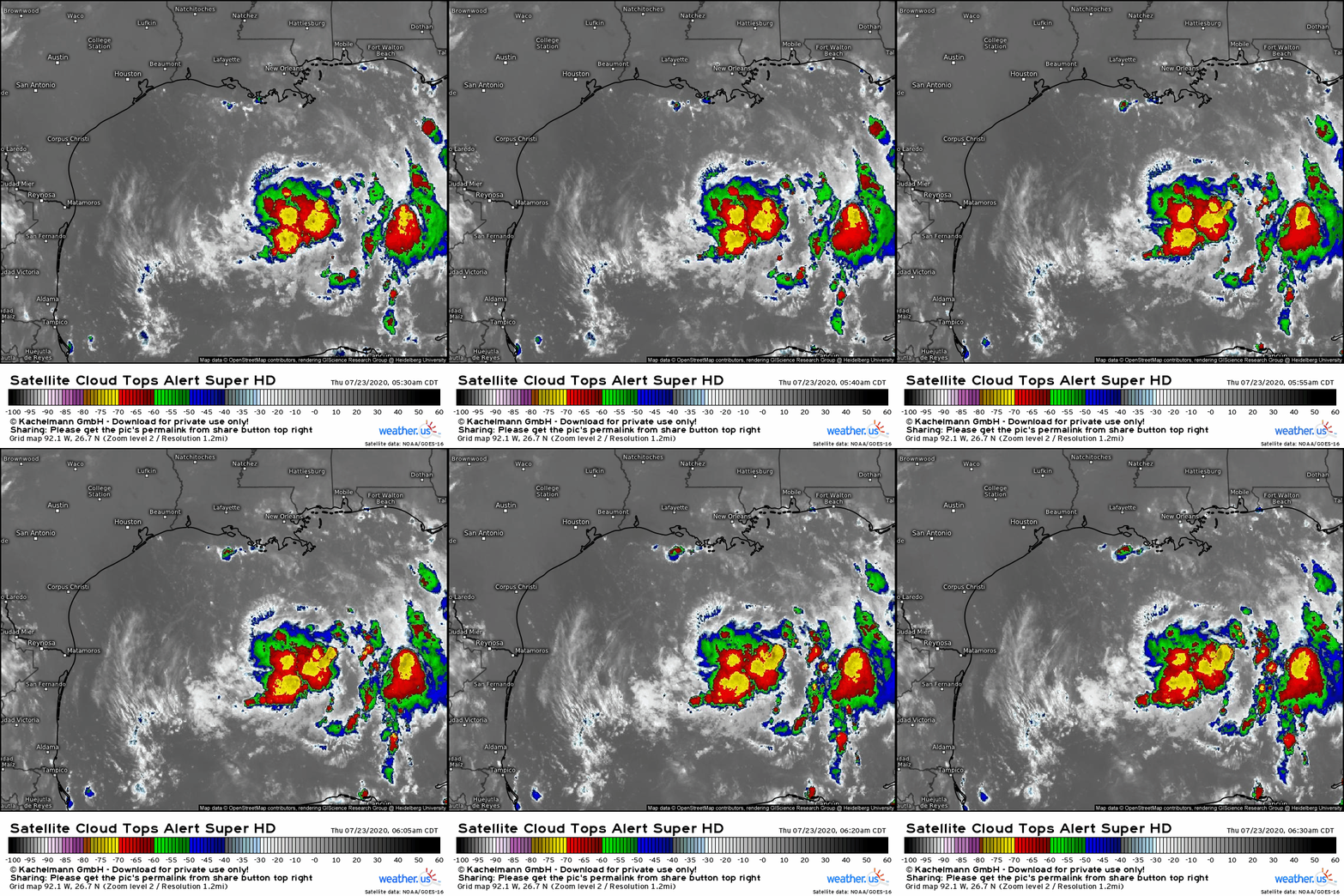
TD 8 is currently looking rather healthy on satellite imagery. The system has a cluster of intense thunderstorms near its center and upper-level outflow is spiraling away from the center in a textbook clockwise spiral. While there is not yet any sign of a consolidated “inner core” ring of thunderstorms surrounding the center, I wouldn’t be surprised if such a feature develops later today.
The environment will be quite conducive to intensification if TD 8 can get its inner core in order. The upper-level anticyclone currently helping vent the system and protect it from shear will continue moving westward above the storm’s center. Dry air will remain a minimal concern and sea surface temperatures are more than warm enough to support intensification. TD 8 will only be held back by its own disorganization and limited time over water (it has 36-48 hours left to strengthen). Yesterday, I mentioned that the most likely scenario would be landfall in Texas as a weak/mid-grade tropical storm. In light of recent organizational trends, I think the odds of a stronger landfall (mid/strong TS) have increased. There is an outside chance that this really tries to take off and make a run at hurricane status if the inner core can consolidate today. I’d put those odds at perhaps 20-25%; not high enough to be imminently concerned about, but nevertheless a possibility that can’t be entirely discounted.
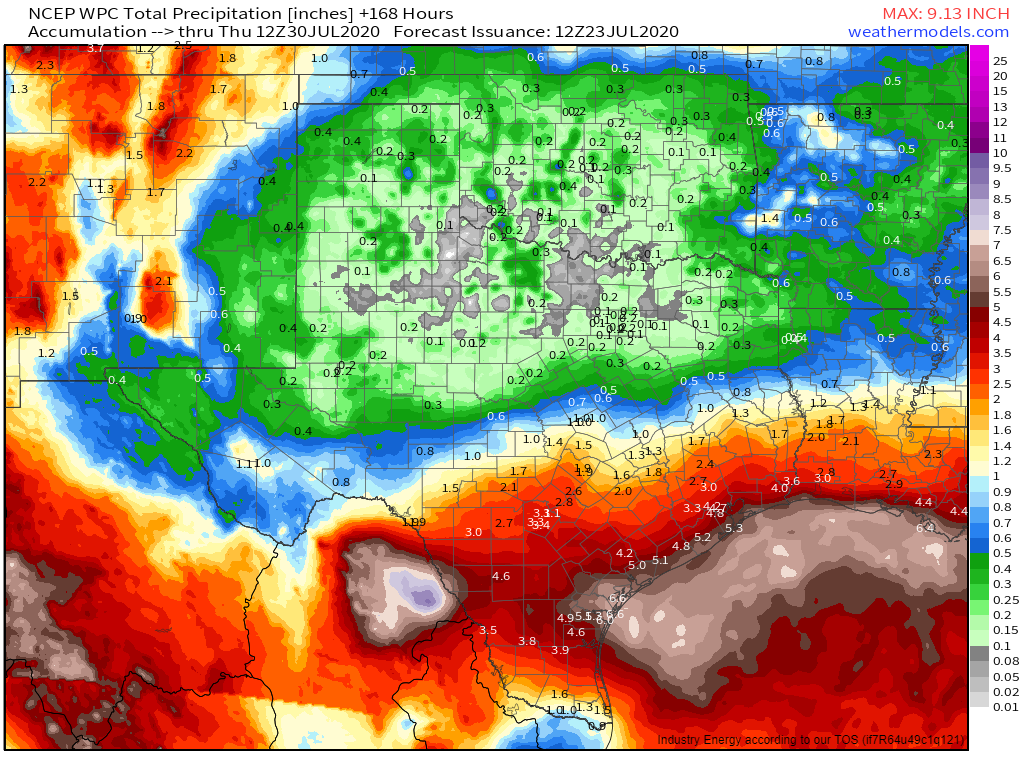
Regardless of TD 8’s final intensity at landfall, its primary impact will be flooding rains in southern Texas. Much of the state south of I-10 and east of I-35 can expect 3-6″ of rain with locally higher amounts especially near Corpus Christi. While no major river flooding is expected, smaller streams will expand beyond their banks and spots usually prone to poor drainage flooding will experience high water conditions. If your area is susceptible to flooding, begin your flood preparations now.
Out in the deep tropics, Gonzalo is struggling against a surge of dry air this morning. While it appeared yesterday as if the system could make a run at hurricane status by today, the lack of persistent deep convection near the center suggests that such rapid intensification is unlikely. If Gonzalo is able to rebuild its central dense overcast this afternoon, it could still attain hurricane status (maximum sustained winds >74 mph) tonight or tomorrow. That said, the dry air currently plaguing the storm isn’t going anywhere soon so it’s hard for me to see what would change in the next 12-24 hours that would promote re-strengthening for Gonzalo.
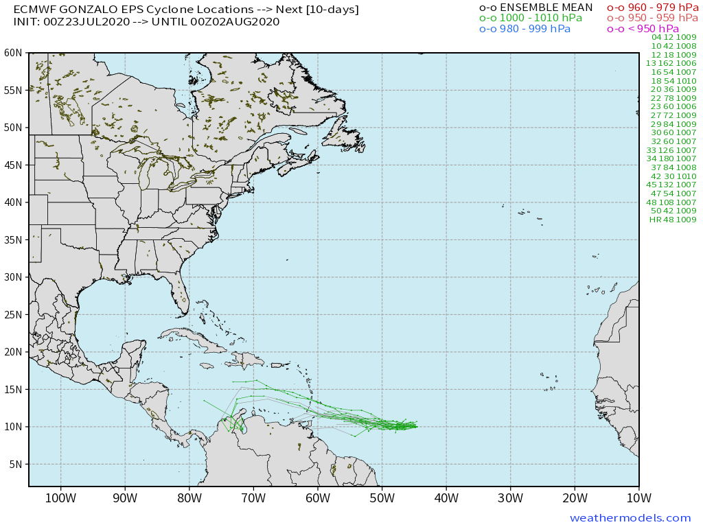
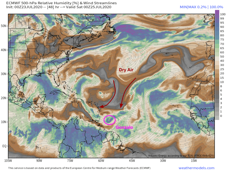 By tomorrow evening, Gonzalo will be faced with a renewed surge of mid-level dry air from the north. Unless the system can really get itself in order today, I think this is probably the death knell for Gonzalo, at least for a while. A well-organized hurricane with a strong inner core can fortify itself against dry air outbreaks such as this one, but a weak system has no such defense mechanism. While current official NHC forecasts take Gonzalo through the Windward Islands as a hurricane, I wouldn’t be surprised to see the system dissipate before it makes it past Barbados.
This idea is consistent with most EPS guidance which shows Gonzalo dissipating either before the Windward Islands, or not long after it arrives in the eastern Caribbean Sea. The system will return to favorable environmental conditions in the western Caribbean about a week or so from now. We’ll see if it’s able to take advantage and re-develop or re-intensify. At this point, the going forecast calls for no impacts to the mainland US. It’s still a little too early to completely write off the possibility that Gonzalo comes back to life in the western Caribbean and moves north towards the Gulf Coast, but at this point, that possibility seems quite remote.
Next update from me will be tomorrow evening.
-Jack
