TD 13 Becomes TS Laura East Of The Lesser Antilles, TD 14 Starts Making A Run At Becoming TS Marco In The NW Caribbean
Hello everyone!
Both TD 14 and now-TS Laura have been struggling for a variety of reasons today, but both are showing signs that they are trying to intensify this evening. The forecast for both systems remains uncertain (what a surprise!) because of their relatively disorganized state, their proximity to land, and their potential to interact with each other once they both reach the Gulf of Mexico early this coming week. That said, we have learned a bit more about what’s in store for each system. TD-14 now looks unlikely to fizzle over Central America, though it could very well remain on the weaker side as it moves NW towards the Gulf of Mexico. As for Laura? Well maybe we don’t actually know that much more than we did 24 hours ago. For a moment this afternoon, it looked like the system’s center had jumped south and significant land interaction was inevitable. Now it looks like the center might try to be jumping back east which would re-open the door for a track north of the islands. This post will outline the latest forecast information for each storm.
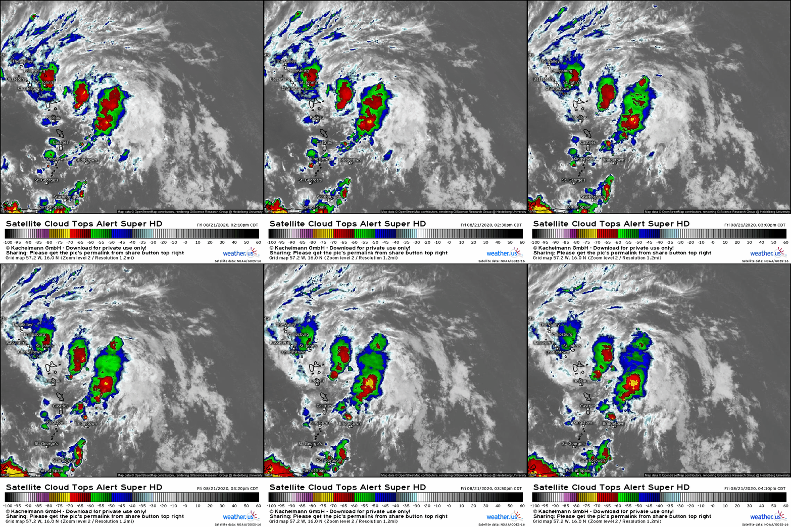
 TD 14 is the storm we’ve learned more about today. You can see it on satellite imagery spinning east of the Yucatan Peninsula and north of Honduras. The storm’s center is located under the burst of convection pretty much due east of northern Belize. That burst of convection is only about three hours old, but it could be key to determining if TD 14 continues drifting northwest as a TD/weak TS or if it rapidly intensifies into a hurricane. The fact that we’re seeing strong convection (cloud tops below -70C) developing over the small and compact low-level center during the late afternoon hours (DMIN) is concerning. That said, rapid intensification is a delicate process so while all the ingredients are there (as outlined in detail yesterday), there’s definitely an element of “believe it when you see it” involved here. If we end up seeing that convection persist over the center tonight, we could be looking at a hurricane by morning. If it fades like this system’s convection has done time and time again this week, not much will happen regarding the storm’s intensity.
So the near-term intensity forecast (today/tonight/tomorrow) will depend on the convective dynamics of those thunderstorms near the center. Unfortunately for those of us trying to predict this storm, and those in its path trying to figure out what to expect, these convective interactions are essentially random. I can tell you that the conditions are favorable for rapid intensification but I cannot tell you if these thunderstorms will wobble together in a way that boosts their intensity or if they will wobble in a way that leads them to fizzle out. If you’re located along the NE Yucatan Peninsula, you should be preparing for a hurricane landfall tomorrow night in the event that this does rapidly intensify. If it ends up fizzling out, you can breathe a sigh of relief.
The intensity forecast for Saturday night through Monday morning will relate primarily to how long TD-14 spends over the Yucatan Peninsula.
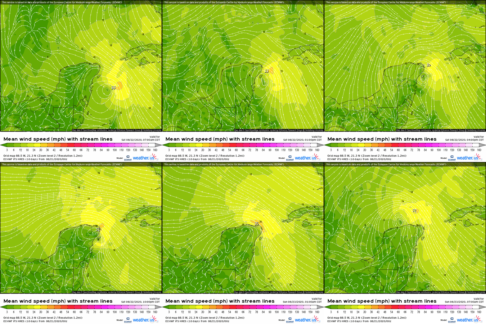
Most of today’s model guidance including the ECMWF shown here suggests that the storm’s center will just clip the northeastern tip of the peninsula Saturday night before re-emerging by Sunday morning. This would slow the system down a bit, especially if it were a small hurricane, but it wouldn’t be game over for the storm. The circulation would remain intact as the system emerged over the Gulf of Mexico, and if it were a small hurricane, the inner core likely wouldn’t be totally gone either. So while a wobble to the west would mean a slightly weaker storm and a wobble to the east would mean a slightly stronger storm, I think we can now rule out the scenario many models were depicting a couple days ago that took the system well west over the Yucatan Peninsula where it substantially weakened or even died out entirely.
TD 14’s intensity forecast from Monday onward will depend on its interaction with an upper-level trough over Texas, and potentially some upper-level outflow from Laura which will be speeding west-northwest towards the Gulf of Mexico.
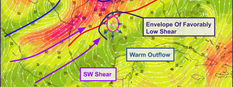
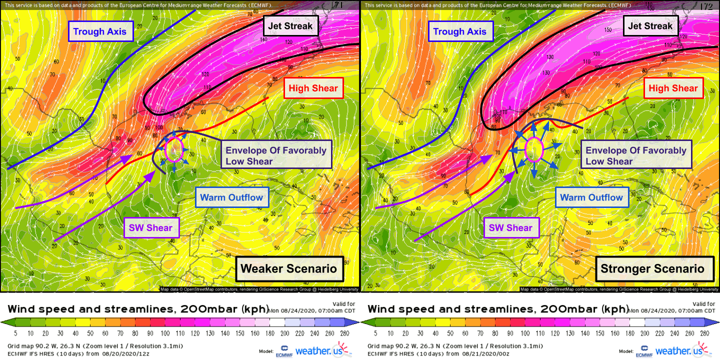 There are two general scenarios to consider here. The first is if TD 14 remains relatively weak or weakens over the Yucatan. In this scenario, the system wouldn’t generate enough convective activity and associated upper-level warm outflow to bulldoze a hole in the band of strong upper-level southwesterly flow ahead of a trough axis over Texas. As the storm moved north into that SW flow (a region of high wind shear because near-surface winds would be neither strong nor southwesterly), it would weaken further, and eventually make landfall probably as a weak tropical storm. This is currently shown by most global model guidance. The other scenario is if TD 14 becomes strong either over the NW Caribbean or over the Gulf of Mexico. If the storm were strong enough to be generating copious upper-level outflow, it could carve out an envelope of favorable conditions on the southern periphery of those strong upper-level southwesterly winds. The other boost for the storm in this scenario would be the westward extension of the upper-level jet streak over the Southeast. If the cyclone were to be placed in the right entrance region of that jet streak (which is the case in the stronger scenario much more than the weaker scenario), it would get an added boost from the upward motion associated with the jet streak dynamics. The net result would probably be landfall as a hurricane.
So which scenario is more likely? If I had to bet, I would put a couple bucks on the stronger scenario. The environment TD 14 finds itself in right now is so favorable, and it appears to be in the early stages of taking advantage. Rarely does one regret betting on a storm quickly intensifying in low shear over 30-31C waters in the NW Caribbean. Regardless of what scenario I personally think is marginally more or less likely, residents along the TX and LA coastline should be readying their hurricane plan and beginning preliminary preparations for potentially dangerous conditions Tuesday.
Out in the Leeward Islands, Laura is doing its very best to confuse us forecasters. The storm’s low-level center was initially located at the far northeastern edge of its convection yesterday. If that center were still in existence (it’s not), it would be north of Puerto Rico at the moment (roughly). This morning, hurricane hunters found a new center located farther south. If this center were still in existence (maybe it is, we won’t know until the next recon flight), it would be located near St John’s right now. This afternoon, convection has been most persistent ENE of Roseau where satellite imagery is hinting at the possibility of yet another new center. I was ready to adjust my forecast southward based on the first center relocation this morning, but now I’m not so sure. Here’s why the door might still be open to a track north of the islands assuming there is indeed a new center near that convection SE of St John’s and ENE of Roseau.
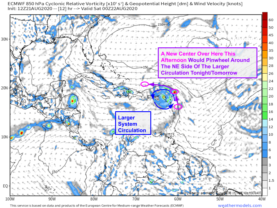 If a new circulation were to form on the eastern side of the current broad wave axis/circulation/whatever you want to call this thing (Laura?), it would be steered more north than west tonight as it pinwheels around the broader gyre centered farther west. With enough convective development, it could then drag the broader gyre north once it cleared Puerto Rico. Is this likely to happen? Honestly I don’t know. My first instinct is to say probably not. This scenario depends on a lot of things going “right” (from the storm’s perspective). A new center needs to actually form southeast of the current one, then it needs to be steered primarily by the larger gyre at least for the first 12 hours or so. Then it needs to develop enough convection to drag all that angular momentum northward and consolidate around a new center north of the Greater Antilles. For all of that to happen would require a series of delicate interactions that by pure statistical odds are somewhat unlikely to all happen successfully. So it’s a possibility that can’t be ruled out, but I don’t think it represents the most likely scenario at the moment.
So what is the most likely scenario? I think it involves Laura drifting along the very northern edge of Puerto Rico and Hispaniola over the next couple days before either continuing along the Cuban coastline or moving inland over Cuba. During this time, the system would struggle with dry air entrainment from winds downsloping off the islands on each mountain in addition to the issues caused by the friction produced by those mountains. This would preclude much strengthening of the storm until it reached the Florida Straits Monday afternoon.
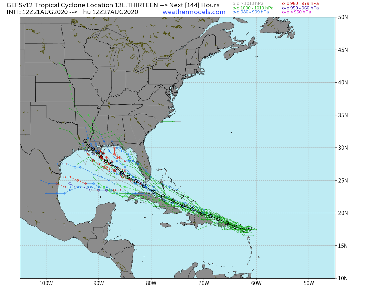
What happens then? Ensemble guidance isn’t exactly all that helpful in answering that question because the answer is too dependent on the nuances of how Laura interacts with the Greater Antilles. It’s possible the system is able to quickly strengthen once over the warm Gulf waters. The upper-level environment will be favorable for intensification (thanks to TD 14 pushing that trough out of the way) so I could absolutely see this becoming a hurricane by Tuesday. This is what the NHC is calling for in their official forecast. The most likely track would probably be towards Louisiana or Mississippi. That said, it’s also possible that the system is too damaged by tracking over Hispaniola and Cuba that it can’t really get going again before moving into the US. In this case, a tropical storm is probably all we’d get.
So all that to say, if you live anywhere along the Gulf Coast, now is the time to make sure you’re ready in case a hurricane comes early next week. If you don’t get major impacts from TD 14, you just might from Laura and vice versa.
Many more updates to come both here and on twitter over the next few days.
-Jack
