Subtropical System Steadily Organizing Off the Florida Coast, Likely to Contribute to Heavy Rains in the Mid Atlantic This Week
Hello everyone!
The tropical/subtropical disturbance we’ve been watching develop over the past several days has nearly achieved tropical/subtropical depression status. This criteria will be met when surface observations and/or hurricane hunter observations indicate that the system has a closed center of circulation. Based on observational trends and forecast model guidance, this should occur later today or tomorrow. Once the center of circulation becomes closed off, the system will either be (sub) tropical depression One, or (sub) tropical storm Arthur, depending on the strength of its maximum sustained winds.
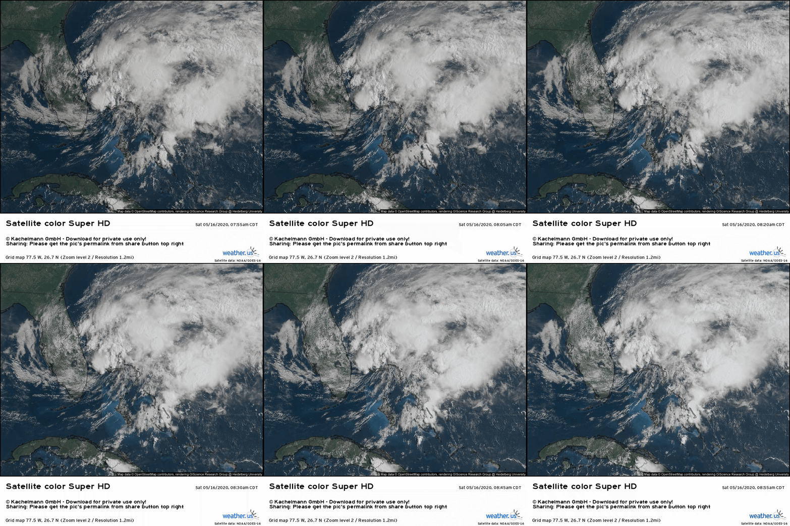
Here’s a look at the system on satellite imagery this morning. As you can probably infer by the swirling of the clouds east of Florida, the center of the system (to the extent that a coherent center exists) is located a little north of the half-way point between Grand Bahama and West Palm Beach. Thunderstorm activity has been able to remain relatively persistent in this area, and as a result this disturbance might actually be able to become fully tropical. Either way, the system is experiencing a bit of westerly/southwesterly shear which will prevent it from really taking off. How do we know some shear is present? Note that the vast majority of the system’s clouds/showers/thunderstorms are located east/northeast of the center, and the cirrus anvils blowing off the top of the convection are drifting northeast. Both observations are clues that the system is dealing with a bit of southwesterly shear.
Regardless of when the entity becomes formally designated by the NHC, or if it’s technically considered tropical or subtropical, expect impacts to Florida to remain relatively minimal today and tomorrow as the shear discussed above keeps the storm lopsided with most of the “heavy weather” east of the center, well offshore.
Tutorial Video: Spaghetti Maps
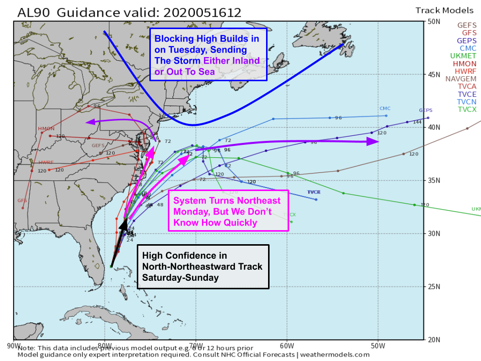
Here’s a look at a slightly different-than-usual spaghetti map showing growing uncertainty regarding the system’s track after the weekend is done. The system will be turning towards the northeast on Monday, but it’s not quite clear exactly how quickly that turn will occur. If the turn happens sooner, the storm will track farther offshore, and impacts to the Outer Banks will be limited. If the turn happens a little later, the storm will track much closer to the coast, and more of eastern North Carolina will experience heavy rain and possibly some gusty winds too. The real question mark comes on Tuesday as a strong high pressure center develops over Maine. This feature will halt the storm’s northward movement, forcing it either west into the Mid Atlantic or east out to sea. At the moment, the out to sea option is by far the most likely, but given decreased forecast confidence due to the pattern (blocking highs are tricky and often subject to lower forecast confidence) and the lack of aircraft observations due to the COIVD-19 situation, I think it’s too early to rule out a left turn.
Many folks in Maryland, Delaware, and New Jersey may hear the words “blocking high” and “left turn” and get flashbacks to Hurricane Sandy which famously hooked left into the coast in response to a blocking high. Remember: the storm we’re watching this week is much weaker than Sandy, and even if it ends up drifting west on Tuesday, the primary impact will be additional heavy rain and some gusts to tropical storm force (40-50 mph) along the coast. The range of possible outcomes with this system spans roughly from “enhanced surf at the beaches” to “heavy rain and steady breezes akin to a moderate-strength nor’easter”. It’s simply too early for powerful hurricanes, especially along the East Coast!
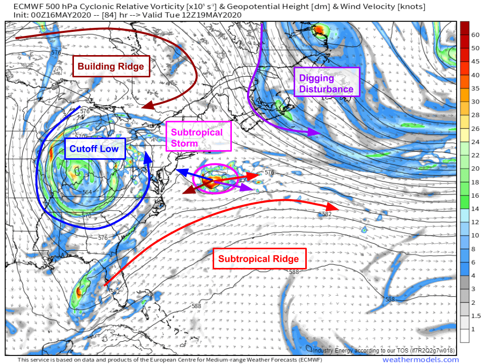
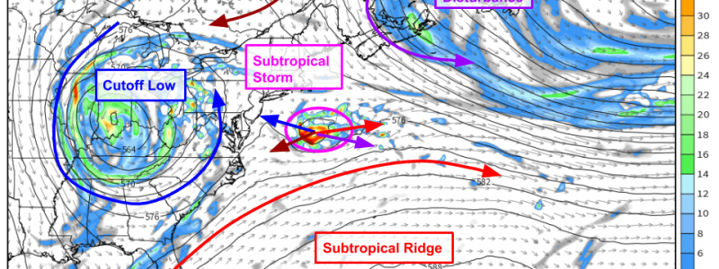
For those interested, here’s a closer look at the steering pattern on Tuesday. If you’re just looking for what to expect and don’t care as much about why, feel free to scroll a bit farther down and skip this section.
By Tuesday, our storm will be caught in a bit of a tug-of-war between four atmospheric features each seeking to steer the system in a different direction. The cutoff low we’ve been talking about over the Ohio Valley wants to pull the system west-northwest, but it’s too far west to exert a strong influence. To the north of the cutoff low, a strong ridge of high pressure (the blocking high discussed above) will try to push the storm west-southwest. If these were the only two features at play, it’d be easy to say the storm will move west into the Mid Atlantic. However, we also have to keep an eye on the subtropical ridge trying to push the system east-northeast, and an upper-level trough over Nova Scotia trying to push the system east-southeast. Add these steering influences together, and you come up with ~0 net steering. Thus if any of these features ends up being stronger (or weaker) than expected, the balance of steering patterns may shift and the storm may take a very different path.
You may recognize this tug-of-war as the same challenge we faced when trying to predict Hurricane Dorian last year, though of course the stakes were much higher when it was a Category 5 hurricane being batted around by various synoptic features instead of a mid-grade (sub)tropical storm.
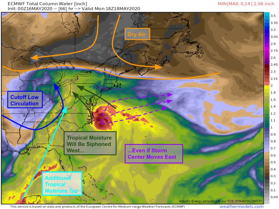
Interestingly, the track of whatever entity emerges from this tropical disturbance is unlikely to matter a whole lot at the end of the day as far as onshore impacts go. The exception would be along eastern NC/SE VA and the Delmarva Peninsula. Because this is a weak system from a winds perspective, the focus is really going to be on the system’s heavy rains and the associated flooding threat. Even if the storm moves east, southeasterly winds through the mid-levels of the atmosphere will bring moisture associated with the storm into the Mid Atlantic, where it will be rained out by forcing associated with the upper-level cutoff low. Thus there will be a significant flooding threat in the Mid Atlantic regardless of the cyclone’s exact track. The flooding will be worse if the core of the storm does move onshore, but that shouldn’t lead us to dismiss the hazard just associated with the upper-level low if the cyclone center moves into the Atlantic on Tuesday.
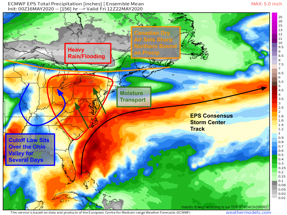
How much rain are we talking? Here’s a look at the EPS mean total precipitation forecast through what most guidance agrees is the end of the event (on Friday). Keep in mind that these ensemble members run at too low a resolution to “see” thunderstorms, so this is just a “blanket estimate” rather than a precision forecast. Either way, hopefully you get the idea that a wide swath of the Mid Atlantic as well as portions of New York, Michigan, and Ohio are all in for at least 2-4″ of rain from this event. There will certainly be localized totals much higher than that where convective cells happen to train for especially long, or where orographic lifting helps enhance heavy rain bands. It should be noted that EPS guidance is nearly unanimous in carrying the subtropical storm center out to sea, so even this represents the “better case scenario” of more limited/indirect involvement with the deepest moisture associated with the cyclone’s core.
So what’s the takeaway from all this? We know a subtropical or tropical storm is likely to form today or tomorrow as the disturbance east of Florida continues to organize. We know this system will move NNE towards the Outer Banks of North Carolina by Monday, at which point it may either turn west into the Mid Atlantic or east towards the open ocean. Regardless of the cyclone center’s exact track, a prolonged period of heavy rain is likely across the Mid Atlantic as moisture associated with the cyclone is funneled northwest by an upper-level low over the Ohio Valley.
I’ll have more updates both here and on twitter (@WeatherdotUS and @JackSillin) in the coming days as we know more about the storm’s track.
-Jack
