Strong To Severe Storms Expected In Parts Of The Southern Mississippi Valley Today
Hello everyone!
A strong upper level low pressure system is moving east this morning through Iowa, with a surface low pressure system located beneath it. A cold front extending south from that low will touch off thunderstorms this evening from Northern Louisiana all the way up to Chicago. The greatest risk for severe storms will be near and just north of Memphis, Tennessee.
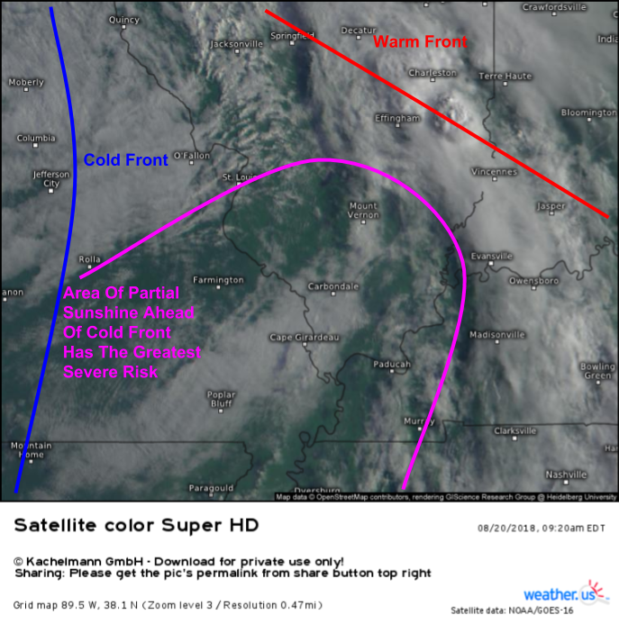
Visible satellite imagery from GOES-East highlights a couple of the features that will be important to this afternoon’s storms. A warm front is lifting northward through Indiana and Illinois, with some shower/thunderstorm activity already ongoing along it. A cold front is located farther west in Missouri, with parts of the warm sector (the area behind the warm front and ahead of the cold front, where the warm air is located) seeing partial sunshine. It’s these sunny warm sector areas that have the greatest chance to see severe storms this evening.
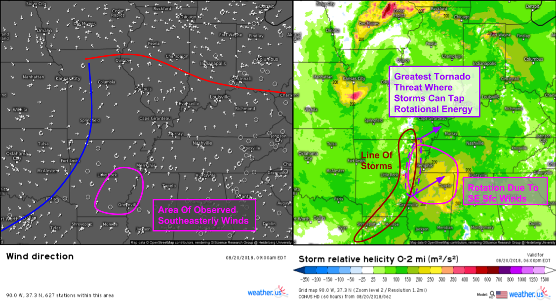
Wind direction observations this morning show an area of southeasterly winds in the Memphis-Little Rock corridor, part of the warm sector area discussed above. Winds almost always blow from the west aloft, and rotation in the atmosphere comes from wind speed/direction changing with height. It then makes sense that as your surface winds become more easterly, there will be more rotation in the atmosphere. As a result, the southeasterly winds near Memphis/Little Rock mark a local maximum of rotational energy. Forecast model data for this evening shows this rotation maxima moving northeast, becoming centered over Memphis as opposed to Southeastern Arkansas. As storms develop along the cold front, they will tap into this rotational energy, posing a tornado threat in this area. Farther north and farther south, damaging winds will be the main threat with little in the way of rotational energy present due to southwesterly surface winds (almost the same as WSW winds aloft).
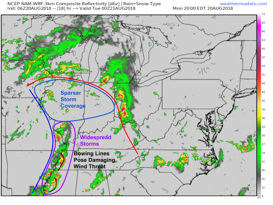
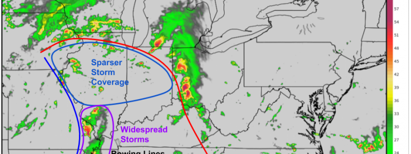
Simulated radar imagery from the NAM model via weathermodels.com highlights some of the features we’ve been discussing, despite the fact that it’s not meant to precisely portray storm structure/placement. Areas in the warm sector that aren’t seeing sunshine this morning in northern IL/IN will see storms develop, but they will be much weaker and not as widespread as storms farther south. Those storms to the south will likely develop as supercells in Arkansas early in the evening, before consolidating into line segments as they move northeast. In addition to the tornado threat discussed above, the lines of storms will also pose a damaging wind threat. Storms will weaken overnight as they move into the Ohio Valley.
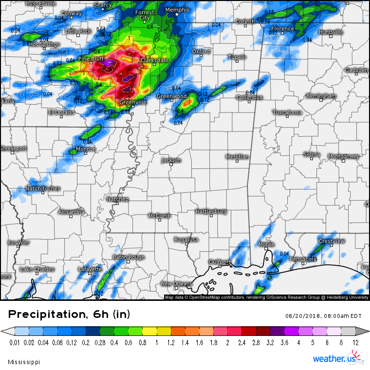
In addition to the severe weather, we’ll also be watching for flash flood potential today, especially in areas that are already seeing flash flooding this morning. This map shows 6 hourly rainfall totals ending at 7 AM CDT. Note the area of >2″ rains northwest of the Greenville-Clarksdale MS corridor. Flash flooding is already ongoing in this area as of 9 AM CDT, and any storms that move over this area this afternoon/evening will likely produce more flooding. Flooding is also possible farther north with any storms that happen to “train” over the same locations repeatedly. Deep tropical moisture is present across the whole area, so storms will be producing very heavy rains.
Track the storms at weather.us with HD radar, GOES-East satellite imagery, and lightning analysis (get latest data via refresh button at the top left of the map). Click any map to zoom in for a closer look, and navigate between storm tracking tools via the blue buttons at the top of the map.
-Jack
