Strong Spring Storm Expected to Bring a Multi-Day Severe Weather Outbreak to the South on Easter Weekend
Hello everyone!
A strong spring storm will develop in the Plains this weekend as the upper level low currently spinning over California moves east ahead of a strong trough digging into the Rockies. While some snow is expected on the northern side of this storm in the northern Rockies/northern Plains, by far the biggest threat from this system will be the severe weather south of the storm’s track. This blog will take a general look at why this severe weather event could end up being a higher-end threat for parts of the Deep South from Texas to North Carolina. More detailed/specific analysis will be posted here in the coming days.
The upper level low responsible for the upcoming storm shows up clearly on GOES-East WV imagery this afternoon. The system is currently “cut off” from the polar jet (notice the polar jet disturbance diving southeast through Montana near the upper right of the map) meaning there’s no way for it to move east. Watching the loop above should convince you that indeed the system is nearly stationary (perhaps drifting slightly south) at the time of this writing. We’ll have to wait for another polar jet disturbance to dig south through the Rockies on Saturday before this low can begin sliding east.
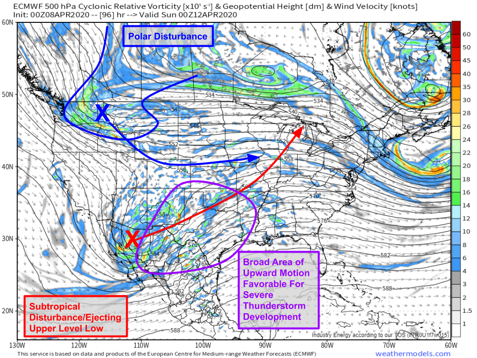
500mb vorticity forecasts from the ECMWF highlight the aforementioned polar disturbance digging into Idaho on Saturday evening. As that disturbance moves south, westerly flow on its southern flank will push the upper level low into northern Mexico. Upward motion will then increase over Texas in response to upper level divergence and height falls associated with the approaching disturbance. This will set the stage for thunderstorm development along the dryline on Saturday afternoon.
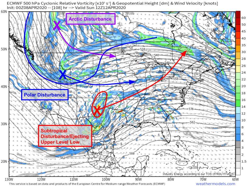
By Sunday morning, the disturbance most directly responsible for the severe weather outbreak will be moving through the Texas Panhandle on Sunday morning while two additional disturbances dig southeast through the Northern Rockies. Thankfully, it looks like the polar/arctic disturbances will remain spatially separated from the southern disturbance. If those disturbances were to merge (“phase”), a much more intense storm would’ve been expected.
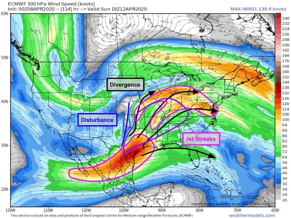
By Sunday afternoon, pair of upper level jet streaks will be lining up in the Plains ahead of the disturbance discussed above (over Texas). These jet streaks will be “coupled” meaning that the upper level divergence associated with the left exit region of the southern jet will be co-located with the upper level divergence associated with the right entrance region of the northern jet. This will support strong upward motion across much of eastern Texas as well as a wide swath of the Mid Mississippi Valley.
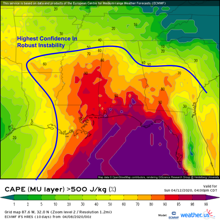
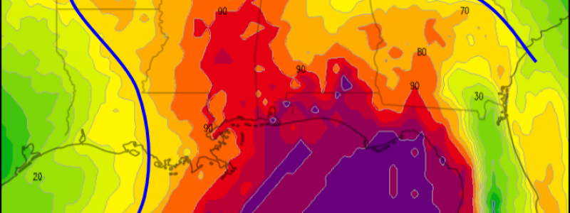
As the disturbance moves into the Plains, a surface low will develop in northern Texas/western Oklahoma. Southerly winds ahead of that low will help pull rich Gulf of Mexico moisture north on Sunday. That moisture will support robust instability needed for severe thunderstorm formation. While some uncertainty remains regarding the extent to which the atmosphere will be able to destabilize, EPS guidance shown above indicates that CAPE values supportive of severe storms (>500 J/kg) are quite likely across Mississippi, Alabama, and adjacent parts of FL/GA/LA/AR. The nuances of the instability forecast will be watched closely over the coming days.
Aloft, strong winds associated with the jet streaks discussed earlier will produce very strong wind shear. Deep layer shear values in excess of 80kts will support intense severe storms (either supercells or a squall line depending on the nuances of the setup). Additionally, low-level shear values over 50kts will support a strong tornado threat if storms are able to stay discrete and sufficient instability is able to develop. We’ll keep an eye on forecasts over the coming days and post updates here as the situation becomes clearer.
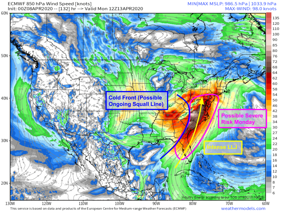
By Monday, the storm will begin to decay over the Great Lakes. However, any squall line that forms on Sunday will likely still be ongoing Monday morning as the system’s cold front sweeps towards the East Coast. Ahead of that front, a strong southerly low level jet (LLJ) will continue to supply storms with abundant moisture, instability, and wind shear. As a result, expect the threat of severe storms to continue into Monday along the East Coast roughly from PA/NJ down to FL. It should be noted that there’s still a bit of uncertainty regarding the exact timing of this storm especially once we get to Monday. It’s possible that the cold front sweeps offshore relatively early Monday morning which would limit Monday’s severe threat. That said, a faster system would still bring severe weather to the Mid Atlantic/Southeast but it would just be overnight Sunday instead of Monday afternoon.
Overall, this system appears to have the makings of a potent severe weather event for much of the Deep South. While there are still many unanswered questions, residents between Texas and Florida should be ready for severe storms this weekend. Make sure to dust off your severe weather plans before storms arrive in your neighborhood, and double check that you can still execute those plans given the ongoing COVID-19 situation.
I’ll have more updates here and on twitter (@WeatherdotUS and @JackSillin) as we get closer to this event.
-Jack

