Strong Cold Front Will Bring Snow To Parts Of The Plains This Week
Hello everyone!
A strong cold front will be making its way through the Plains this week as high pressure moves south from Canada. This front will bring a rapid drop in temps, strong winds, and some heavy snow for parts of the Plains as it moves south. This post will outline what to expect from this system, and how its forecast can be visualized using our tools at weather.us and weathermodels.com.
The front is already making southward progress this morning and just crossed over the border into the US as of 3 AM MDT. Wind direction observations are probably the best way to track the front’s progress, though the fall in temps behind the boundary is substantial enough that you could also use station temperatures to follow its progress. The cold air will continue to surge down the eastern side of the Rockies in the coming days.
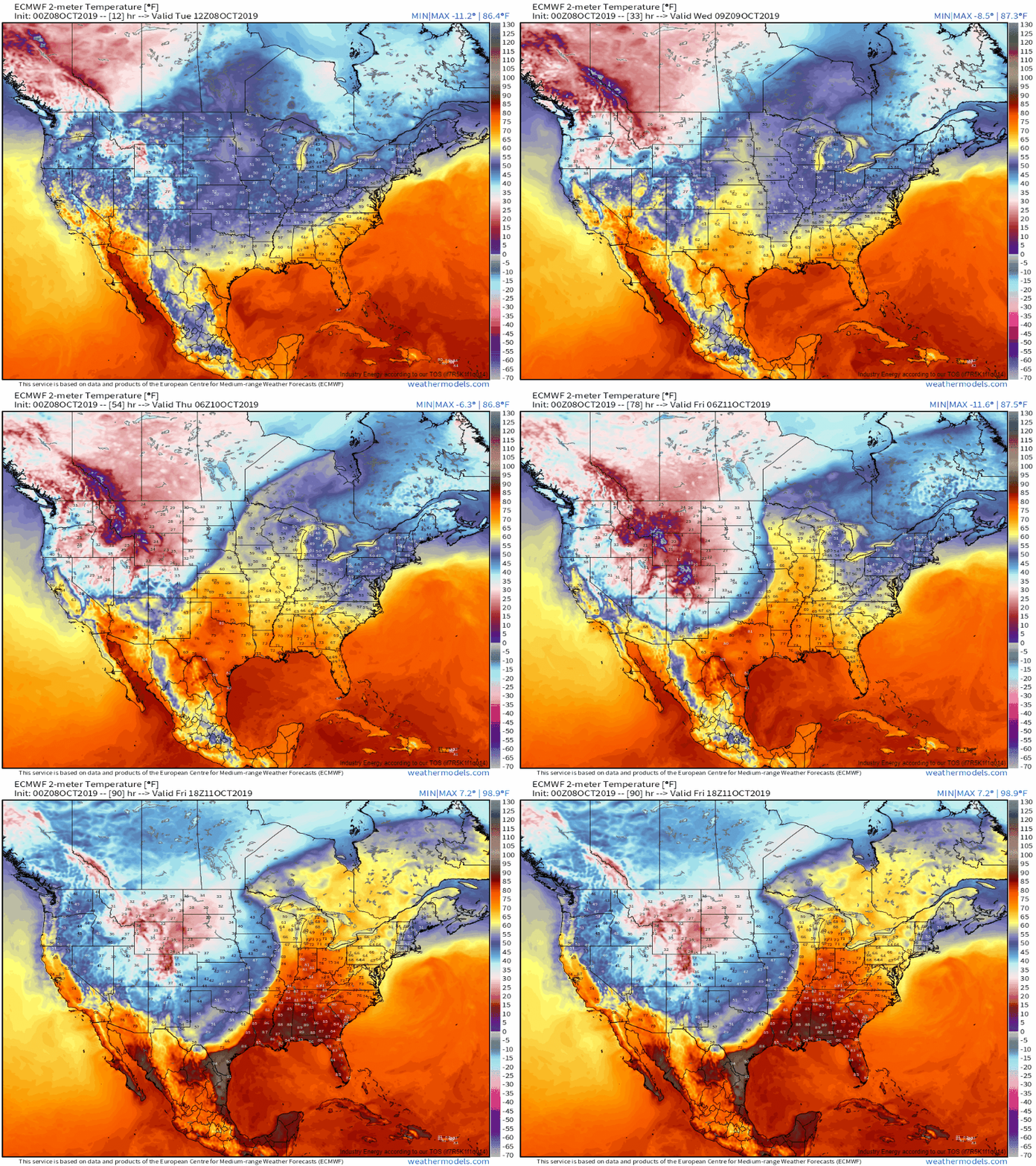
This loop from the ECMWF’s three-hourly dataset does a great job showing how cold air will spill southeast over the next few days. The closer you are to the Rockies, the sooner you’ll see the cold air. Meanwhile to the east of the front, warm air will be surging north with temps rising well above what we’d expect for this time of year. If you look closely enough, you’ll see some small waves along the front (areas where the front bends a little bit) that eventually consolidate into one bigger wave over Minnesota. This indicates that an area of low pressure will form along the front and will gradually intensify as it moves NE from Kansas to Minnesota. This system will help push the cold air farther east, and will bring heavy snow/strong winds to parts of the Northern Plains this weekend. GIF via weathermodels.com.
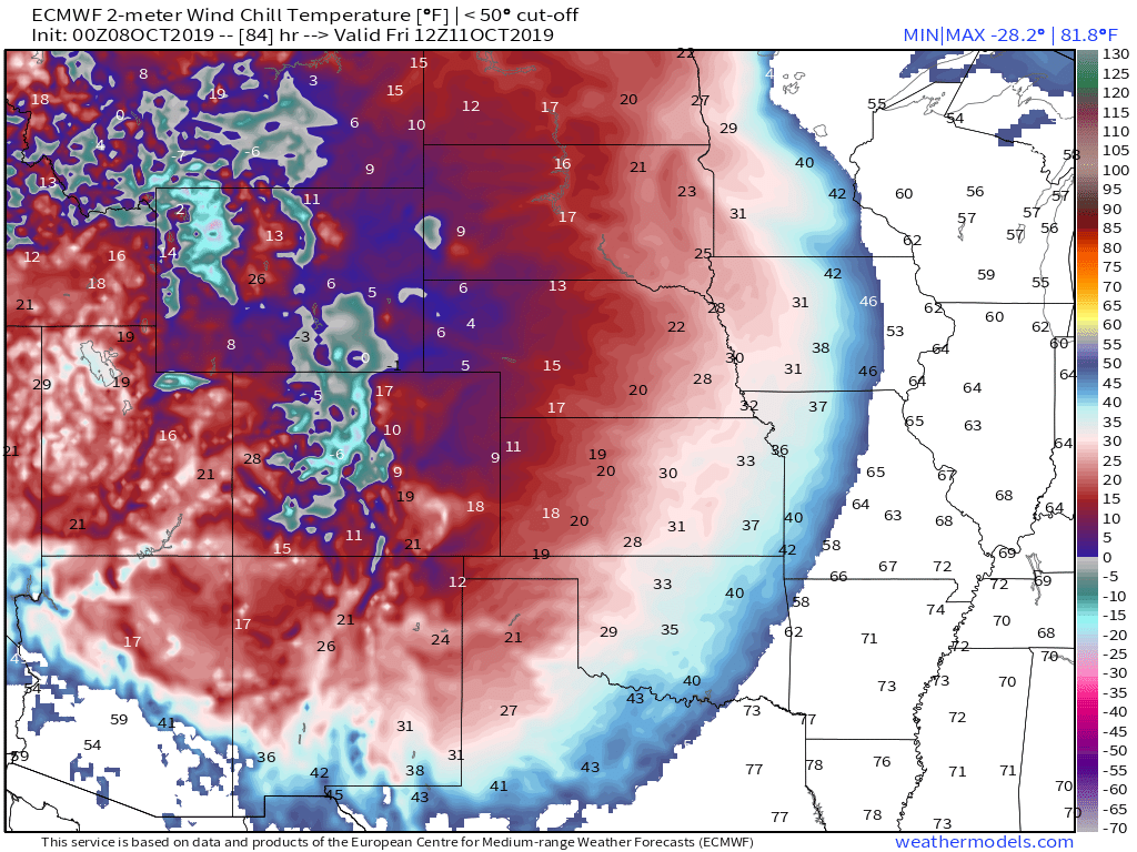
The airmass behind the front won’t quite be as cold as those that move out of the Arctic during the midwinter months, but it will be very cold for October. The above map shows projected wind chill values on Friday morning. Wind chills are likely to dip into the 10’s as far south as the Texas Panhandle! Map via weathermodels.com.
The temperature drop will also happen quickly, especially the closer you are to the Rockies. Denver will likely top out around 80 degrees on Wednesday before the cold front arrives during the evening. By Thursday morning, the city will fall below freezing and will stay there for the rest of the day. Temperature falls over 20 degrees per hour are quite likely with this front, so be prepared for rapidly changing conditions if you’re headed out and about! Chart via weathermodels.com.
Pacific moisture forced to rise up and over the front’s low level cold air will condense into precipitation along and behind the boundary. As the cold air continues to surge south, much of that precip will end up falling as snow especially from Wyoming through the Dakotas. The wave of low pressure I mentioned earlier is visible on the above precip type/sea level pressure map over Kansas. As that low intensifies and moves northeast, rain will change to snow across eastern parts of South Dakota and western parts of Minnesota during Friday and Saturday. Map via weathermodels.com.
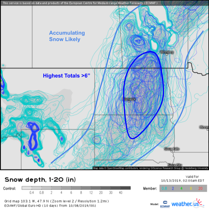
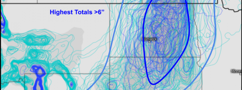
Snow will be falling heavily on Friday and Saturday as that storm ramps up with the highest snow totals expected over parts of central North Dakota and northern South Dakota. While it remains unclear exactly how much snow will fall here, over 6″ is fairly likely across the aforementioned favored areas. Snow will also fall farther southwest across SW SD, SE WY, and NW NE, but the low won’t be quite as strong when it’s passing by these areas and thus there won’t be as much dynamical support for heavy banded snow. As a result, lower totals are expected in these areas.
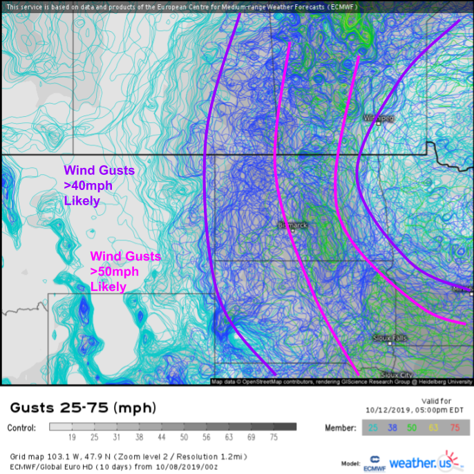
In addition to the heavy snow, this storm will also bring some very gusty winds to parts of the Northern Plains, as shown by the EPS spaghetti map above. Each of the dark blue contours represents one ensemble member’s forecast outlining the area expected to see wind gusts above 38 mph, while each green contour traces out one ensemble member’s forecast for wind gusts above 50 mph. I’ve outlined in purple and pink the approximate corridors with the greatest likelihood to exceed each wind threshold. Spaghetti maps like this were just added to weather.us yesterday for several different parameters, be sure to check them out!
While final snow totals may not be overly impressive by midwinter standards, 6″ of snow driven by 50 mph wind gusts is extremely impressive for mid October! This storm will end the growing season for any parts of this area that haven’t gotten their first hard freeze yet, and will be very dangerous for livestock that don’t have access to sheltered areas.
The storm will weaken as it moves east on Sunday.
-Jack

