Strong Coastal Storm To Bring Coastal Flooding And Gusty Winds To The Carolinas This Weekend
Hello everyone!
A strong coastal storm is expected to develop off the Southeast coast this weekend, and it will bring some fairly serious impacts to the Carolinas as it slowly moves NE. The biggest threat will be coastal flooding and erosion due to persistent onshore flow. That onshore flow will create a 2-4 foot storm surge and large waves, both of which will cause problems for coastal infrastructure, especially along the Outer Banks of NC. This post will outline the general forecast for this system. If you’re looking for town-specific forecast info, please head over to weather.us and type your town’s name into the search box to get the forecast most relevant to you.
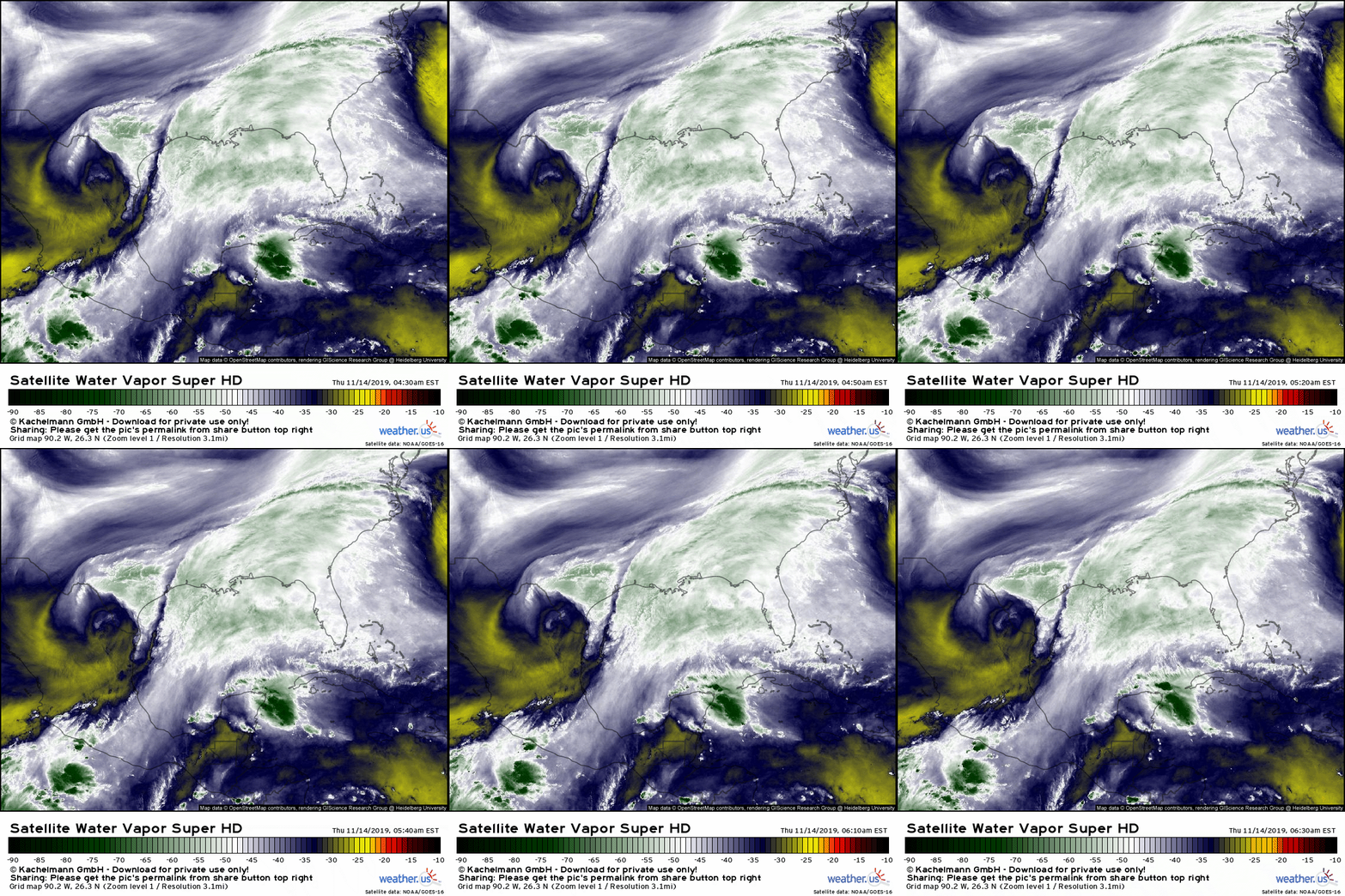
GOES-East WV satellite imagery does a good job highlighting the upper level disturbance that will drive the storm’s development over the next few days. As the upper level low currently moving through the lower Rio Grande valley crosses the Gulf of Mexico, an area of low pressure will develop at the surface. This low will gradually intensify as it moves ENE towards the waters of the SW Atlantic, where it will reach its peak intensity Sunday. The WV loop above also highlights the deep tropical moisture this system will have access to, both from the Eastern Pacific and the Caribbean.
While the developing storm will have the support of a strong upper level disturbance and deep tropical moisture, its intensity will be mitigated by its position relative to the prevailing jet stream.
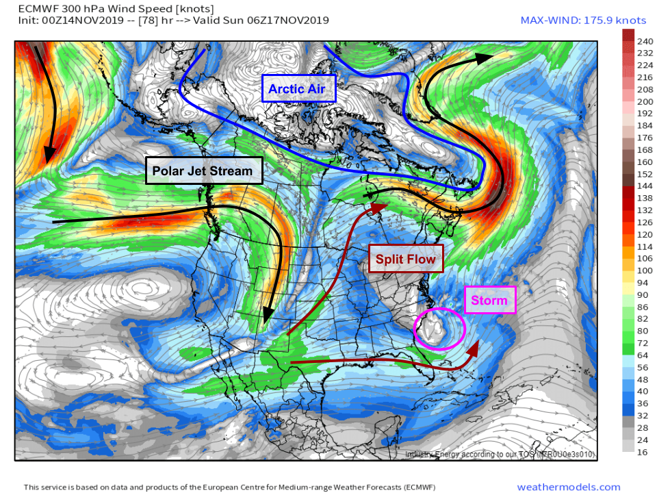
Here’s the ECMWF’s jet stream (300mb wind) forecast for Saturday night. Note that the Polar Jet and its embedded jet streaks (localized pockets of very intense winds) remain well north of the developing storm. In fact, the storm will be caught in the lull between two branches of the jet stream which will diverge over the Plains to form what’s known as a “split flow” pattern. In this configuration, half of the jet goes north and half goes south, but neither branch is very strong. The key takeaway is that once the storm gets near North Carolina, it will lack strong jet stream support, which means it will be moving slowly, and its structure will be different than that of a typical wintertime nor’easter. Map via weathermodels.com.
The lack of jet involvement means the temperature gradient across the system will be minimal. Note that there’s no Arctic air within 1,000 miles of the storm’s center. While there is some temperature gradient between the warm air off to the storm’s east and the cooler air to the west, there’s no intense clashing of airmasses near the storm’s center to drive rapid intensification in the way we’d expect from a wintertime nor’easter. Map via weathermodels.com.
The consequence of this will be a broad and somewhat disorganized center of circulation, as shown by the ECMWF’s 10m wind forecast for Sunday morning. Note that there’s no well-defined center, just a broad area of rotating winds with a few smaller embedded mesoscale circulations. Without the involvement of a strong polar jet streak, we won’t get intense thermal gradients near the storm’s center, which will lead to the broad and disorganized storm structure. What does that mean for the Carolina coast? Instead of a brief hit of very intense winds, you can expect slightly lower windspeeds, but over a longer duration. While this means that the threat for power outages/tree damage might be lower, the threat for coastal impacts including storm surge and large waves will be much higher.
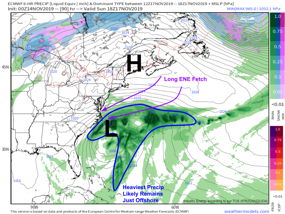
A zoomed out forecast of precip and sea level pressure from the ECMWF model highlights the long ENE fetch that will set up on the north side of the storm on Sunday. While a small area of 60 or 70 mph winds in a more intense storm might seem more intimidating, from a coastal impact perspective, it’s these events that pack a much harder punch. 40mph winds passing over 500 miles of open water will generate much larger surge/waves than 70mph winds passing over a much shorter distance. This event will bring serious coastal flooding to the Outer Banks, parts of which are still very much in recovery mode after Dorian. Map via weathermodels.com.
Also note the strong area of high pressure moving through Maine in the map above. This high will help drive that long ENE fetch, but it will also prevent much in the way of impacts north of the Chesapeake Bay region. While coastal New England could get a glancing blow from the storm as it moves out to sea early next week, at the moment it looks like the worst impacts from this system will be along the Outer Banks of NC.
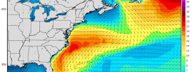
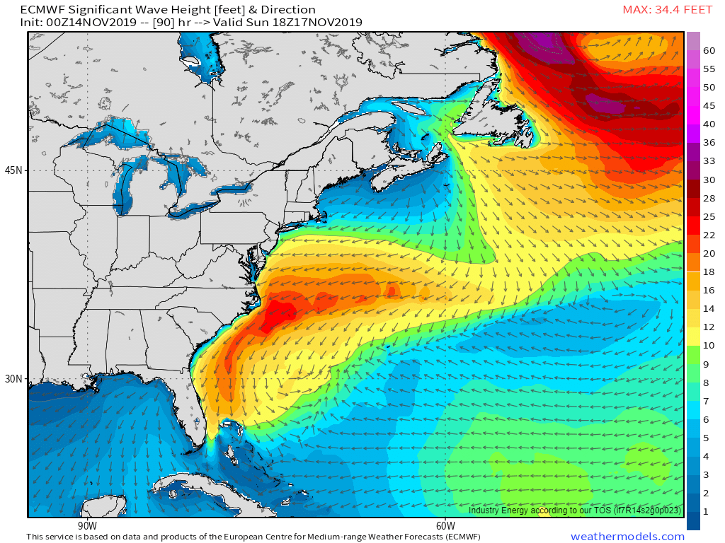
ECMWF significant wave height forecasts show 20-30 foot seas off the Outer Banks by Sunday afternoon. While that doesn’t mean that you’ll see 20-30 foot waves breaking on the beach, there will be very heavy surf and associated coastal erosion. The NWS office in Morehead City NC warned this morning that parts of NC 12 (the main road on the Outer Banks) could become inundated and impassable at times due to the combination of storm surge and wave activity. The strong NE winds will also promote sound-side flooding, especially south of Oregon Inlet for those familiar with the area. Map via weathermodels.com.
The storm will slowly move ENE on Monday, with impacts gradually lessening early next week. That being said, another coastal storm could develop during the middle of next week, possibly bringing another round of heavy rain, strong winds, and coastal impacts to NC. That second system stands a better chance of bringing impacts farther up the East Coast, though details regarding timing, intensity, and type of any precipitation remain uncertain.
-Jack




Dude, awesome job giving we the peeps the details for the weekend weather!!!! Ready
to duck and cover should this storm move into the Chesapeake region.
Thanks for posting!