Stormy On Both Coasts Today
Hello everyone!
Today will feature an active day of weather along portions of both the east and west coasts. In the Northeast, yet another powerful Nor’easter is rumbling by offshore, with heavy snow and high winds already impacting portions of the area. Over two feet of snow could fall in some places, with wind gusts over 50 mph. Out west, a Pacific storm is making landfall today with several inches of valley rain and heavy mountain snow expected to be measured in feet.
Overview
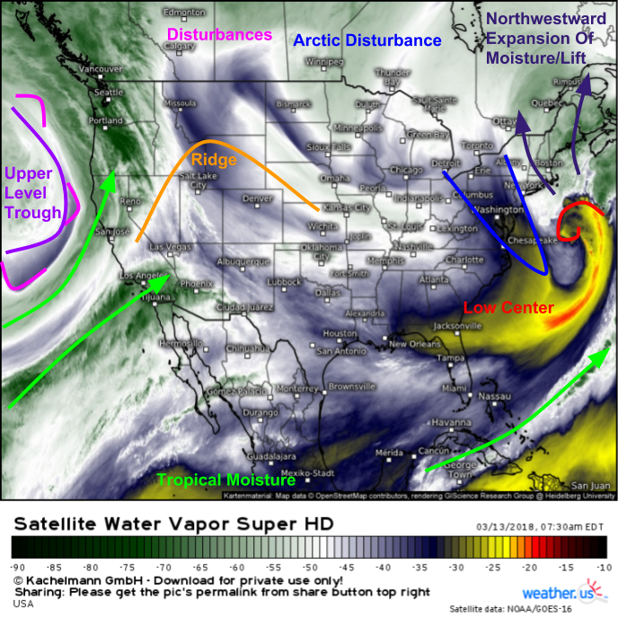
Here’s a look at GOES-East water vapor satellite imagery showing elements involved in both storm systems, as well as quiet weather under ridging in the center of the country. On the East Coast, a strong storm is seen southeast of Cape Cod. The storm itself is wrapping around itself as it continues to develop. A disturbance that originated in Northwest Canada is digging underneath the storm, and is helping to bring some of the storm’s moisture back to the northwest. This means that even as the storm itself cruises east towards the Canadian Maritimes, heavy snow will spread all the way back to western parts of New England. The storm also has a deep feed of tropical moisture stretching down to Cancun, which will produce an additional boost to snow totals. Out west, two pipelines of tropical moisture are noted streaming into California out ahead of an upper level trough located offshore. Disturbances are pinwheeling around this trough, and each will help focus precipitation even for areas not benefiting from terrain induced lifting.
New England Blizzard
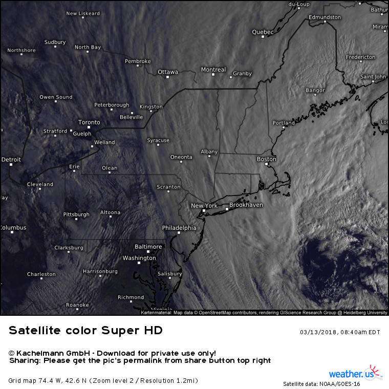
Here’s another view of the Northeastern storm from GOES-East via the visible satellite band. The storm is already well developed this morning, with an eye-like feature noted over the storm’s center southeast of Cape Cod. Satellite loops clearly show the northwestward stream of deep moisture that’s responsible for the heavy snow, as well as the swirling motion of the low itself, and the bubbling of thunderstorm activity offshore. Also visible are mountain gravity wave clouds over the Mid Atlantic as cold air pours southward on gusty NW winds.
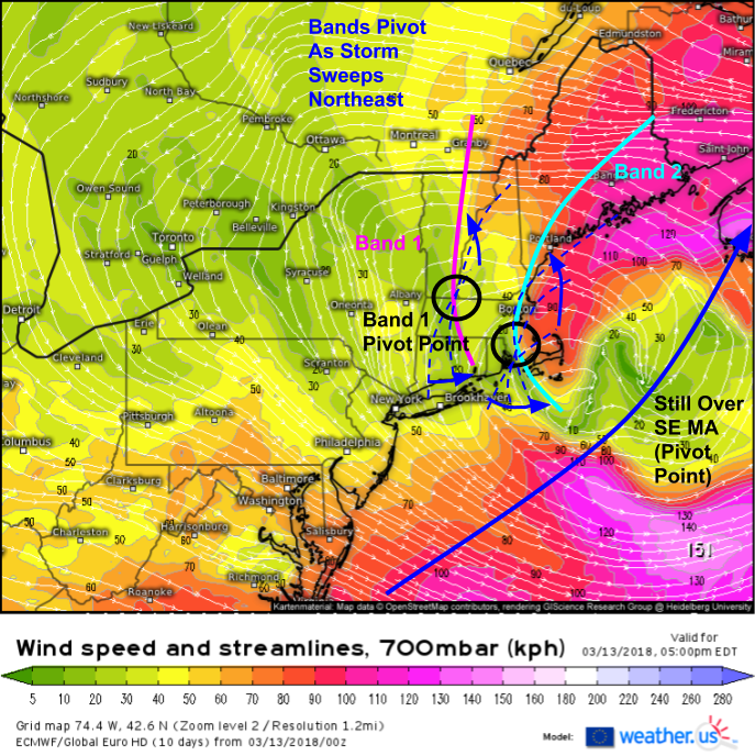
Looking behind the scenes a little bit, we can see heavy bands of snow lining up exactly where we would expect them given the setup. The model map shows winds at 700mb, or around 10,000 feet. When winds rapidly decelerate and shift direction at this level in a storm setup like this, it means that two airmasses are crashing together, resulting in a process known as frontogenesis (creation of a front). Frontogenesis results in heavy banded precipitation when enough moisture is available, as is the case now. Two areas of frontogenesis are evident on the model projection, one extending through western parts of CT and MA, and another moving onshore in RI and SE MA. HD radar imagery for the same time (8 AM EDT) shows bands of heavy snow located in those exact areas, an indication that the abstract-seeming processes aloft we see on model forecasts actually do result in tangible impacts to sensible weather at the surface.
We can apply the frontogenesis concept to forecasting as well, by looking at the 700mb wind out through time. We can see that by this evening, we’ll be contending with the same two bands, one over Western New England, and one over Eastern New England. These bands will pivot as the low swings northeast. The bands will pivot around a point, and near the point, heavy snow will fall for a much longer duration compared to where bands are mobile. Forecasts show SE MA and the MA/VT/NH border region to be favored locations for pivot points today. As the storm moves northeast then curls north into Nova Scotia tonight, those pivot points will redevelop somewhere in NH/ME.
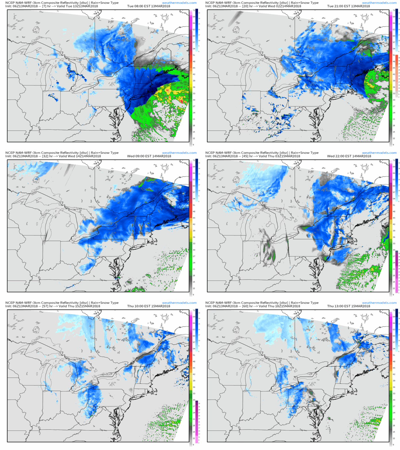
Here’s a simulated radar animation showing how the storm evolves over the next couple days. Notice that snow will continue in parts of Northern New England all the way through Thursday as the upper level trough hangs around the area, stopped from progressing east by blocking high pressure. GIF via weathermodels.com.
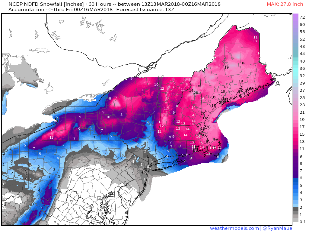
Here’s the NWS forecast for snow totals through Thursday evening when the storm will be all but done. The highest totals will be found in from Boston north into Maine and the mountains of New Hampshire. A general 18-24″ is expected in that area, with totals locally exceeding two feet in some of the mountain locations that will see upslope enhancements. Map via weathermodels.com.
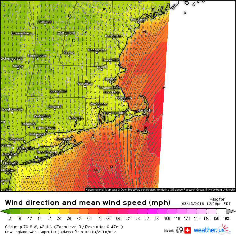
In addition to the heavy snow, high winds will also be a concern as the storm continues to intensify today. Winds along the shorelines of MA, NH, and ME will gust over 50mph at times from the NNE. Gusts over 30 mph are expected inland. These winds will whip the snow into a frenzy, resulting in plenty of blowing and drifting snow that will sharply reduce visibility. Blizzard warnings have been posted for this area as there is a high probability of visibilities dropping below a quarter mile for more than three hours due to heavy snow and winds above 35 mph. Even outside of these areas, winds will be gusty enough for locally reduced visibility, but not strong enough to meet the official blizzard criteria (stated above). Gusty winds will also enhance the power outage threat, especially in SE MA where snow will be heavier and wetter due to warmer temps.
Sierra Special
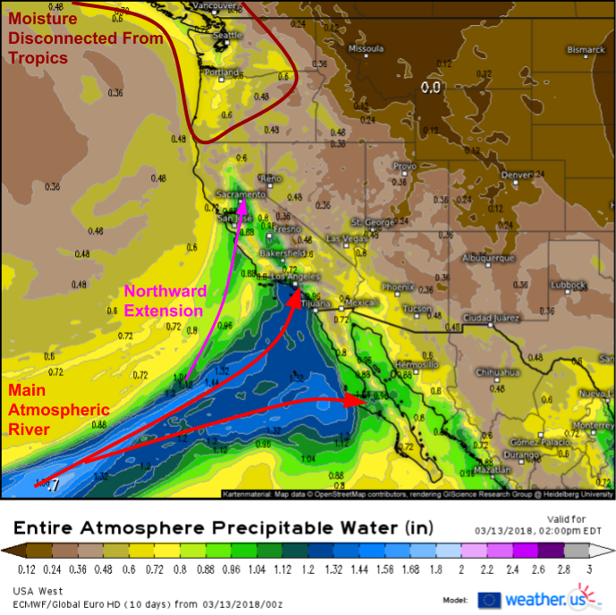
Heavy snow will also be falling out west in the higher elevations of the Sierras as a deep plume of tropical moisture is driven northeast from the Pacific, as shown on this ECMWF precipitable water (moisture) map. The main “Atmospheric River” will be aimed to the south, towards Baja California, but a northward extension will support heavy lowland rain and mountain snow up into the Northern Sierras. Farther north, moisture will linger from previous storms up in the Pacific Northwest, but because that area will be cut off from the deepest tropical moisture, rain and snow are not expected to be nearly as heavy.
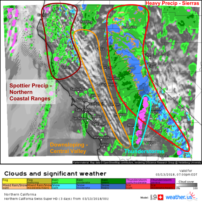
Here’s the Swiss Super HD model’s forecast for this evening, showing several features of note associated with the storm system. First, we can see the area of steady, heavy precipitation over the Sierras. This is where the highest rain/snow totals will be found. Second, with southwest winds, downsloping off the coastal ranges will result in partly cloudy skies and little/no precipitation across parts of the Central Valley. Spottier precipitation will be found closer to the upper level low itself, in the coastal mountains north of San Francisco. There could even be some thunderstorm activity southeast of San Francisco. These storms could produce some gusty winds and small hail, but should largely remain below severe limits.
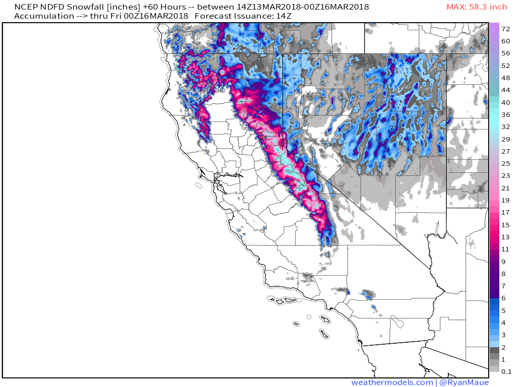
Here’s the NWS’s snow forecast for what’s left to fall (rain and snow is already ongoing, as seen on HD radar imagery) through Thursday evening. The highest summits of the Sierras will pick up an additional 4-5 feet of snow on top of what’s already fallen. The lower slopes of the Sierras will see hefty rainfall totals as well, with totals of several inches expected. Map via weathermodels.com.
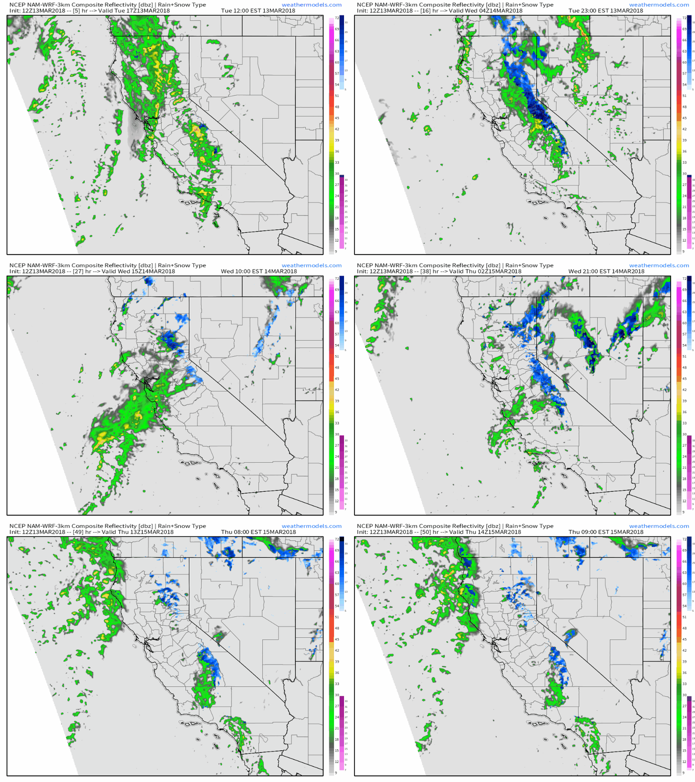
Here’s a simulated radar loop showing the evolution of rain and snow through Thursday, before the next storm begins to approach from the west. Notice the steadiest and heaviest precipitation consistently focused around the Sierras, with more intermittent bursts of activity elsewhere. GIF via weathermodels.com.
For more information on what to expect in your town from either one of these storms (or for anywhere, storm or no storm) check out all the tools we have on weather.us including Forecast Essentials (basic info, tutorial) and Forecast Ensemble (multi-model comparisons, tutorial).
For more information on the local forecast for ME/NH, check out my local blog post: https://forecasterjack.com/2018/03/13/major-winter-storm-today/
-Jack
