Sprawling Storm System To Bring Active Weather To Most Of The Country Today
Hello everyone!
The strong storm we talked about hitting California this weekend is now moving east, and it will bring the full array of impacts from heavy snow to ice to severe storms, strong winds, and flooding. I’ll try to take at least a quick glance at each of these elements here, with links to additional resources you can use to get more info for the part of the storm most relevant or interesting to you.
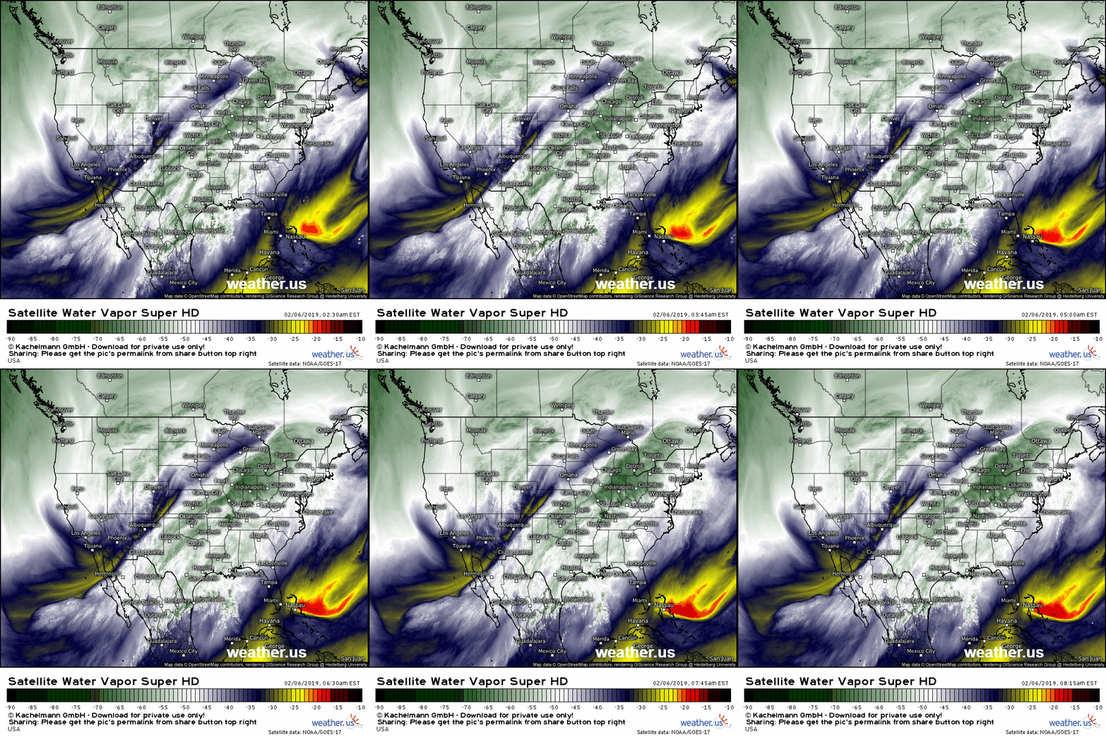
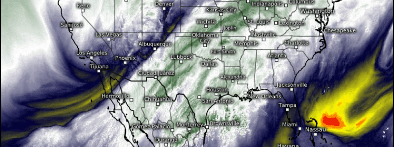
GOES-East WV satellite imagery highlights a few key components to this system. First and foremost, note the deep plume of tropical moisture streaming north from the Eastern Pacific. That moisture is available to be tapped by various disturbances ranging from Colorado to Michigan, and we’ll see plenty of heavy precipitation as a result. The main storm system is clearly visible just west of Denver, with a secondary disturbance a little bit harder to pick out north of Green Bay. Both systems will play a part in today’s active weather. Because it’s stronger, I’ll start with the western disturbance and its impacts.
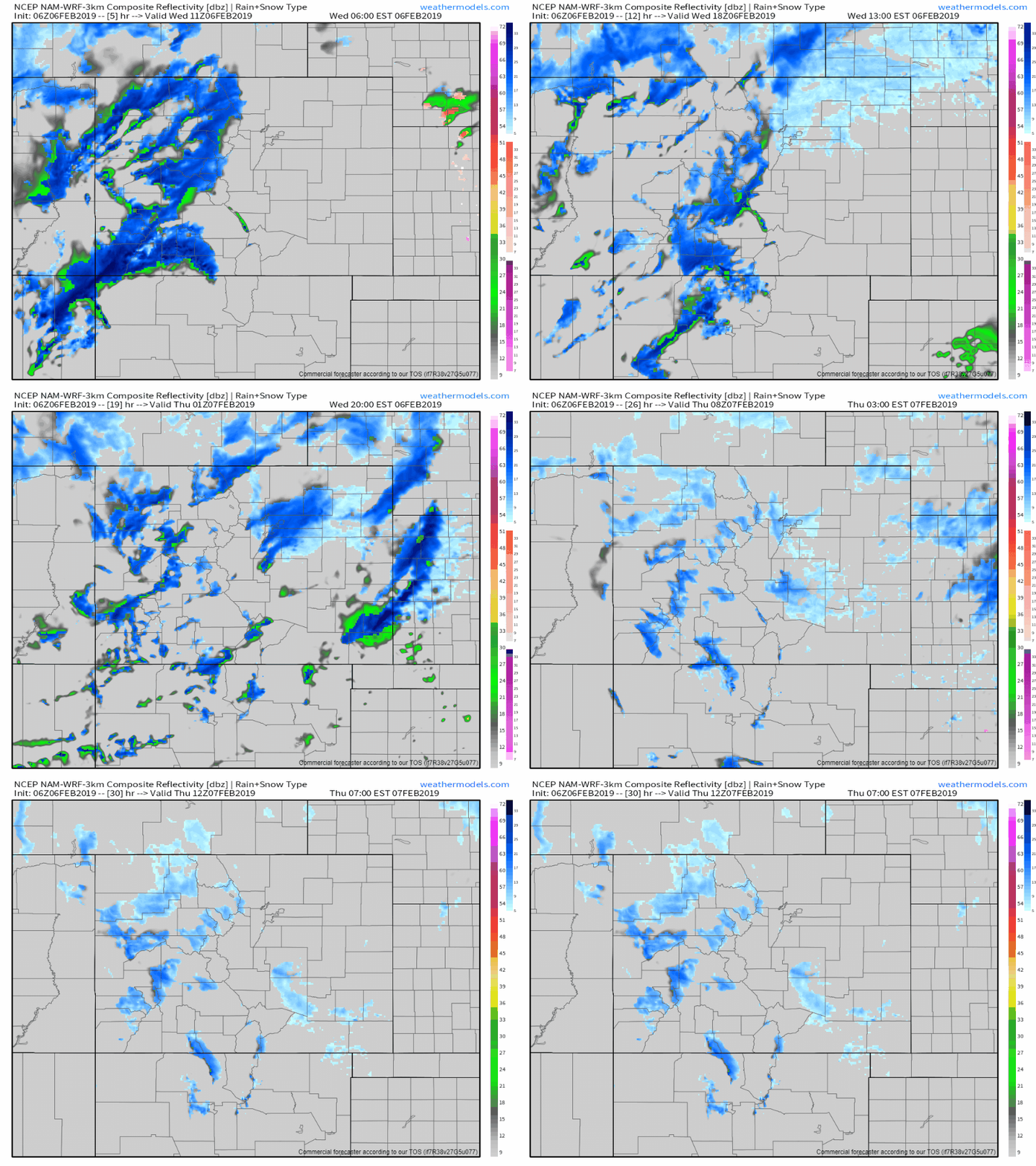
The first impact from this system will be heavy snow in the Rockies. This simulated radar loop shows heavy snow bands moving through the mountains this morning, before emerging onto the Plains this afternoon/evening. The mountains will see the heaviest accumulations while lower elevations will only manage a couple inches. However, those couple inches could fall in a very short time making travel extremely difficult. Snow winds down outside of the mountains later tonight as the storm moves east.
More info: NWS snow forecasts, Denver HD radar, Denver weather overview (available for any town via search box)
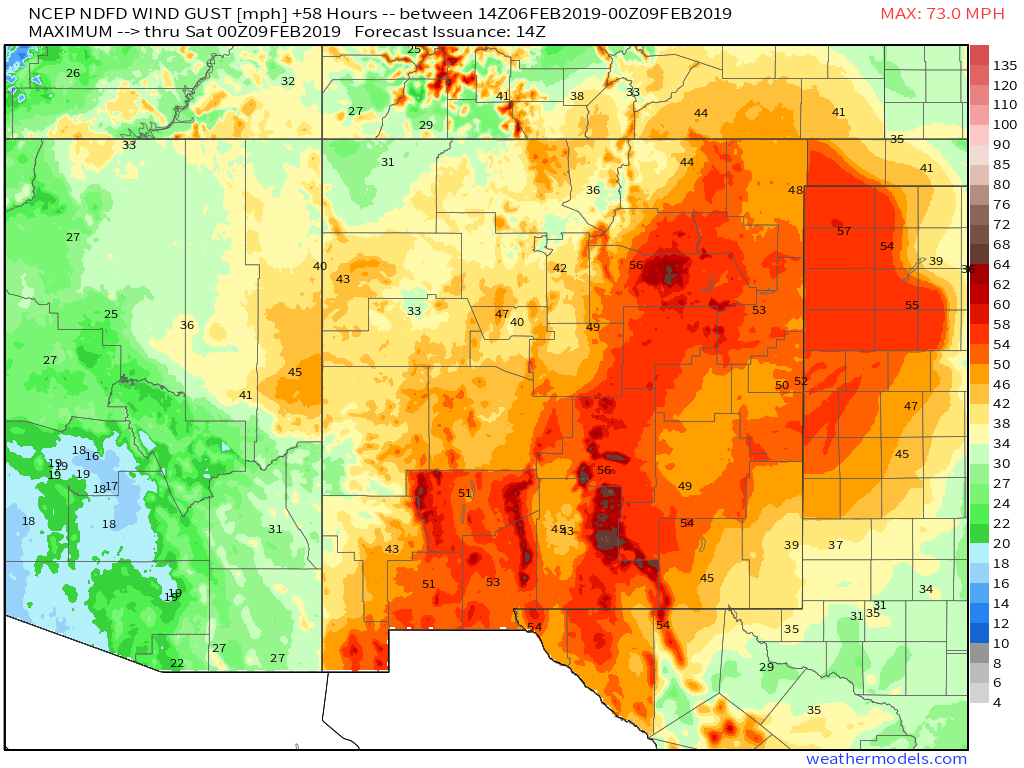
To the south, winds will be cranking up as low pressure develops over Southern Colorado. As winds move down off the Rockies, they accelerate to fill the lower pressure area that exists in the lee of terrain barriers. The result will be gusts ranging from 50 to 70 mph across much of eastern NM and western TX. This will be enough to make driving high profile vehicles tricky, and could also lead to scattered power outages.
More info: Elk NM EPS wind gust forecast (data for anywhere via search box), current wind gust observations
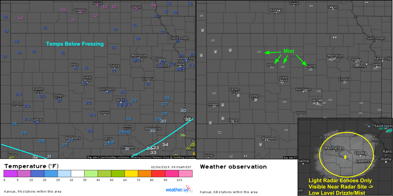
Moving a little off to the east, our next issue is freezing drizzle in the Plains. Current observations show mist across most of Kansas and northern Oklahoma as temps are below freezing. Radar imagery out of Topeka Kansas shows light returns only near the radar site. Remember the beam is flat while the earth is not. As the beam travels away from the radar site, the earth curves away below it, meaning it samples a part of the atmosphere higher and higher off the ground. The beam height where the echoes are no longer visible is about 2,000 feet, further highlighting the low level nature of this drizzle. Farther north in Nebraska, rain is being reported with temps in the low 10’s. The low temps mean any liquid contained in the rain/drizzle will freeze on contact. Even though this won’t be enough ice to bring down power lines, it’s more than enough to make travel treacherous!
More info: KS current observations (change parameter via menus, click on station reading for recent history), Topeka forecast graph (available for anywhere via search box)
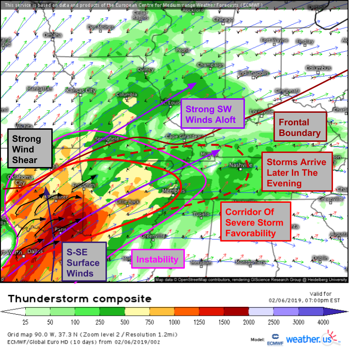
Next on the list of impacts is severe storms. On the southern side of the developing low, we’ll have an environment conducive for severe storms. A frontal boundary will be draped from OK through MO and up the Ohio Valley, and to the south of it we’ll have an airmass from the Gulf of Mexico. That warm moist air will result in instability especially across SE OK/NE TX just ahead of an approaching cold front. Winds in this area will be southerly/southeasterly at the surface, but southwesterly aloft. This will set up strong wind shear which is another ingredient key for severe storms. Storms will develop first in southwestern parts of the area to watch before moving NE towards the Southern Ohio Valley later in the evening. The wind shear will be strong enough to be concerned about some tornadoes, but damaging winds will be the main threat along with large hail.
More info: ECMWF thunderstorm composite, 1-minute satellite imagery, HD radar, current observations, high resolution model forecasts
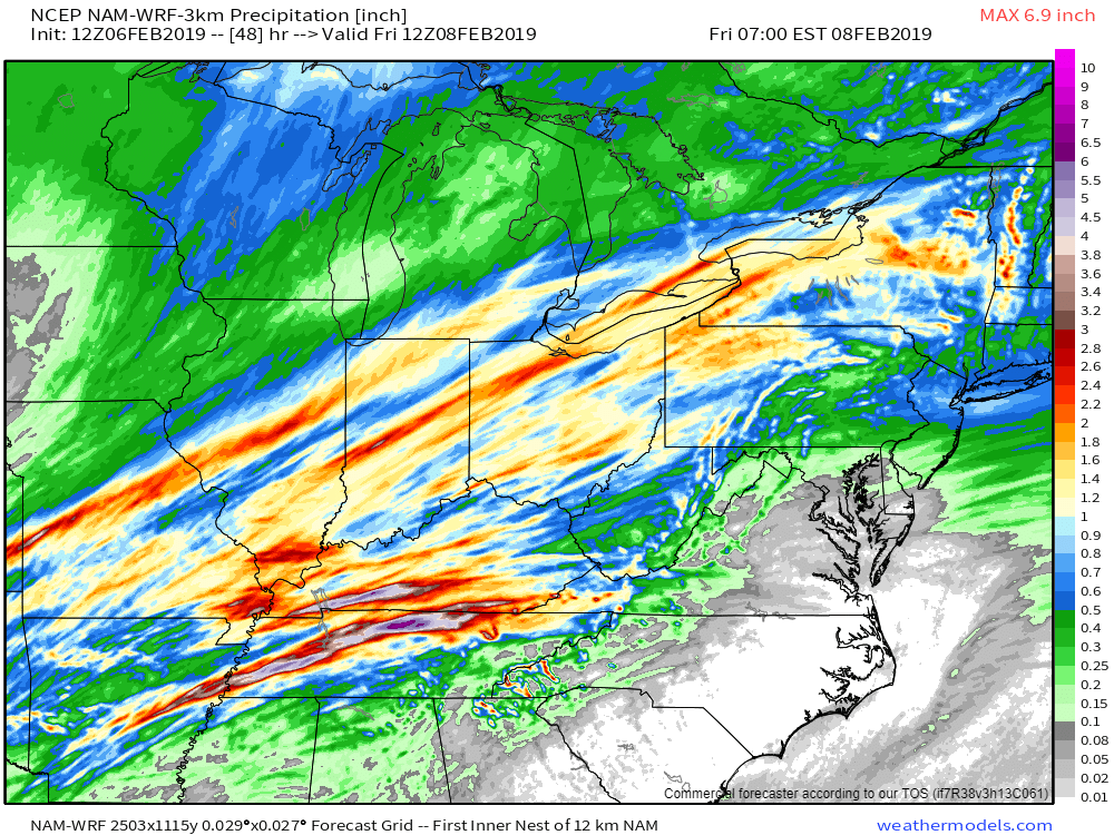
Our next stop is in the Ohio Valley where very heavy rain is forecast to fall along that frontal boundary mentioned above. High resolution model forecasts show a general 1-3″ of rain, with isolated 4-5″ amounts possible where the strongest storms develop. The model is technically forecasting a max of 7″ but that can likely be discounted as this particular model is notorious for overdoing extreme precipitation events. Nevertheless, rivers are already fairly high in this area and minor-moderate flooding is expected over the next couple days. Low lying areas susceptible to inundation should be preparing for some flooding before dry weather returns on Friday.
More info: HD radar, high resolution model forecasts, Louisville rain forecast graph (available for anywhere via search)
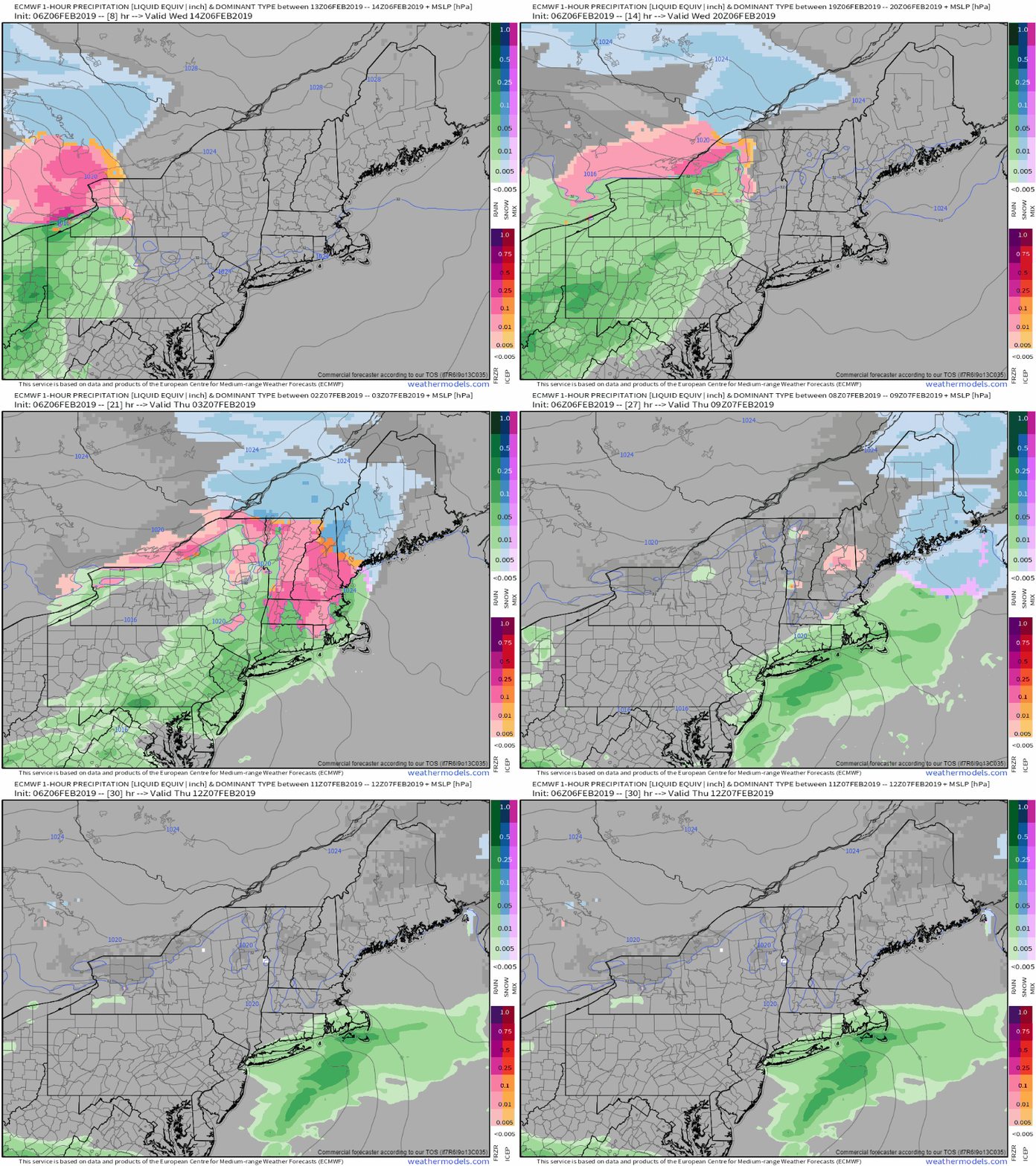
Our final stop this morning is in New England where a weak disturbance will bring mixed precipitation today and tonight. Cold air has seeped in at the surface behind yesterday’s cold front, but warm air remains in place aloft. The result will be freezing rain for parts of Upstate NY, VT, NH, and MA. Maine is deeper into the cold air being farther northeast, so they’ll see primarily snow with 1-3″ of accumulation. Farther south, ice amounts will generally fall around a tenth to possibly as much as a quarter of an inch. This won’t be enough to cause major power disruptions, but widely scattered outages are possible. It will be enough though to cause major travel problems for anyone out and about. Even though the model is forecasting an end to precipitation tomorrow morning, freezing drizzle could persist through the day especially farther north in NH/VT/NY.
More info: composite radar imagery, current observations, high resolution model forecasts
This system will continue to bring impactful weather tomorrow as it moves east through the Plains. More details on tomorrow’s weather will be posted tomorrow morning.
-Jack
