Snow And Ice Expected To Slow Travel Tomorrow Through Sunday In Parts Of The Interior Northeast And Ohio Valley
Hello everyone!
I’ve been discussing a winter storm in the Ohio Valley and interior Northeast for a couple days now. Back on Tuesday, I highlighted the potential for a winter storm in this area, and talked about how the forecast was still fairly uncertain. Yesterday, I talked about how the forecast was slowly becoming more confident, and briefly highlighted some of the impacts expected as the storm develops and moves northeast. I also discussed some of the meteorology behind the overall setup, including what trends I was seeing that supported my forecast track/intensity for the storm. Today, I’ll leave the overall setup behind a little bit to dig deeper into the impacts expected in specific areas.
Our Radar Composite map (click the map to zoom in to see HD data for a specific area) shows two areas of organized precipitation this evening, with scattered showers spread out over a much wider area. The two areas of organized precip are associated with our the two storm systems we’ve been discussing, the first that is now moving into Canada, and the second that is developing over Eastern Texas and Western Louisiana. The scattered precip between the storms is a reflection of the tropical moisture streaming north from the Gulf of Mexico. There’s not much rising motion in this area, but when you have so much moisture, you don’t need much lift to generate scattered precip. The final feature of note on radar is the Arctic front that connects the two storms. As this front plows east, it will clash with the tropical airmass currently streaming into place on either side of the Appalachians. The result will be heavy snow, sleet, freezing rain, and rain, despite the core of the storm being fairly weak.
I want to take a closer look at this front for a minute, because its structure will play a key part in the weather expected across the Ohio Valley and Northeast over the next few days. Fronts are not two-dimensional lines on a map, but instead can be thought of more accurately as three-dimensional circulations. The maps displayed here are the wind speed and direction forecasts from the ECMWF model at different levels of the atmosphere tomorrow afternoon On each map, I’ve marked the location of the front at that level. The map farthest to the left is the surface map, and in addition to the location of the surface front (blue), I’ve also marked the location of the front at the other levels. This is to help illustrate that this frontal circulation slopes westward with height, at varying slopes. The bottom part of the front has a very steep slope, and there’s hardly any horizontal location change in the first 2,500 feet of the atmosphere. However, as you move towards 5,000 and 10,000 feet, the slope of the front becomes much shallower. What does that mean for the sensible weather underneath the frontal circulation?
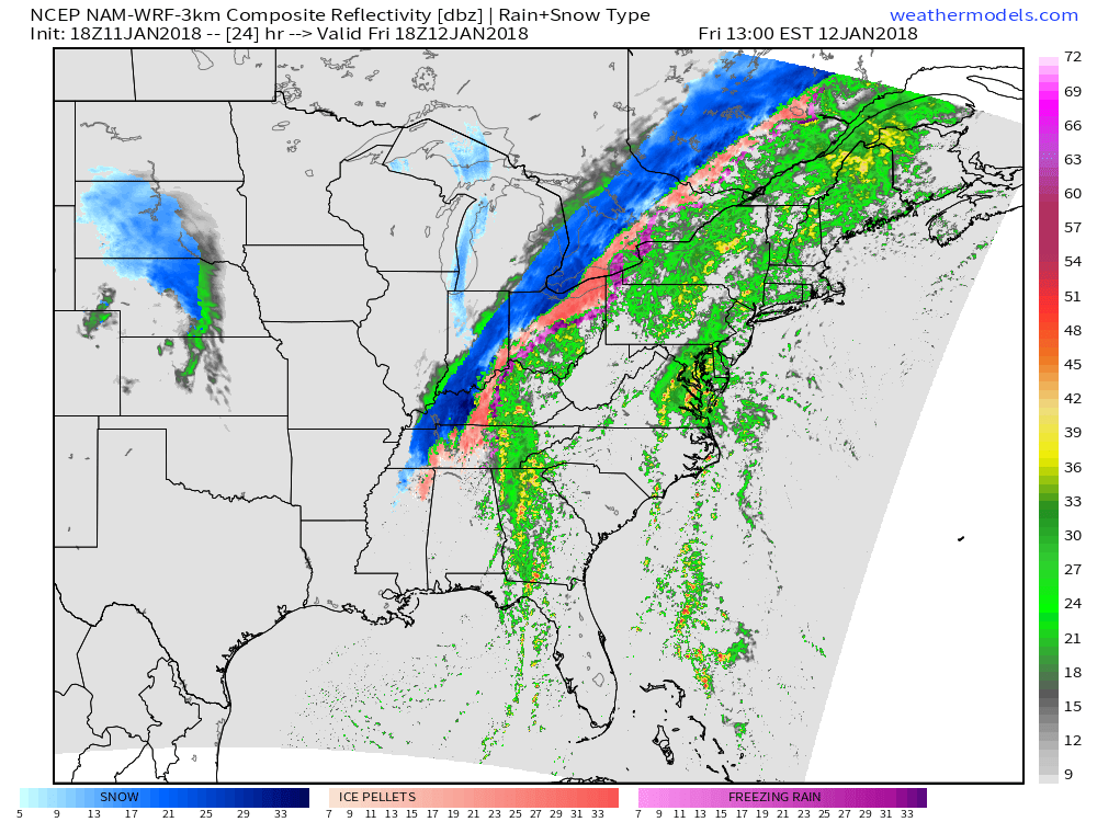
Here’s the NAM model’s simulated radar map for the same time tomorrow afternoon (1PM EST/12PM CST) as the maps above. Notice the distribution of precipitation types near the front. For a wide swath of the Ohio Valley, surface temperatures will be cold enough for frozen precipitation, but there will be a warm layer somewhere in the mid levels to prevent snow, at least early on. Once we have this setup established, precipitation type depends primarily on the depth of the near-surface cold layer. The deeper that layer, the more likely raindrops falling out of the warm layer will refreeze into ice pellets (sleet). The shallower that layer, the more likely that liquid raindrops will make it to the surface, where they will freeze on contact with cold surfaces (freezing rain). The steep frontal slope in the bottom 2,500 feet of the atmosphere suggests a fairly deep near-surface cold layer. This would support more freezing rain than sleet in the mixed precipitation zone. Eventually, as you head far enough west, the front reaches so high into the atmosphere that even those on the “warm” side have temps below freezing, allowing for snow.
Map from weathermodels.com.
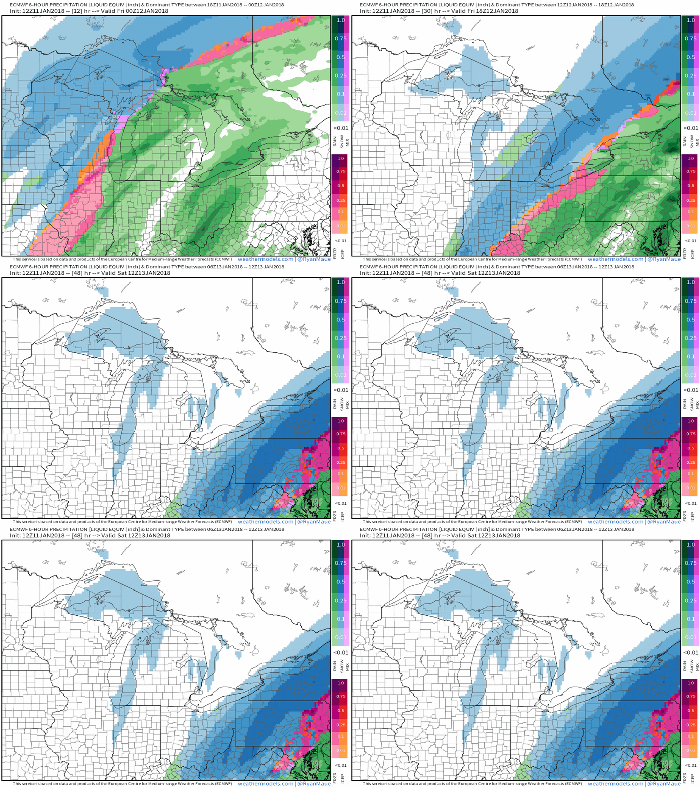
Here’s an animation of the ECMWF’s precipitation type forecast showing that mixed precipitation zone shifting east during the day tomorrow as cold air pours in behind the Arctic front. Ahead of that mix zone, heavy rain will cause some flooding problems, especially in parts of Southern New England. Behind the mix zone, accumulating snow is expected, with some parts of far western NY possibly seeing up to a foot of snow, not including any lake effect behind the system. In the areas impacted by the mix zone (including much of the Ohio Valley and interior Northeast), expect ice accretion of between a tenth and a third of an inch, depending on the exact structure of the front as it crosses your area. This is more than enough to cause extremely slick travel, but should fall just short of what’s needed for widespread power disruption, though scattered issues of that nature are possible. In addition to the ice, also expect sleet, which could accumulate to a very dense inch or so, on top of the ice, and underneath the final coating of snow that falls after all the warm air has been pushed southeast.
Map from weathermodels.com.
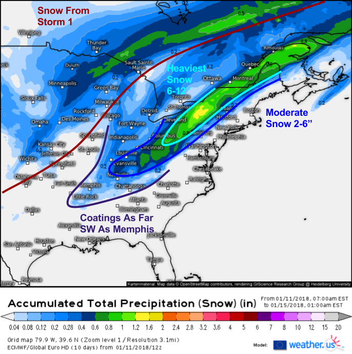
Speaking of snow, here’s an overview of how much to expect. The heaviest snow will fall in Western New York and Pennsylvania, with amounts over 6″ also possible in the far northern parts of New England. Much of the rest of the southern/central Ohio Valley will see moderate accumulations of 3-6″ while coatings could fall as far SW as Memphis. There will be a sharp cutoff in terms of snow amounts just NW of the I-95 corridor as the cold air will be racing the back edge of the precipitation to the coast. For more detailed snow forecasts for your area, check out the ECMWF map I used above, which is how much QPF the model forecasts to fall as snow (click for more information on QPF and using it to forecast snow totals) and click the map to zoom in. You can also explore our Forecast Ensemble product which will help give you a sense of the uncertainty in the snow forecast for your town.
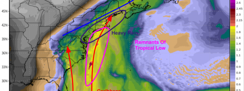
While mixed precipitation causes problems along the front, and snow has a similar effect behind the front, tropical moisture surging north will bring heavy rain and flooding concerns into the picture for parts of Southern/Coastal New England tomorrow. A tropical low that has been gathering moisture over the Gulf of Mexico for the past few days will get swept up into the developing storm, decaying along the way. The remnants of this system are visible in ECMWF precipitable water forecasts for tomorrow evening. Precipitable water is a measure of how much moisture is stored up in any given part of the atmosphere. PWAT values above 1.5″ indicate an extremely moist airmass for this time of year, and that’s what’s forecast to move through New England.
Map from weathermodels.com.
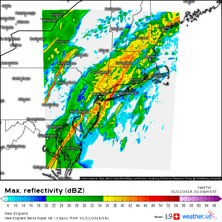
Given the strong front in the area, and the deep supply of tropical moisture, it’s no surprise that the Swiss Super HD model is forecasting some very heavy rain tomorrow afternoon. Downpours will impact areas from New Jersey to Maine, and in areas with snowpack still left over from the blizzard, flooding will be a concern due to the combination of heavy rain and snowmelt, as well as the added effects of snow clogged storm drains. Total rainfall of 1-3″ is expected before the front arrives and changes precipitation to freezing rain and/or sleet on Saturday.
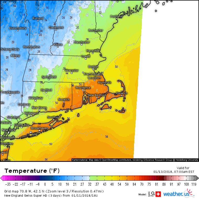
Just because most of the precipitation in Southern New England will fall as rain, that doesn’t mean they’re out of the woods in terms of icy conditions. Swiss Super HD model forecasts for Saturday morning show an impressive temperature gradient across the area as the front moves through. Temps will drop around 30 degrees in just a couple hours as the cold air rushes in. This sharp drop from the mid 50’s to the mid 20’s will result in all the puddles that formed as a result of the rain freezing up in just a couple hours. These “flash freeze” events are notorious for producing very slick conditions, even after precipitation has ended. Add the potential for some snowflakes as the storm departs and you have a recipe for very slick roads all across New England on Saturday morning.
Model guidance has precipitation moving out of New England Saturday night, however there are hints that perhaps we could be in for a little bit of a “surprise” snow where the departing precipitation shield slows down a bit more than expected.
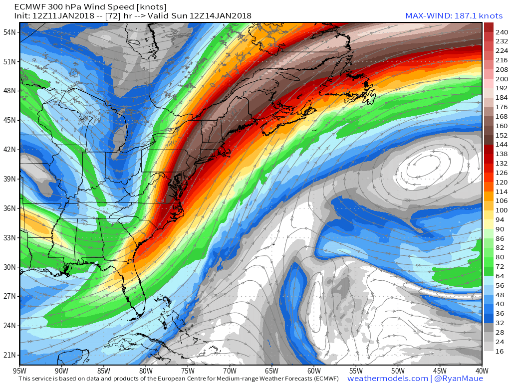
Here’s the ECMWF’s jet stream forecast for Sunday morning. Notice the very strong jet streak (area of especially fast winds embedded within the larger jet stream) stretching from Eastern NC through the Canadian Maritimes. This jet streak bends to the right, meaning it’s anticyclonically curved (winds bend clockwise, or anticyclonically, as they traverse the jet). The right entrance region of anticyclonically curved jets are known to favor rising motion. With the Arctic front still lingering not too far offshore, we could have just enough moisture to get squeezed out by that lifting and produce snow. The setup isn’t right for a major storm, and accumulations would total a couple inches at best, but a couple inches of snow on top of flash-frozen roads would make an already slippery situation much worse.
Map from weathermodels.com.
Quiet weather will return (albeit probably briefly) Sunday afternoon into Monday.
Our next storm to watch will likely take shape in some form or another during the middle part of next week.
-Jack


