Significant Heavy Rain Expected To Continue In Parts Of The Southern Mississippi Valley Tomorrow
Hello everyone!
The high amplitude pattern discussed back on Sunday has fully taken shape over the past couple days, and will continue to dominate the weather from coast to coast today. It will be in the battleground between unusually cold temps in the west and record breaking warmth in the east that the most active weather will be found. An area of heavy precipitation is ongoing in the southern Mississippi Valley this morning. Along the NW fringes of this precip, look for ice accretion to continue across parts of Oklahoma, Missouri, and far NW Arkansas. Areas farther south and east will see torrential downpours capable of impactful flooding.
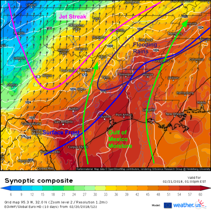
Here’s a look at the setup for today’s heavy rain as depicted by the ECMWF’s synoptic composite product (what’s that?). The first feature to notice is the strong jet streak extending from Central Texas up through Oklahoma and into the Plains. The right entrance region of this streak is located from SE MO through AR and into NE TX, and will both provide background lifting for storms as well as help to “vent” air away from the tops of those storms so they have room to continue developing. Also notice the deep supply of Gulf moisture in the area, and the surface front to help focus the lift needed to squeeze that out. We have all the ingredients we need for a flooding event from NE TX through AR and into NW AL/W TN.
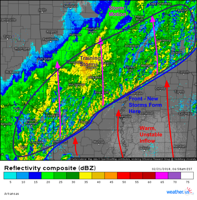
Composite radar imagery shows the results of these processes already in progress across the areas discussed above. The frontal boundary can clearly be seen stretching from Shreveport Louisiana through far SE AR and into far NW MS. New storms are constantly developing here as warm, moisture rich Gulf air streams north into the approaching cold. Once storms develop, they feel the influence of the strong jet and race north, becoming elevated over the low level cold. However, with such deep moisture and impressive jet dynamics, even as the storms slowly die out, heavy precipitation can blossom well behind the front as shown by that wide swath of heavy rain in Central AR just NW of Little Rock.
You can see all these features even better on the looped radar imagery, and if you’re interested in HD imagery you can use the blue “HD” button at the top of the map to view higher resolution imagery from a specific radar site instead of the SD composite. The other blue buttons let you select other radar options, such as velocity data, storm tracking, and lightning among others. Even more options such as echo tops and vertically integrated liquid can be found via the menus to the left of the image. Click to zoom into county level for an even closer look at any specific cell.
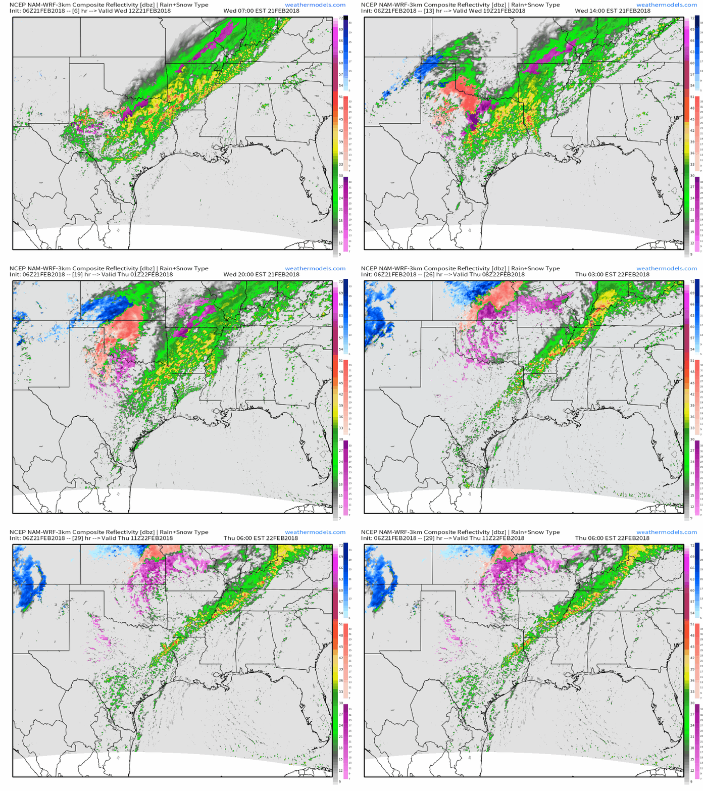
This simulated radar GIF from the NAM on weathermodels.com shows heavy rain not letting up today across the areas discussed above. Even as the cold front sinks farther and farther south, an upper level disturbance over Texas will move east today, bringing a renewed source of moisture and lift to the region. That disturbance will also reignite wintry precipitation across parts of North-Central Texas, Oklahoma, Kansas, and Missouri as shown by the widespread pink (sleet) and purple (ice) colors on the maps above.
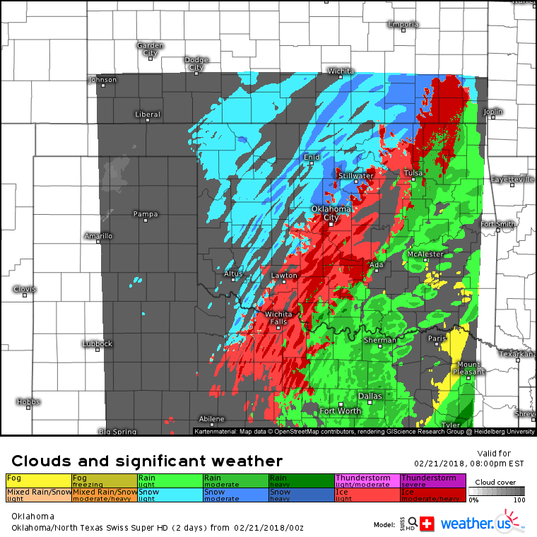
Swiss Super HD model forecasts give a good sense of where to expect wintry precipitation this evening in North-Central Texas and Oklahoma. Some of the precipitation the model is forecasting to fall as snow is likely to fall as sleet or freezing rain due to very warm temperatures just above the surface. In the Southeast corner of Oklahoma and the Northeast corner of Texas, heavy rain is expected to continue with temps above freezing. While mid level temps will limit snow potential in Oklahoma, flakes are likely to fly farther NW in parts of Kansas though accumulations should remain minimal.
Here’s an animated GIF from weathermodels.com showing the ECMWF’s forecast for how much liquid equivalent is expected to fall as freezing rain in six hour increments from this morning through tomorrow afternoon. The heaviest amounts are expected in Central and Western OK, as well as Southeast KS. Additional ice accretion between 1/10″ and 1/4″ is most likely in these areas, with locally higher amounts possible. Wintry precipitation will depart tomorrow as that system moves northeast.
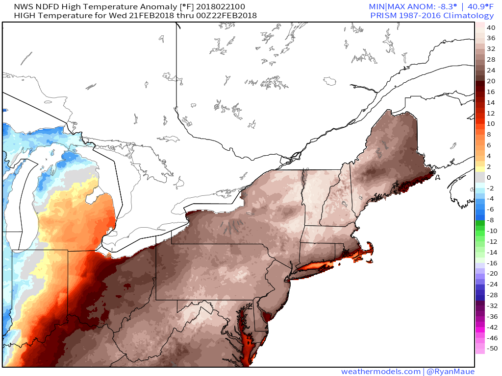
In the East today, temps will soar well above what’s typically expected for this time of year. Highs in the 70’s are expected all the way into New England which translates to temps 20-40 degrees above normal! The opposite is expected in the West, where temps will remain well below normal under a large upper level trough. Map from weathermodels.com.
For more information on what to expect in your town today, check out our Forecast Essentials product, now with ECMWF data! https://weather.us/forecast/essentials
For more information on the local forecast for ME/NH: https://forecasterjack.com/2018/02/21/astoundingly-hot-today/
-Jack
