Severe Weather In The Southeast Today
Hello everyone!
Today’s main weather story will be severe thunderstorms forming in the Southeast in advance of a strong upper level disturbance moving eastward. Some storms are already ongoing in this area this morning, but the main event will be later this afternoon into this evening. During that time, new storms will form and quickly take advantage of a favorable environment to organize into supercells. These supercells will be capable of all severe hazards including damaging winds, large hail, and tornadoes, in addition to the standard thunderstorm hazards of frequent lightning and torrential downpours.
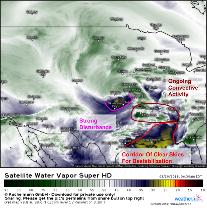
Here’s a look at this morning’s GOES-East water vapor satellite imagery (what’s that?) which shows a few features important to storm development later today. Our main disturbance is located back across the Southern Plains this morning, but is moving quickly east. Leftover convection from yesterday’s storms is noted across parts of the Deep South from Arkansas back through Tennessee and northern Mississippi/Alabama. In order for any higher end severe threat to materialize this afternoon/evening, the plume of slightly drier air aloft needs to move north a bit to allow for sunnier skies in Northern AL/Southeastern TN which would result in destabilization of the atmosphere, and thus more fuel for thunderstorms.
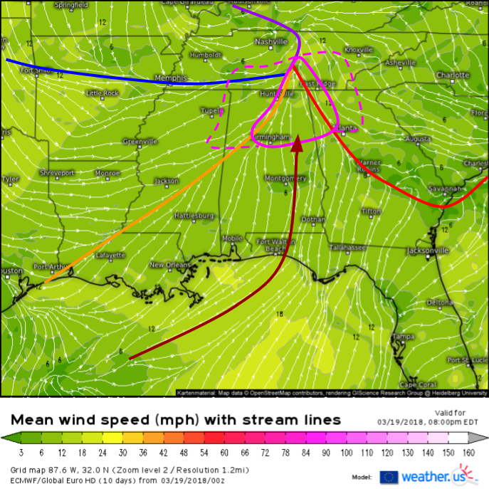
The ECMWF’s surface wind forecast highlights how several surface features will contribute to focusing the severe threat in Northern AL and Southern TN this evening. A warm front located in Alabama this morning will lift into Georgia this afternoon, allowing unstable air to flow north towards the Tennessee border. A subtle wind shift associated with the remnants of yesterday’s dryline feature over Texas will help to focus storms well ahead of the cold front which will lag well to the north and west. It’s between the dryline and the warm front in Northern Alabama that the best combination of ingredients will be present for severe weather today. Notice that in this area, surface winds are “backed” and contain more of a southerly component than a southwesterly component. This “backed flow” helps enhance wind shear and turning in the atmosphere by increasing the change in wind direction with height. This backed flow is present to an even greater degree over NE GA and SC, but those areas are ahead of the warm front and thus have very limited instability. The same is true across much of TN, though there may be enough instability there to result in some severe storms.
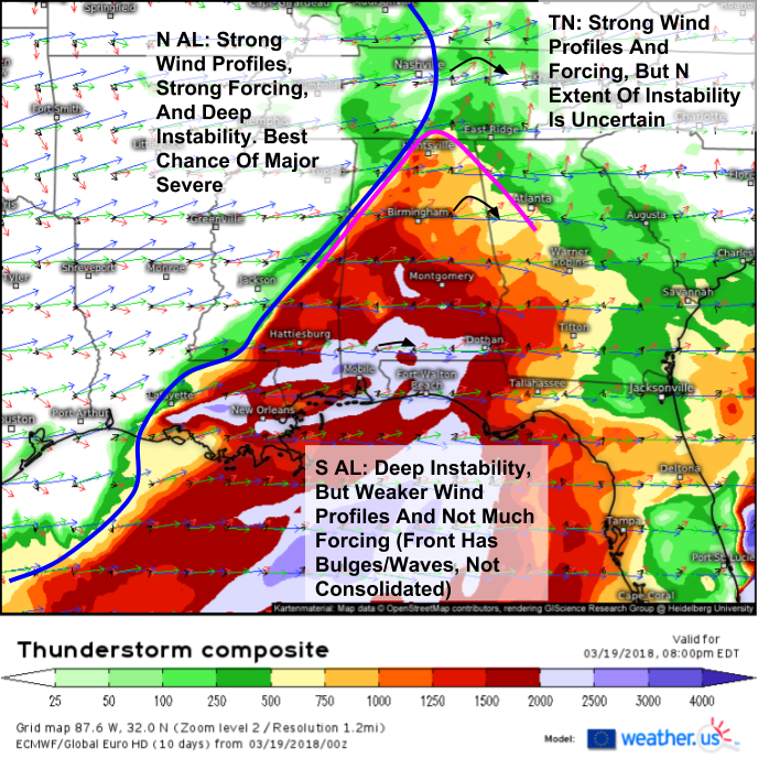
The ECMWF’s thunderstorm composite map (what’s that?) for this evening is a great way to highlight how each of the three severe ingredients are present with this setup, but they only overlap in a very small area. Wind profiles in Tennessee are textbook for supercells, and forcing along the front/dryline there will be more than strong enough for storm formation. However, there’s very little available instability. As a result, the severe threat will be muted. The opposite problem arises farther to the south, along the Gulf Coast. In this area, there’s more than enough instability for storms, but frontal forcing is much weaker, and wind profiles are also much less impressive due to the fact that the area is farther removed from the dynamics associated with the upper level disturbance moving through TN. It’s only in Northern AL that each of the ingredients is really present enough for a major severe threat.
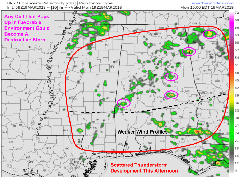
HRRR simulated radar imagery shows storms getting going this afternoon in parts of the south as daytime heating destabilized the atmosphere. Any initial discrete cells that pop up in North-Central Alabama may evolve into dangerous supercells given the supportive environment. However, given limited forcing ahead of the front, activity will be fairly scattered. The more widespread dangerous storms will show up later in the evening. Map via weathermodels.com.
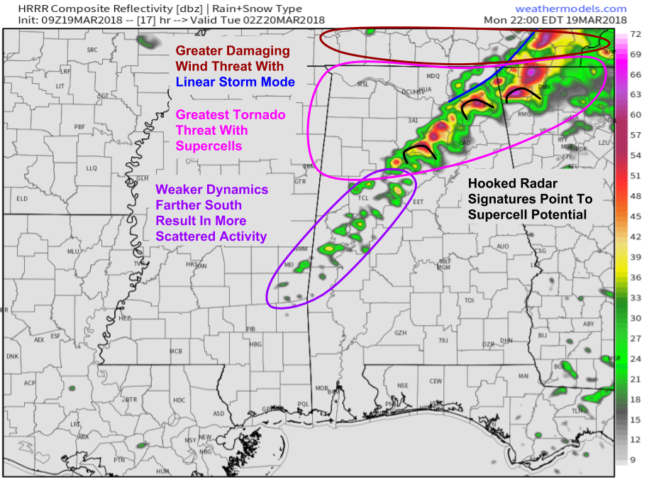
This simulated radar image valid at 10 PM EDT shows the setup to be concerned about in Northern Alabama with a more widespread series of supercells capable of damaging winds, large hail, and strong tornadoes. The northern edge of this line will quickly evolve towards a linear storm mode with damaging winds becoming the main threat especially into TN. Farther south, weaker dynamics will result in weaker and more scattered activity, though any storm could become severe even outside the area of greatest threat. Activity will weaken and shift east into the Carolinas overnight. Map via weathermodels.com.
Once storms form this afternoon, track them with the wide array of tools we have at weather.us. Watch small cumulus clouds grow into towering thunderstorms with 1 minute GOES-East satellite imagery https://weather.us/satellite/alabama/satellite-superhd2-1min.html#play2, find the cores of the strongest storms with HD radar imagery https://weather.us/radar-us/alabama/reflectivity/KBMX.html#play, and see if they’re spinning with HD velocity data https://weather.us/radar-us/alabama/velocity/KBMX.html#play. Finally, watch current observations to keep tabs on the building instability, as well as the location of important features such as the warm front and the dryline. Current temps https://weather.us/observations/temperature-f.html dew points https://weather.us/observations/alabama/dewpoint-f/20180319-1200z.html and wind direction https://weather.us/observations/alabama/wind-direction/20180319-1200z.html will be the parameters that will be most important today. Click the refresh button at the top left of the image to get the latest data. Click any of the maps at the links to zoom into county level for a closeup look at what’s happening in your neighborhood.
For more information on your local forecast: https://weather.us/
For more information on the local forecast for ME/NH: https://forecasterjack.com/2018/03/19/feeling-like-january-today/
-Jack
