Severe Weather Expected In The Mid South Today
Hello everyone!
Today will feature a fairly widespread severe weather outbreak across the Mid South as a strong storm system moves through the Northern Ohio Valley. Thunderstorms are already ongoing in western parts of the region this morning as storms that formed last night over OK and TX move east. Behind these storms, another round can be expected along the system’s cold front later this afternoon/evening. Those are the storms with the greatest potential for severe weather. Additionally, a subtle pre-frontal trough in N MS/AL could help provide the impetus for more isolated severe storm development ahead of the main line. Any storms that develop along this feature are liable to produce strong tornadoes due to their discrete nature and favorable environment. This post will outline what to expect from these storms through the day today, and will also explain some of the meteorology behind the forecast setup.
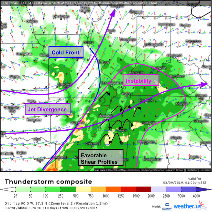
Here’s a look at the overall setup, which is excellently visualized by the ECMWF’s thunderstorm composite map. Features to note include the strong jet divergence, the cold front, and the very favorable shear profiles out ahead of the cold front in an area of modest instability. This map does a good job highlighting why I think today’s threat comes in two parts. In the northern part of the instability pool, notice that winds are much stronger at all levels. The wind profiles (what do I mean by wind profiles? The black arrows, connecting the ends of the wind vectors at different heights) are also a bit more linear, pointed parallel to the direction of the front (SW-NE). What does all that mean? Air parcels lifted along the front will remain fairly close to the front. Why is that important? It is a setup much more favorable for a line of storms compared to discrete cells. Farther south, shear profiles are far more rotational through the whole atmosphere, and winds are generally more perpendicular to the front. That means that air lifted along the front that becomes a storm, has the potential to move off the front into the warm sector, becoming its own entity. Those discrete cells are more capable of becoming supercells, and thus producing long track tornadoes.
Here’s a look at the environment’s rotational energy this afternoon. There will be no shortage of rotational energy in the atmosphere across the entire threat area, including the part of MS/AL favored for discrete storm modes. That’s where the best chance of a long track tornado will be, especially the northern part of that area. To the east, a cold wedge will develop down the east side of the Appalachians, which will mark the eastern bound of environmental favorability for supercells. Farther north in TN/KY/IL/MO where the storm mode is expected to be predominantly linear, there will also be plenty of rotational energy. This will present a different but no less dangerous tornado threat along the leading edge of the line. It’s not difficult to get short-lived but fairly strong tornadoes on the leading edge of lines given favorable environmental conditions. That said, the most widespread threat from the line will be damaging winds.
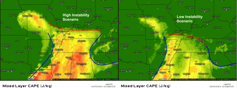
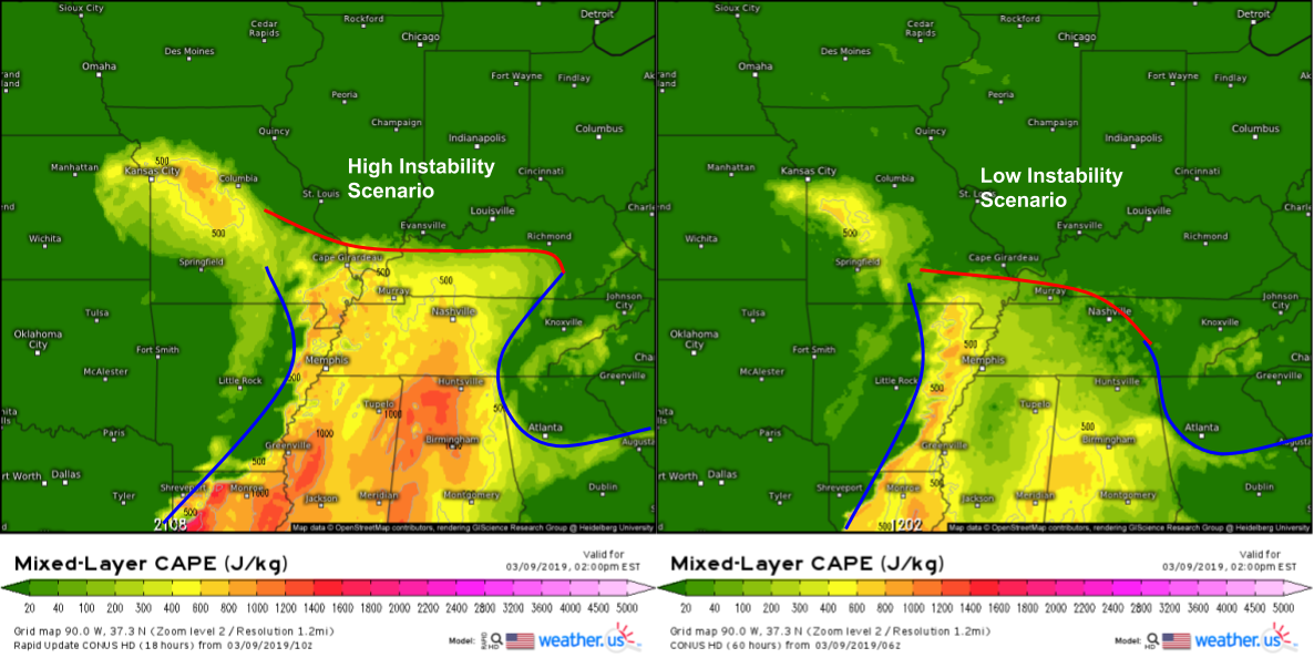
So is there any uncertainty in this setup? Of course! Here are two model forecasts for the same parameters (instability) for the same time (1PM CST). One forecast calls for robust instability to build across the entire severe risk area, while the other model suggests instability may in fact be quite limited. Why is this? The model on the left is different from the model on the right in three important ways elsewhere in the suite of forecast products. First of all, it produces a bit more sunshine across the forecast area, which enables heating of the low levels. Warmer air is less dense, which makes it more unstable if lifted. Second, it brings more moisture farther north, which also increases parcel instability. Why? I explained in yesterday’s discussion, so check it out if you missed it! Finally, it has cooler mid level temperatures, which heighten the contrast between surface parcels and the environment they get lifted into. The combined effect is much more instability, and thus a much more robust chance for intense severe weather. That said, even if the lesser instability forecast ended up verifying, there is enough energy forecast there for strong to severe storms, just not quite at the scale as the higher instability option. Find the comparison helpful? You can easily compare different models at weather.us via the blue buttons at the top of the map.
We’ll be able to know a little later this morning which forecast is most likely by carefully analyzing satellite imagery and current observations, both of which you can find at weather.us.
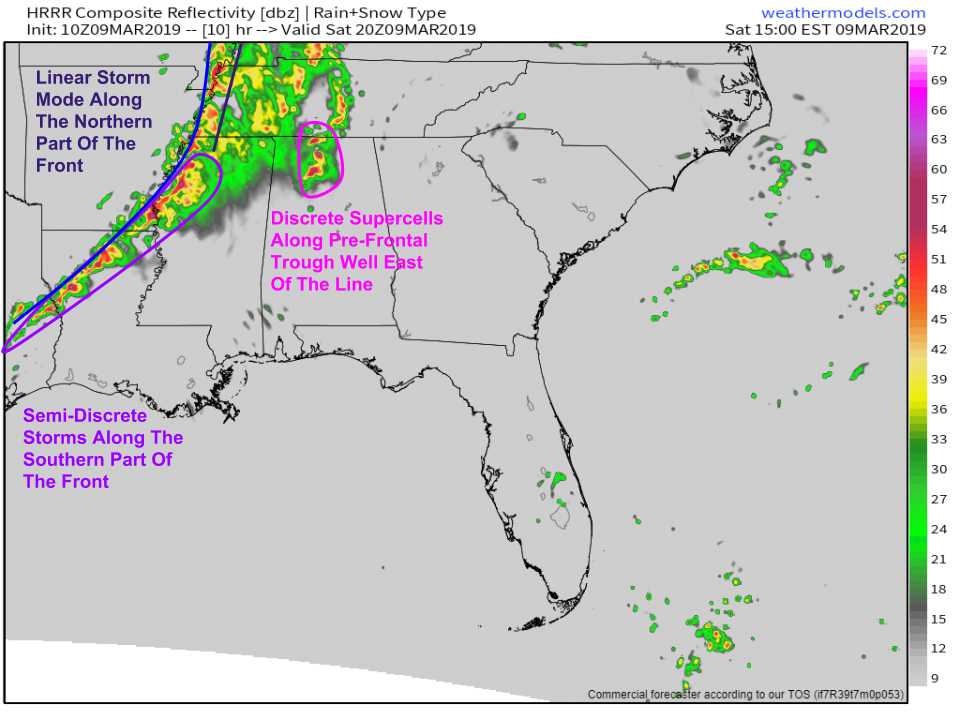
Here’s a look at one model’s simulated radar for this evening. While it’s not a perfect representation of what I think is most likely to happen, it’s a good starting point. Note the line of storms along the front, becoming a little more discrete as you move farther south. Tornadoes, strong winds, and hail will all be threats with these storms, but damaging winds are likely to be the biggest issue. Farther east, the model has forecast several discrete supercells initiating along a weak boundary known as a pre-frontal trough. These storms, if they do indeed get going, will pose the biggest risk for a violent long-track tornado. We’ll be watching closely today to see if those cells do materialize, and if the environment is sufficiently favorable for them to produce strong tornadoes. As of now, all indications point to that threat being quite plausible. Simulated radar imagery via weathermodels.com.
Keep an eye on storms as they evolve today with satellite imagery, HD radar imagery, and current observations at weather.us.
-Jack


