Severe Storms To Develop Across The Ohio Valley This Evening
Hello everyone!
A strong upper level low is dropping southeast across Wisconsin today, and out ahead of it, strong to severe storms are expected across much of the Ohio Valley. I’ll dig into the setup in this post, with explanations of what to expect, as well as some of the scientific processes behind the forecast. If you’re looking for a quicker overview, check out John Kassell’s latest post.
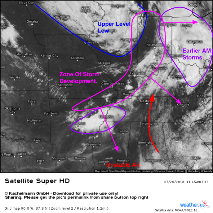
Here’s a look at visible satellite imagery across the Ohio Valley, as of a little earlier this morning. The upper level low (which will bring forcing/shear) and the sunshine/southerly flow (which will bring instability) responsible for today’s favorable severe weather setup are both visible, along with the remnants of some earlier storms. GOES-East will continue to be a very valuable asset in tracking today’s storms, and there’s even one minute coverage of the severe risk area so you can watch each and every cloud bubble up in near-real time. Watch for the speckled areas (such as those NW of Atlanta) that indicate low level cumulus clouds. Once those clouds start to bunch together, and begin moving more easterly than northerly, you’ll know storm development (known formally as “convective initiation”) is imminent.
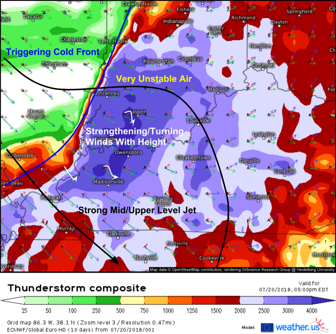
You probably knew a map like this was coming. The ECMWF’s Thunderstorm Composite map is an incredibly valuable tool to analyze all three elements important to severe thunderstorm formation/development – instability, shear, and trigger. All three ingredients are clearly present, with CAPE (Convective Available Potential Energy, also known as thunderstorm fuel) in excess of 4,000 J/kg in some areas, and in excess of 2,000 J/kg across nearly the entire region. While high CAPE values alone aren’t enough to guarantee severe thunderstorms, these values indicate a volatile atmosphere conducive to severe thunderstorm development, if the trigger/shear elements are in place.
The wind profiles (colored vector arrows) highlight both the cold front (change from southerly to westerly surface winds, shown by black arrows) and the strong mid/upper level jet in place from Southern Indiana down towards Tennessee. These strengthening and veering (turning towards the west with height) will help strengthen and organize the storms that the cold front touches off.
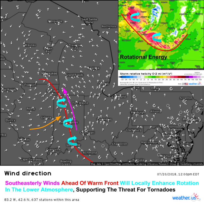
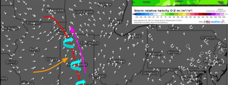
Wind direction observations and forecast data from the high resolution NAM model highlight an additional feature that will be important to watch through the rest of this afternoon into this evening- a warm front draped from Chicago down through Indianapolis and into Eastern Kentucky. Winds ahead of this warm front are out of the southeast, which will further enhance rotational energy in the lower atmosphere. The frontal boundary itself is also a good source of rotational energy, and storms that cross or are able to “latch on” to the boundary will receive an injection of rotational energy, which is sometimes enough to prompt tornado formation, also known as tornadogenesis.
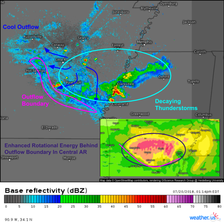
Farther south and west, away from the warm front where southwesterly winds are in place, damaging winds and large hail will be the primary threats though a tornado or two can’t be ruled out, especially in NE Arkansas. The maps above highlight why. Earlier thunderstorms (seen on GOES-East imagery above) have created an outflow boundary that currently resides in Central AR, and is visible on HD radar imagery. Outflow boundaries, much like warm fronts, are sources of rotational energy. If new storms develop in this area later this afternoon and are able to tap into that localized rotational energy, a tornado threat may emerge in spite of the larger scale generally unfavorable southwesterly winds.
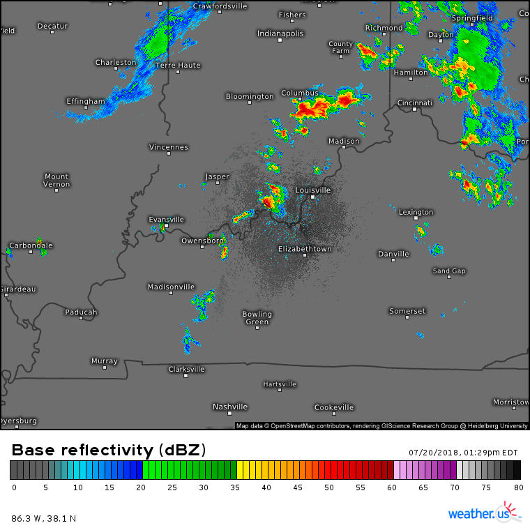
HD radar imagery as of 1:30 PM EDT shows storms already developing in Southern Indiana. Notice how storms are initially discrete, appearing in the form of small cells as opposed to large lines. Discrete storms have the best chance of producing tornadoes, and will continue to pose that threat for the next several hours. As the sun sets this evening though, storms are likely to merge into clusters/lines which will pose primarily a damaging wind threat. Storms will move southeast this evening, bringing the threat for severe weather to places like Alabama during the overnight hours.
Track the storms with the tools we have at weather.us including HD radar imagery, GOES-East satellite imagery, and lightning analysis. Once at those links, click the map to zoom in, or use the (-) button to zoom out. The menus to the left of the image will let you toggle storm tracking options, as will the blue buttons at the top of the images. Strike-specific lightning info can be found by zooming into level 4, then clicking on a specific strike icon (click here for full tutorial).
-Jack
