Severe Storms In The Northern Plains Today As Maria Roars Towards Puerto Rico
Hello everyone!
We have two main weather stories today, severe storms in the Northern Plains, and major hurricane Maria in the Caribbean, headed for Puerto Rico. Jose will be bringing some gusty winds and rain showers to parts of the East Coast, but I’ve already detailed the forecast for that system in previous updates.
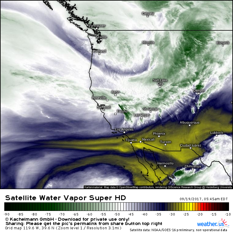
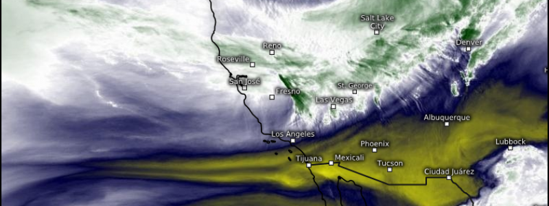
Very strong upper level energy is plowing into the Pacific northwest this morning and will be headed east today. Once it arrives over the Northern Plains where warm and unstable air is waiting, severe storms are likely to erupt. As always, we have three things to look for when assessing severe weather potential: wind shear, instability, and a trigger mechanism. Let’s quickly go over each for today’s potential severe weather in the Northern Plains.
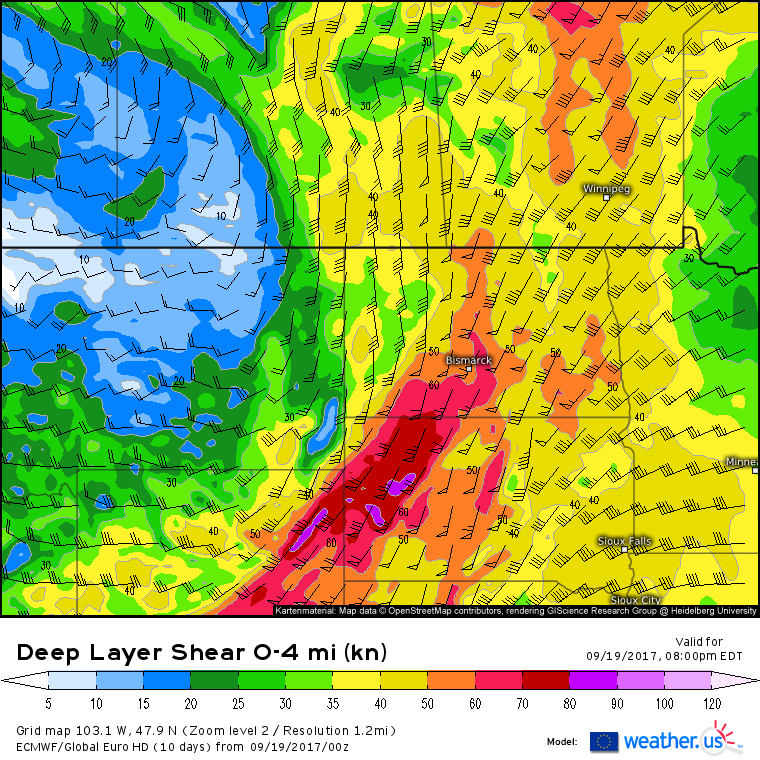
The powerful jet energy visible in the satellite image above will support very high wind shear values. Generally, shear in excess of 35 kts is supportive of severe weather, values above 50 kts are forecast across wide swaths of the Northern Plains. We’ll have no problems with lack of shear today.
Southerly winds will bring unstable air into the region today, and ECMWF instability (CAPE) forecasts show an axis of strong instability across eastern ND/SD and western MN. Given that shear is favorable everywhere, but instability is only favorable in these areas, we can narrow our search for severe weather potential down to the eastern half of both ND and SD, and the western part of MN.
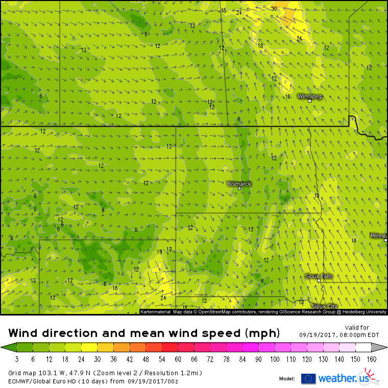
For a trigger, a strong cold front is forecast to be located across the Central Dakotas this evening. SE winds ahead of the front will be transporting in the moist, unstable air, while westerly winds will carry cooler air into the region. Our trigger is set, checking off the last item on our list. It’s safe to assume fairly widespread severe weather will impact this region tonight. Gusty winds and large hail will be threats, as always, but those southeasterly winds over the Red River valley will help to fuel an additional threat, tornadoes. The greatest threat for tornadoes will be in Eastern SD where weaker forcing from the cold front will support more discrete cells, as opposed to a line of storms which is likely to form in ND.
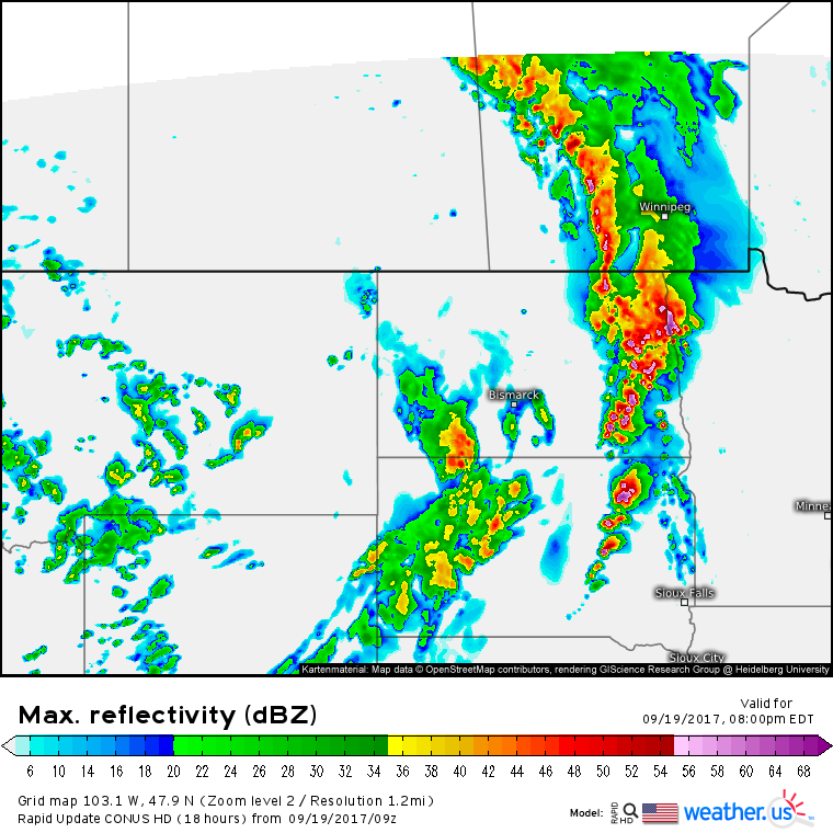
Here’s a simulated radar image from the HRRR model to illustrate the threat potential this evening. Notice the line of strong storms in ND, with more discrete supercell type storms in SD. The line will produce more widespread severe weather including damaging winds, while the supercells will be more isolated in nature, but capable of tornadoes in addition to large hail and damaging winds.
Storms will move east into MN later in the evening before weakening early tomorrow morning.
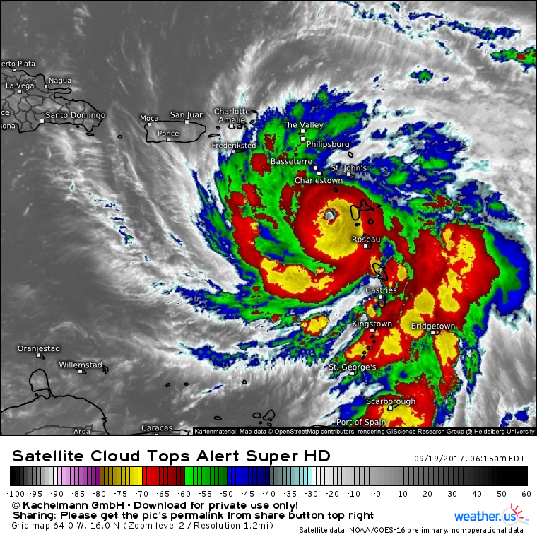
Meanwhile in the Caribbean, Maria is regaining strength after making landfall in Dominica last night.
While interaction with Dominica’s mountainous terrain weakened the system overnight, Maria has wasted no time working to regain its former glory. Satellite imagery shows a clearly defined eye that is surrounded by a ring of very powerful thunderstorms. Outflow in all directions continues unimpeded, and strong spiral bands are forming near the storm’s edge. With warm waters, light wind shear, and little dry air ahead, Maria is unlikely to slow down much if any before reaching Puerto Rico tomorrow.
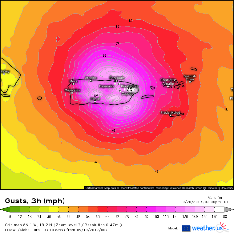
Impacts in Puerto Rico will be nothing short of catastrophic. Maria is likely to make landfall on the island tomorrow as a Category 5 storm. Winds will gust over hurricane force across the entire island with locations near the landfall point seeing gusts well over 180 mph. Winds get higher with height, and Puerto Rico has numerous tall mountains that will see the full force of Maria’s strongest winds. Gusts in the higher terrain could exceed 200 mph. Fortified concrete structures will be able to withstand these winds, but nearly everything else will not. If you’re staying on the island, be sure to line up a place to shelter today!
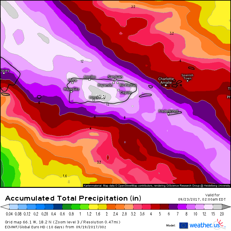
In addition to the destructive winds, over a foot of rain will fall across much of the island. The mountainous terrain will help to squeeze out more of Maria’s moisture, and rainfall totals on the slopes of those mountains may exceed two feet. These torrential rains will drive flash flood and mudslide threats in addition to the winds. All in all, this is shaping up to be a catastrophic storm for the island of Puerto Rico. Any preparations to protect life and property should be rushed to completion today!
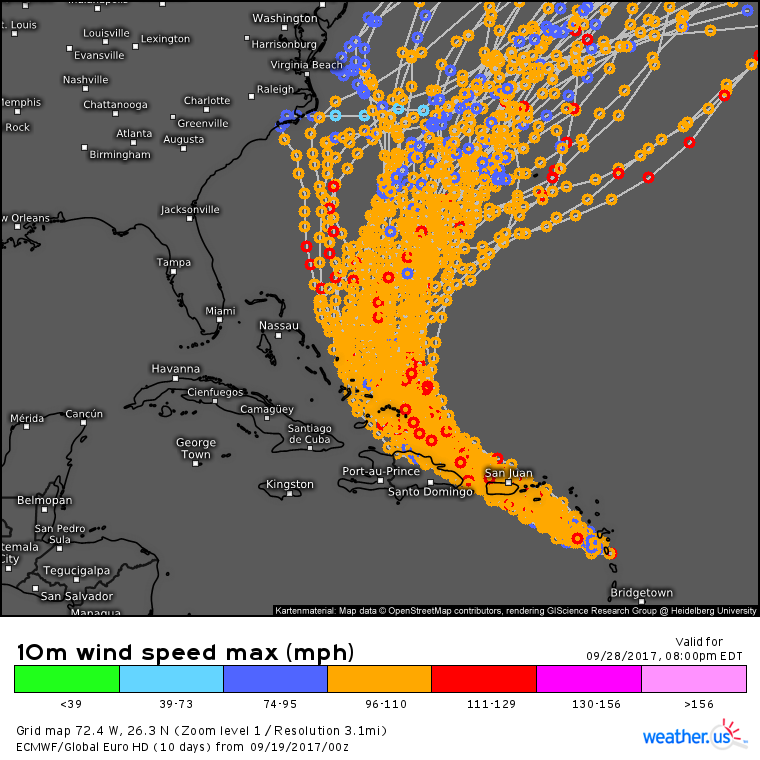
It’s too early to say for sure where Maria will go after Puerto Rico, but indications are that the system will take a turn to the north near the eastern Bahamas before either moving towards the East Coast or moving out to sea. Notice the considerable spread in possible solutions from North Carolina to Bermuda about a week from now. While any potential US impacts remain uncertain, it’s never a bad time to think about what you would do if Maria drifted in your direction. Having a plan now will make things a lot easier for whenever a hurricane does threaten, even if Maria moves out to sea.
Many more updates in the coming days!
For more information on your local forecast, head on over to weather.us.
For more information on the local forecast for Maine and New Hampshire, check out my local blog post from this morning.
-Jack
