Severe Storms Expected In Wisconsin Today
Hello everyone!
The setup for severe thunderstorms in parts of the Upper Midwest, specifically Wisconsin, is looking fairly robust today. An area of low pressure is developing out in South Dakota, and as it moves NE towards Manitoba, it will drag a strong cold front east. As this front sweeps across Iowa and SE Minnesota, it will spark thunderstorm development. These storms will then strengthen as they move into Wisconsin, with all modes of severe weather possible.
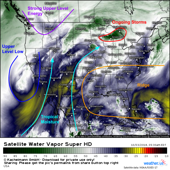
Water Vapor satellite imagery this morning highlights several features important to the severe weather setup in Wisconsin. First and foremost is the disturbance that will actually be responsible for the strong dynamics over the Upper Midwest, which is currently digging ESE across Montana. Farther south, SW flow between an upper level low off CA and a mid level ridge over the Southeast is funneling Pacific moisture north, including that from the remnants of Rosa. This means that storms today will have plenty of moisture to work with. On the smaller scale, some ongoing storm activity is noted across WI this morning, which will add some complexity to the mesoscale setup later on.
Here’s a look at the setup this evening via the ECMWF’s thunderstorm composite map. The vectors, which correspond to winds at different heights, show strong jets both in the upper levels (blue arrows are 300mb winds) and lower levels (red arrows are 850mb winds). These jets are not unidirectional, thus leading to directional shear (changing wind direction with height) in addition to the speed shear (changing wind speed with height). This shear, combined with ample instability ahead of the cold front (highlighted in pink) will result in a very favorable environment for severe storms this afternoon/evening.
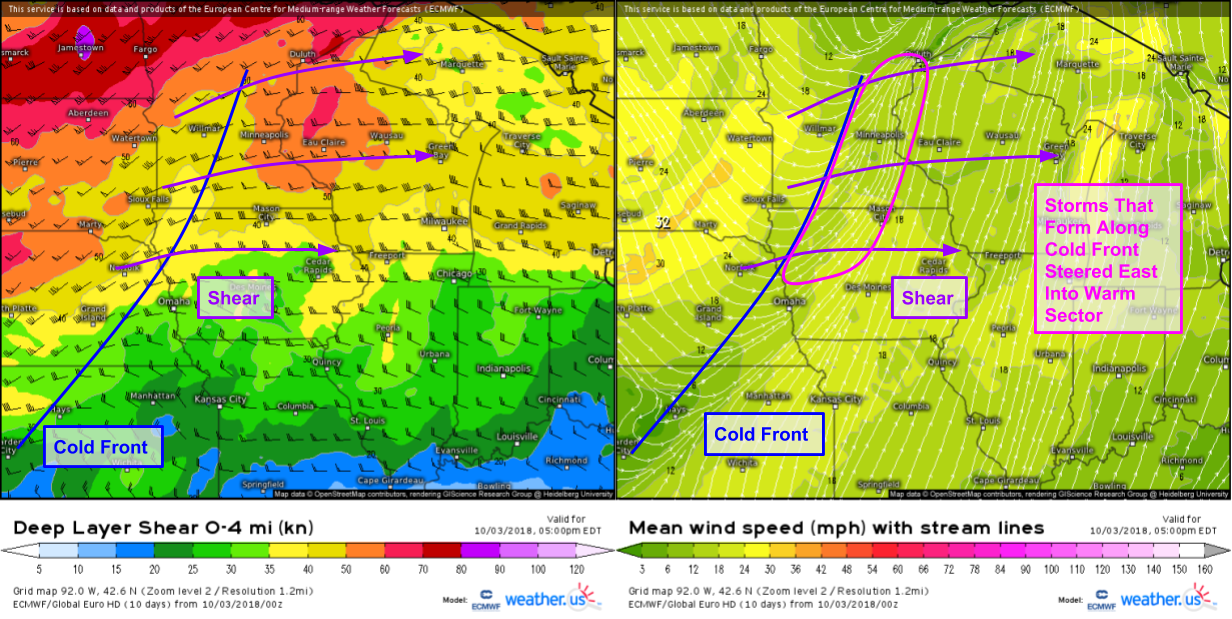
Here’s a look at shear and surface maps, which can work together to give us valuable information about the mode of storms and whether they’ll be discrete or more consolidated as a line. Drawing the cold front on the shear map, and the shear on the surface wind map, shows that the shear vector is oriented at approximately a 60 degree angle to the front. This means that cells that pop up on the front will be steered by the upper level winds off the front and into the warm sector. This is a favorable setup for discrete cells, which will be able to take advantage of the turning winds I discussed above. As a result, look for a few supercells to pop up initially this evening, which will be capable of all modes of severe weather including damaging winds, large hail, and tornadoes.
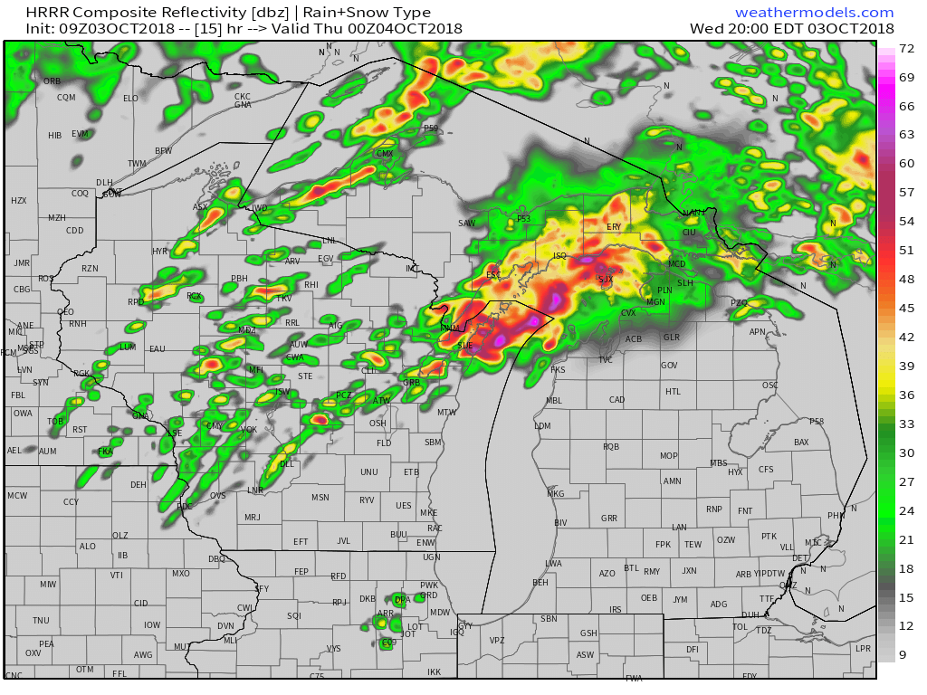
This HRRR simulated radar map shows that as the evening wears on, those discrete cells are likely to undergo a process known as “upscale growth” where the discrete cells merge and form a more linear system. As this process takes place, the threat will shift towards damaging winds, though tornadoes are still possible on the leading edge of the line. Map via weathermodels.com.
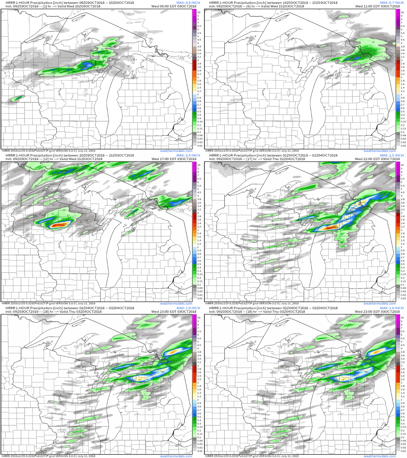
Severe weather will be the primary threat with today’s storms, but the HRRR loop of one hourly precipitation above shows some pockets of very heavy rain as well. Some of those heavy rain pockets will be moving over areas already seeing heavy rain this morning. Flash Flood Guidance (find it at lab.weathermodels.com) indicates that it would take about 1.5-2″ of rain in an hour to cause flash flooding in north-central Wisconsin. If you follow the HRRR’s precip maxima across this area this evening, you’ll see that the model is pointing to around 2″ of rain per hour in the heaviest core. Will the model actually be able to pinpoint this? Absolutely not. But it’s worth keeping an eye on, as the potential is clearly there for some flash flooding with the strongest storms. Thankfully, the front will be sweeping east fairly quickly, which will limit the potential for really serious flooding.
Track the storms with HD radar, GOES-East satellite imagery, and lightning analysis. For all our maps, you can click to zoom into county level, or use the menus to select “custom zoom” mode. The latest data can be accessed via the “refresh” button at the top left of the map (different from the browser refresh button!), and parameters/options can be toggled using the menus as well.
-Jack
