Severe Storms Expected In Parts Of The Mid-South Today
Hello everyone!
As we move into the spring season, our focus begins shifting from winter storms to severe weather outbreaks. While today’s severe storms are unlikely to be widespread or intense enough to qualify as an “outbreak”, they do merit discussion. Storms will form along a weak cold front moving east through the Southern Plains. Storms will pose all severe risks, including large hail, damaging winds, tornadoes, heavy rain, and lightning. This post will discuss what to expect from these storms, and some of the science behind forecasting them.
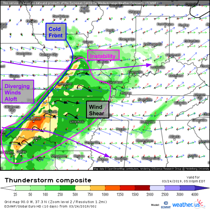
The overall setup is illustrated well by the ECMWF’s thunderstorm composite map shown here. The shading indicates instability (CAPE) available to fuel thunderstorms. Values above 250 (J/kg) will generally support thunderstorm activity, though of course the probability of severe storms increases with increasing instability (given sufficient wind shear and trigger). As for wind shear, following the colored vectors up through the atmosphere (black/red/green/blue vectors correspond to winds at 30ft/5,000ft/18,000ft/30,000ft) we see a decent change in both wind speed and direction with height, which will support rotating updrafts capable of producing severe weather. An approaching cold front will provide the energy to spark/trigger thunderstorm development, meaning we have all the ingredients needed for a severe weather threat.
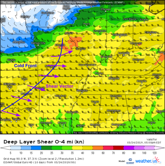
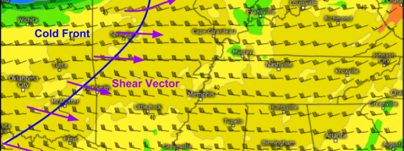
The cold front is fairly weak, and the map above shows shear vectors (rough proxy for storm motions) roughly perpendicular to the front. These two factors mean storms are likely to begin as discrete cells as opposed to a squall line. Given favorable shear profiles shown by the above thunderstorm composite map, these cells are likely to become supercells which are notoriously effective in producing severe weather. Supercells will bring large hail and the threat for tornadoes in addition to damaging winds, heavy rain, and lightning.
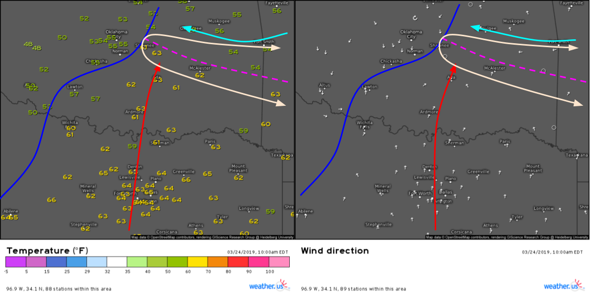
Given weak low level winds and thus a lack of near-surface wind shear, tornado threats today will depend largely on very small scale interactions between storms and boundaries. One such boundary is noted on this morning’s surface analysis across SE OK and W AR. Note the warmer temps south of the boundary and a change in wind direction along the boundary. This appears to be leftover from yesterday’s storms, and while its reflection in current plots is a bit masked by daytime heating, the energy associated with it remains intact. If a storm were to develop in proximity to this boundary, the energy from the boundary could help the storm form a tornado. If you’re curious about that process, check out this post from back in 2017 analyzing a case of (suspected) boundary-assisted tornadogenesis near Fargo ND.
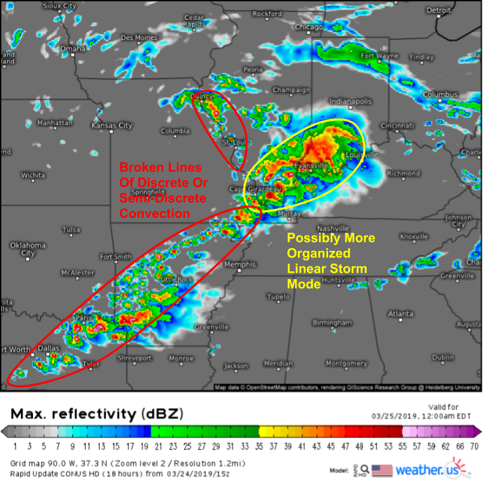
As far as the overall forecast goes, storms will get going on the later side this evening with the radar looking perhaps somewhat like this by 11 PM CST. A long line of broken, semi-discrete storms is likely to extend from around Dallas up towards Cape Girardeau, where a more organized conglomeration of storms is possible closer to the system’s warm front. Farther north near Saint Louis, some storms are possible but instability will be sorely lacking so aside from a few strong wind gusts, severe weather isn’t expected to be a major or widespread threat.
Because these storms are set to occur late in the evening into the overnight hours, be sure if you live in the risk areas you have a way of receiving warnings even if you’re asleep.
Storms will weaken as they roll towards the Southeast early tomorrow morning. Follow their progress and evolution with HD radar imagery, GOES-East satellite imagery, and lightning analysis data all available at weather.us. Remember to click on the maps to zoom in, and use the menus to the left of the images to explore other available options/parameters.
-Jack
