Severe Storms Expected In Parts Of Texas Today
Hello everyone!
With breaks in the seemingly endless parades of storms off both the East and West coasts over the past few weeks, a new weather threat will emerge across parts of the South this weekend: severe storms. Damaging winds, large hail, and tornadoes are all possible in different parts of the South either today, tomorrow, or Monday. I’ll break down today’s threat in this post, with more info on tomorrow and Monday’s setups forthcoming. Before digging into today’s details though, it’s important to get a general sense of the overall pattern, and why it’s favorable for severe weather.
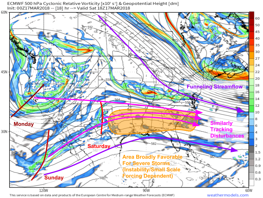
Here’s a look at the ECMWF’s 500mb vorticity (mid level spin) forecast for this afternoon. We can see both the individual disturbances responsible for each day’s severe threat (today, tomorrow, and Monday), as well as the broad pattern that’s supportive of severe weather in the south. Winds at and above 500mb almost exclusively blow parallel to the geopotential height contours shown on maps like this. So we can tell by following the height contours that there’s a funnel of sorts setting up over the East between high pressure over Southern Mexico, and low pressure over Atlantic Canada. This funnel will take disturbances ejecting out of the Western US trough, and guide them all along a similar path from the Southern Plains through the Deep South and towards the Atlantic Ocean. This is a broadly favorable pattern for severe weather in this area, but of course we need two other ingredients besides mid/upper level support to get severe storms: instability, and focused (mesoscale) lifting. These are the two parameters that will modulate severe weather chances each day, leading to some shifting around of the area of greatest threat. Map via weathermodels.com.
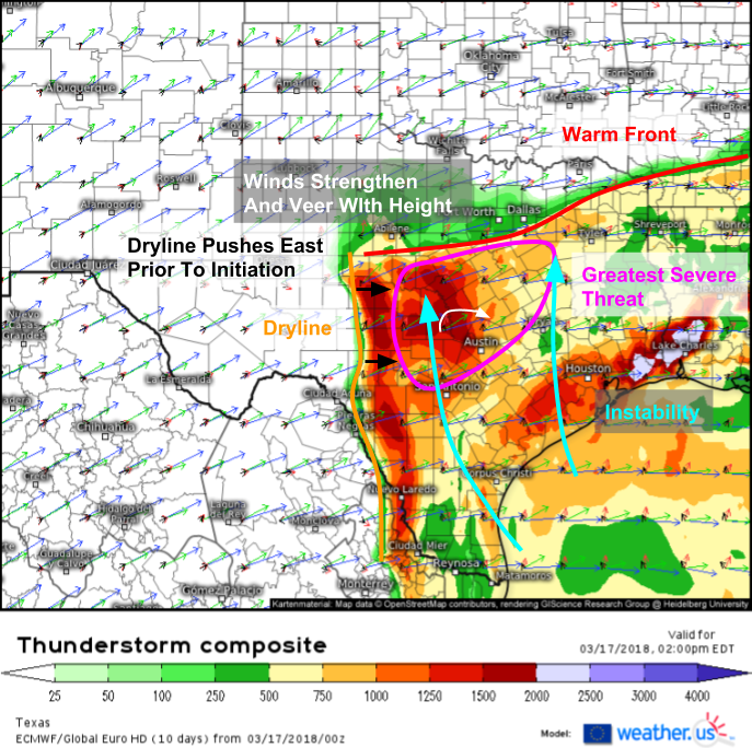
Here’s a look at today’s setup, which will be focused in parts of Central Texas. The base map is the ECMWF’s thunderstorm composite (what’s that?), which shows instability (CAPE) as well as wind speed and direction at the surface (black), 850mb (red), 500mb (green), and 300mb (blue). The more winds veer (turn clockwise) and strengthen with height, the more storms can spin. Spinning storms are responsible for some of the most intense severe weather, such as tornadoes and large hail, as well as damaging winds. Of course, you also need instability for strong storms, which is displayed on the map as the colored shading. Finally, you need some surface or near surface boundary to help focus lift and initiate storms. These can also be spotted on the Thunderstorm Composite map, as instability gradients that are located near or over changes in the surface wind direction. Because we can see all three ingredients needed for severe storms on one map, the Thunderstorm Composite is the single best tool in your arsenal for predicting severe weather ahead of time using model data.
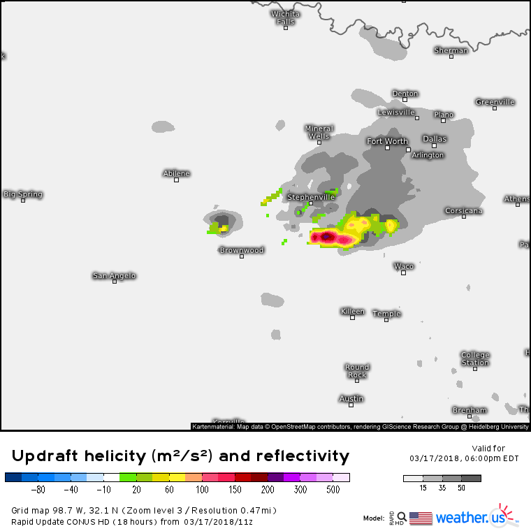
Here’s a look at another one of our model products that show the results of what we discussed above. This shows simulated reflectivity (gray shading) and a parameter known as updraft helicity (colored shading) which is a measure of how intensely the updraft of a storm is spinning. The more UH, the more intense the spin. Notice the area of storms that the HRRR model is forecasting in the area we highlighted above as being the greatest threat for storms. Also note that the model forecasts some of these storms to have some strong spin, a result of the wind profiles we were able to see via the Thunderstorm Composite. Any storms that form in this area and are able to utilize those wind profiles will spin and be capable of large hail and tornadoes, in addition to damaging winds, heavy rain, and dangerous lightning.
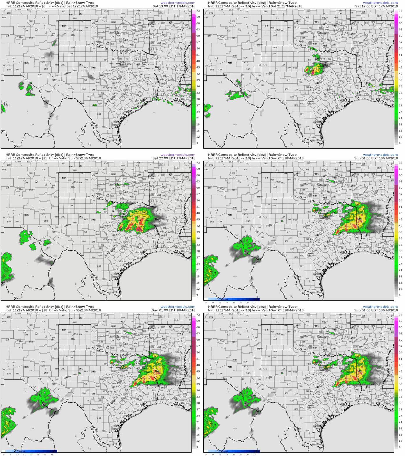
Here’s the HRRR’s simulated radar showing the development and evolution of storms today. As with any model simulated radar render, it’s not meant for precision, but rather for a general guide to how a system develops over the course of the day. GIF via weathermodels.com.
Once storms form this afternoon, track them with the wide array of tools we have at weather.us. Watch small cumulus clouds grow into towering thunderstorms with GOES-East satellite imagery https://weather.us/satellite/texas/satellite-color-superhd-5min.html#play, find the cores of the strongest storms with HD radar imagery https://weather.us/radar-us/texas/reflectivity/KDYX.html#play, and see if they’re spinning with HD velocity data https://weather.us/radar-us/texas/velocity/KDYX.html#play. Finally, watch current observations to keep tabs on the building instability, as well as the location of important features such as the warm front and the dryline. Current temps https://weather.us/observations/temperature-f.html dew points https://weather.us/observations/texas/dewpoint-f/20180317-1300z.html and wind direction https://weather.us/observations/texas/wind-direction/20180317-1300z.html will be the parameters that will be most important today. Click the refresh button at the top left of the image to get the latest data. Click any of the maps at the links to zoom into county level for a closeup look at what’s happening in your neighborhood.
More storms are expected tomorrow, with the threat area shifting a little farther to the east.
Texas won’t be the only area dealing with some active weather today, though the storms in Texas will certainly be the most impactful of today’s systems.
GOES-East WV satellite imagery (what’s that?) shows the parade of severe weather disturbances lined up over the Southwestern US/Eastern Pacific, as well as a few other features responsible for some minor active weather. The storm that brought rain, snow, ice, and storms to parts of the Plains yesterday has unraveled last night, and is now little more than a strung out ribbon of energy stretching from Alberta to West Virginia. On the leading edge of the eastern part of this energy, some light wintry precipitation is falling from Ohio down through the mountains of West Virginia and western Virginia. While no major imapcts are expected, watch for slick spots in this area due to light snow, sleet, and freezing rain. Out west, a large trough remains anchored near the CA/OR border, with lift and some remnant Pacific moisture out ahead of it. The storm is cut off from any strong plumes of deep tropical moisture, so no organized heavy precipitation is expected, but valley rain and mountain snow showers will continue today across a large part of the Rockies as this system slowly drifts east.
For more information on your local forecast: https://weather.us/
For more information on the local forecast for ME/NH: https://forecasterjack.com/2018/03/17/arctic-cold-front-arrives-today/
-Jack


