Repeated Rounds Of Heavy Rain Will Increase Flood Concerns In Parts Of The Plains Today And Tomorrow
Hello everyone!
The biggest weather related concern this morning across the US is the developing flash flood threat in parts of the Central Plains. Thunderstorms have already dropped copious amounts of rain on parts of Eastern Kansas this morning, and at least two more rounds of storms are expected this afternoon and tomorrow across the same areas. This post will outline some of the dynamics behind these storms as well as what to expect in terms of rain totals and timing.
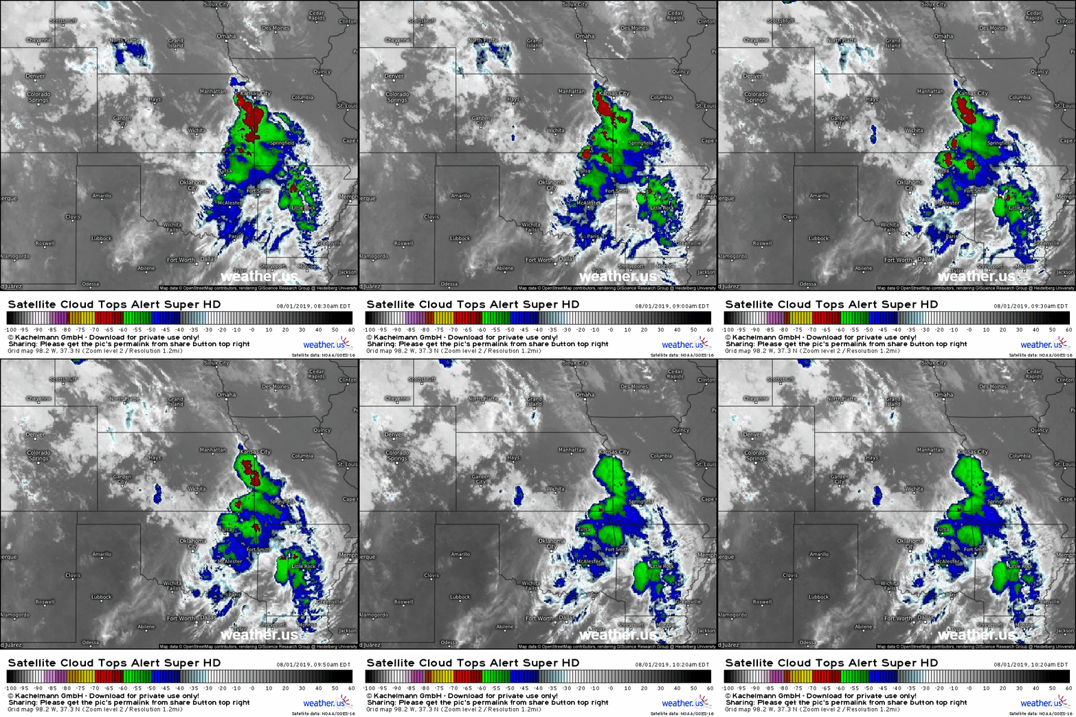
GOES-East satellite imagery from this morning shows an area of thunderstorms moving along a roughly north-south oriented axis stretching from the KS/NE/MO border area just west of Kansas City and down towards NE OK. The three-hourly loop shown above highlights the SSE movement of the individual storm cells (local cloud top temperature minima) roughly along the axis described above. Any time you see thunderstorms moving over the same areas repeatedly like this, it’s time to worry about flash flooding.
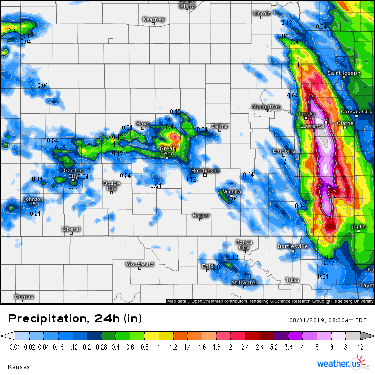
Radar estimated precipitation totals over the part of Eastern Kansas that we’re watching for flash flooding have already exceeded 3-5″ over the 24 hour period ending at 7 AM CDT this morning. There have already been reports of flooding in the area SW of Kansas City, which is a signal that soils in this area are unable to absorb much in the way of additional water.
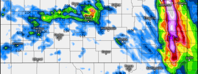
The best way to visualize the capacity of a particular area to absorb water into the soil (as opposed to letting it collect and run off at the surface) is with the Flash Flood Guidance tool. This map displays the approximate amount of rain needed in a three hour period to cause flash flooding. Note that values across the part of Kansas impacted by this morning’s thunderstorms have dropped below 0.5″ meaning that all you need to get flash flooding is a couple hours of moderate rain. Heavy rain would only cause more serious problems. Map via weathermodels.com.
With that in mind, what does the forecast look like for these areas during the next couple days? To get heavy rain you need a lot of moisture, and some way of squeezing that moisture out of its vapor form and into liquid form. Let’s take a look at the forecast for both of those ingredients.
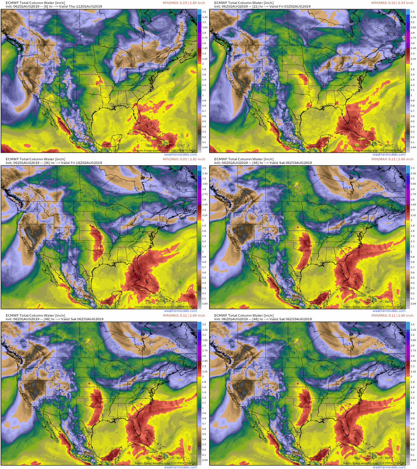
The best way to assess the presence of moisture in the atmosphere is via the Precipitable Water parameter (abbreviated PWAT), also sometimes referred to as Total Column Water, shown below. This parameter displays the model’s forecast for how much rain would fall at a given point if all the moisture in the atmosphere above that point were to be suddenly condensed into liquid. Note that this is *not* a ‘maximum potential rainfall’ parameter because the atmosphere is always in motion, and if more moisture is moved into an area where heavy rainfall is occurring, the rain can continue to accumulate well past the PWAT value.
An increase in PWAT values is forecast across our area of interest, eastern Kansas, over the next 48 hours. PWAT values above 2″ signal an airmass very ripe for heavy rain, and are shown in red on the map. The increase in moisture is attributable to a strengthening low level jet that’s transporting moisture into the region from the Southwest (where the annual monsoon is now underway) as well as the Gulf of Mexico. That low level jet will also help provide the lift needed for thunderstorms to develop and drop more rain tonight and tomorrow. GIF via weathermodels.com.
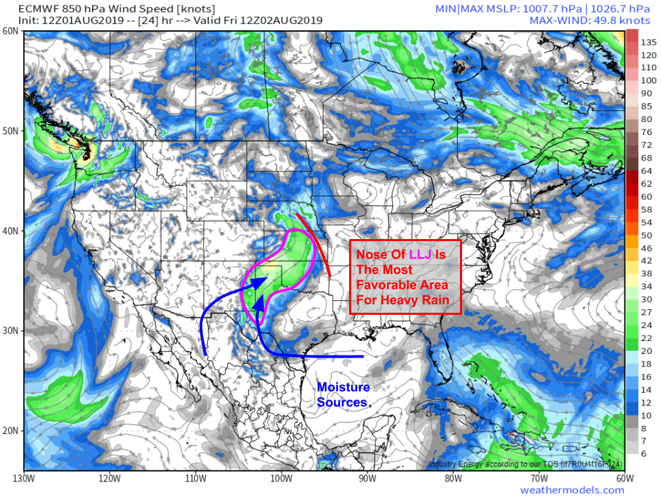
The low level jet is best visualized with 850mb (~5,000 feet above sea level) winds, and sure enough the local wind max over TX/OK/KS is easily visible on this ECMWF 850mb forecast for tomorrow morning. The best dynamics for heavy rain will be found at the leading edge of the low level jet where convergence (upward motion) will help storms develop. Those storms will then have access to a deep supply of fuel both in terms of instability and moisture being transported in by the jet. Map via weathermodels.com.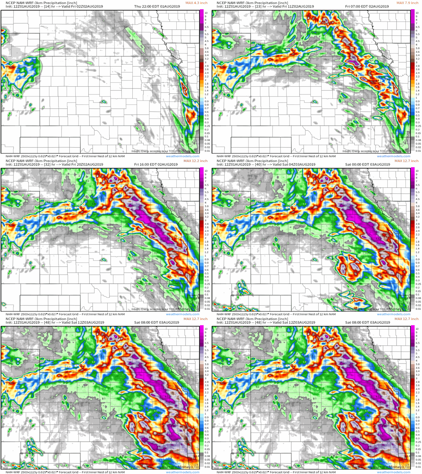
Sure enough, high resolution models including the NAM shown here are forecasting another round of strong storms over the area right at the nose of the LLJ from Central Nebraska through Eastern Kansas. The exact totals forecast by the model are less important than the general picture: another round of very heavy rain is expected to fall over already-saturated parts of Eastern Kansas beginning tonight and continuing through the day tomorrow. Now is a good time to prepare for high water if you live in parts of this area that are either flood prone, or near flood prone areas. In events like this, even places not typically accustomed to high water during heavy rain will see flooding. GIF via weathermodels.com.
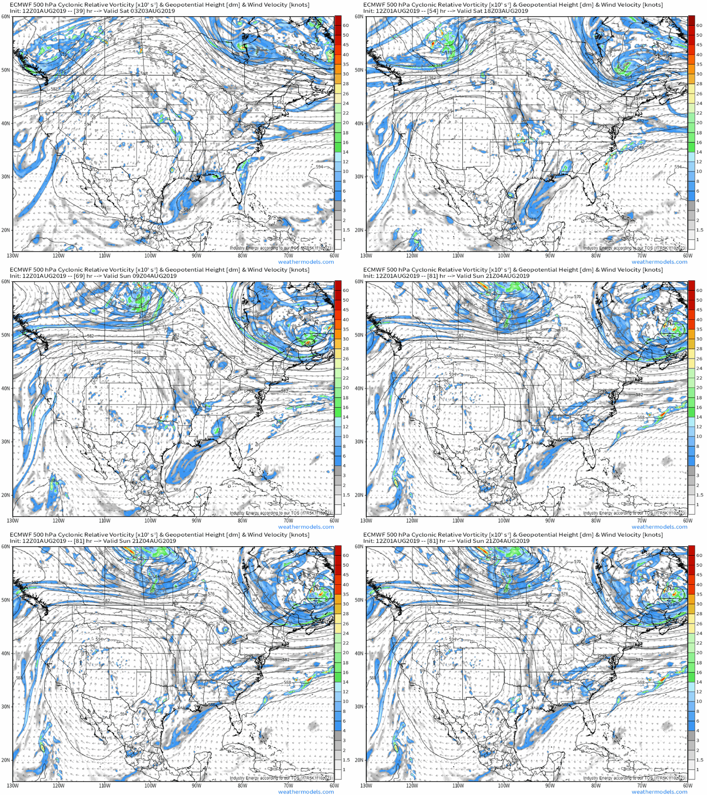
By Saturday, the upper level disturbance responsible for organizing the low level jet and providing additional lift for thunderstorm development will shift south into Oklahoma as the 500mb vorticity loop above shows. The axis of heaviest rain will shift south along with the disturbance, and Saturday’s heaviest rains will be focused from SE KS down through eastern OK. The slow forward motion of the storms, along with the copious amounts of moisture available, will mean that flash flooding will continue to be a threat. That being said, the rain on Saturday will be falling over areas not nearly as rain-soaked as eastern Kansas, and thus flooding issues will likely be more localized. That doesn’t mean the rain will be any less dangerous though, and residents of flood-prone parts of eastern Oklahoma should take today and tomorrow to prepare for potential high water on Saturday. GIF via weathermodels.com.
You can follow along with the storms using HD radar imagery and GOES-East satellite imagery. Curious how much rain has fallen? You can check either radar-derived precipitation estimates or actual station observations to find the answer. Press the little refresh button at the top left of any of our maps to get the latest data.
-Jack
