Rainy And Raw Weather Expected For The Boston Marathon Tomorrow
Hello everyone!
Runners and spectators along the route of the Boston Marathon will have to contend with bands of heavy rain, cold temperatures, and gusty winds tomorrow as the storm system that brought severe weather to parts of the Central and Southern US over the past few days moves eastward. In this post I’ll go over the forecast for the Boston area, but will use tools that we have available for areas across the US and the world. If you’re interested in skipping over some of the analysis and heading straight to the spot where I outline what to expect, scroll down to the “Overview” section.
Setup
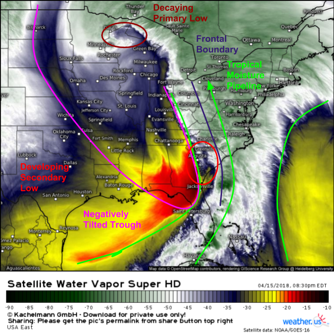
GOES-East water vapor satellite imagery (what’s that?) this evening shows a highly amplified pattern over Eastern North America, with a deep trough digging from Canada to the Gulf of Mexico, and a rich stream of tropical moisture surging north ahead of it. This tropical moisture feed is one of the ingredients that will contribute to nasty weather conditions for the marathon in Boston. A frontal boundary is located under that tropical moisture pipeline, and it will join up with a wave of secondary low pressure developing to help wring the moisture out of the air, resulting in heavy bands of rain.
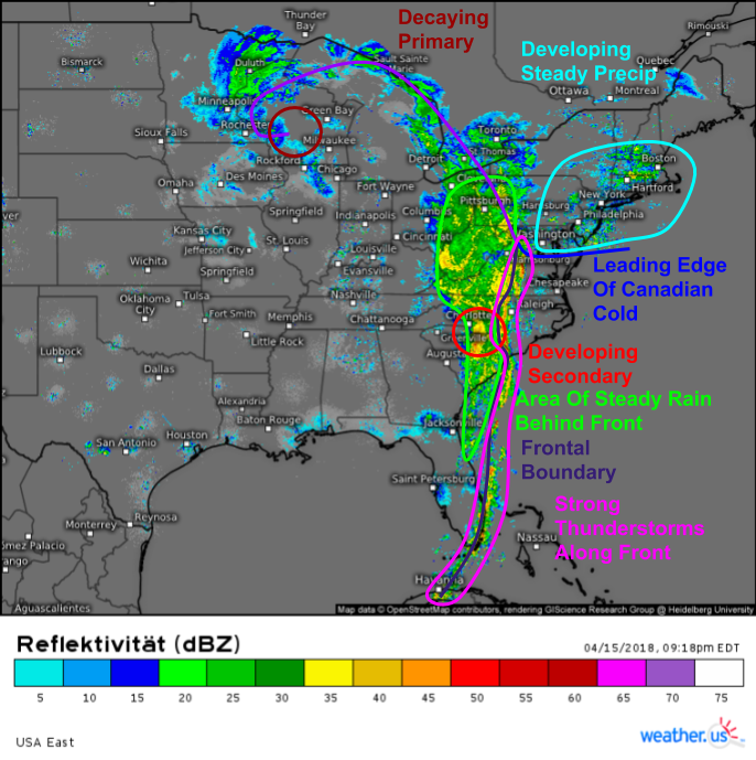
Composite radar imagery this evening highlights all the same features that the GOES-East imagery revealed, plus what some of their impacts look like on precipitation. We can clearly see the front on radar imagery, with strong thunderstorms along the front itself and a larger area of steadier rain behind the front as the front’s circulation taps into that deep tropical airmass discussed earlier. As that tropical airmass flows north closer to Boston, it’s running into some low level cold air. An area of steady precipitation is developing to the north of the leading edge of that cold air, noted as a frontal boundary near DC. It’s this area of precip that runners will have to contend with first as they start off from Hopkinton tomorrow morning.
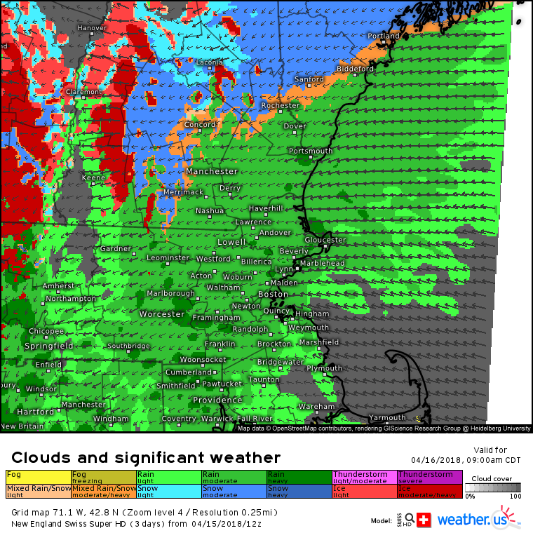
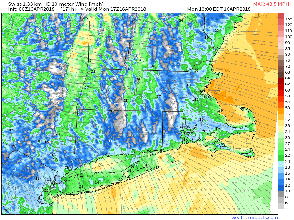
Here’s a look at the Swiss Super HD model’s interpretation of that area of steady pre-frontal precipitation over Eastern New England as the first wave of runners departs at 10 AM EDT. Most of the rain at this point will be moderate in nature, though some heavier downpours are possible due to the tropical nature of the airmass. Thankfully while temperatures will be cold, they’re not going to be cold enough for snow or mixed precipitation, which will be confined to the higher elevations of the Berkshires as well as Northern New England. Unfortunately, rain won’t be the weather’s only adverse impact on the race.
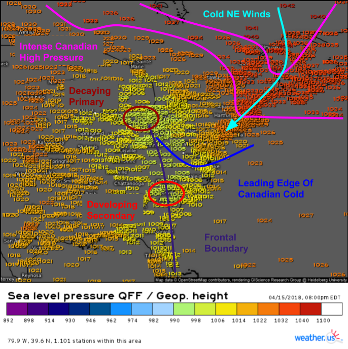
Surface pressure observations this evening do a great job highlighting the culprit behind the two additional weather related challenges runners will have to contend with in addition to the rain: cold temperatures and a strong headwind. As the low pressure area we’re watching develops over the Carolinas and moves north through the Mid Atlantic, an unseasonably intense area of Canadian high pressure is anchored in Northern Quebec, and one of its many sprawling branches is spilling cold air down the east side of the Appalachians. This airmass is so cold that Boston saw ocean effect snow showers earlier today. Temps will warm slightly by start time tomorrow, but will still be quite chilly, likely in the mid to upper 30’s.
The gradient between the developing low pressure to the southwest and the strong high pressure to the northeast will result in developing gusty winds tomorrow. Because winds flow counterclockwise around areas of low pressure and clockwise around areas of high pressure, these winds will be out of the east-southeast in the Boston area. Unfortunately for runners, this will be more of a headwind than not as they make their way from the western suburbs into the city of Boston itself.
Overview
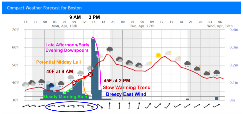
Finding the analysis a little too time consuming or complicated? No worries, we have at-a-glance forecast information too! Here’s a look at our Compact weather forecast for Boston for the next couple days. Notice how it has all the information you need to make plans conveniently displayed on a single graph. We can see the cold temperature forecast, with temps right around 40 degrees at the start only slowly warming into the mid 40’s by the time most runners will be finishing around 2-3 PM. We can also see precipitation patterns via the dark bars that represent accumulated rainfall each hour. The taller the bar, the more rain is forecast to fall in a given hour, and thus the heavier the rain is predicted to be. Notice that the steady/moderate morning rain is followed by a quick lull around lunchtime before the downpours associated with the remnants of today’s Mid Atlantic line of severe storms brings much heavier rain later in the afternoon/early evening hours. The wind barbs at the bottom of the graph fill in the final gap, showing a steady easterly headwind of 15-20 mph (not including gusts).
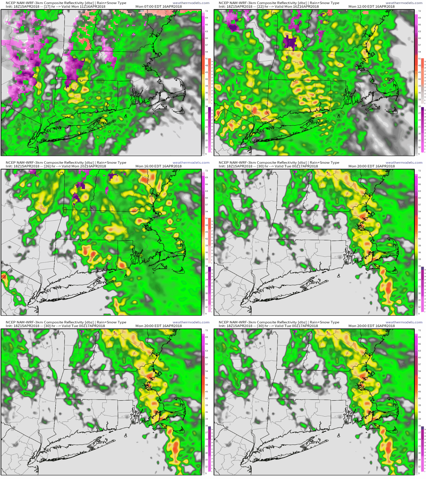
For a different type of quick overview, check out this simulated radar animation from weathermodels.com. It does a good job of highlighting how the morning’s area of steady rain briefly tapers off to a short lull right around lunchtime before a line of heavy downpours moves in for the evening. While these downpours aren’t expected to cause any major flooding issues, some localized urban/small stream flooding is possible due to the tropical nature of the airmass that will be in place. Downpours will move northeast of the city early tomorrow night with drier conditions expected Tuesday.
Track the rain tomorrow town by town along the course with our county level HD radar: https://weather.us/radar-us/1469cb16ee5c04216e775f663cad8078/reflectivity/KBOX.html#play. For more information on Boston’s weather, check out our Weather Overview page for the city. Use the search box on the upper left hand side of that page to get the same set of data for any town or city in the world. For a full tutorial on how to use the Weather Overview interface, click here.
-Jack
