Quiet Weather Today, But A Storm Brews For Sunday
Hello everyone!
While today’s weather will be fairly quiet across the US, you don’t have to go far to see a storm brewing. Sunny skies are forecast today across New England, but by Sunday night, winds may be gusting to hurricane force as a powerful low moves north. Let’s dig into this system a little bit, including what the forecast is currently, what could change, and how to use the tools on weather.us to make sense of it all.
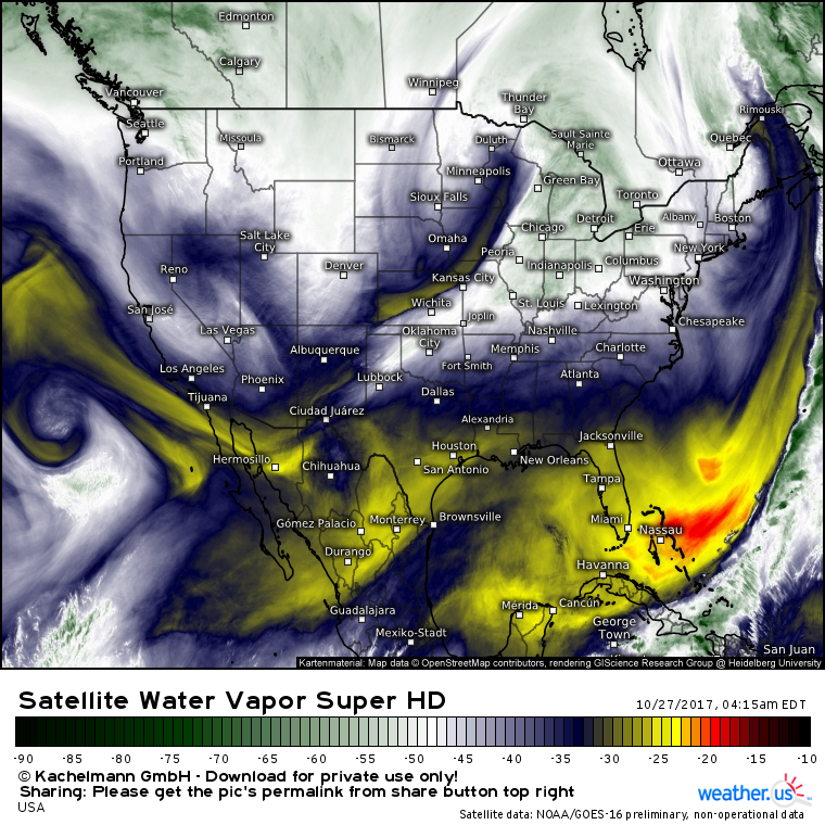
GOES-16 water vapor satellite imagery (what’s this?) shows a disturbance moving southeast across Minnesota this morning. Behind it, cold air is pouring in from Canada. This cold air will help support some light snowfall across parts of Minnesota today. The cold air is mostly important because it will serve to enhance the temperature gradient when we add a tropical airmass to the equation.
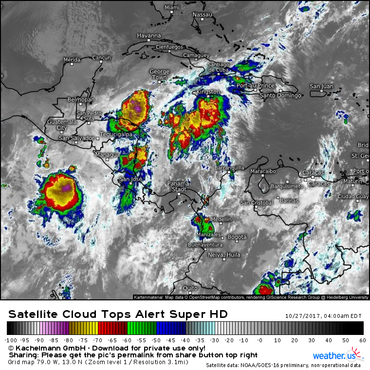
This GOES-16 cloud top infrared satellite image (what’s this?) shows an area of disorganized showers and thunderstorms over the Western Caribbean sea. While development into a formal tropical system is not expected, this disturbance will become entrained in the developing East Coast storm, bringing tropical moisture and additional energy to the table.
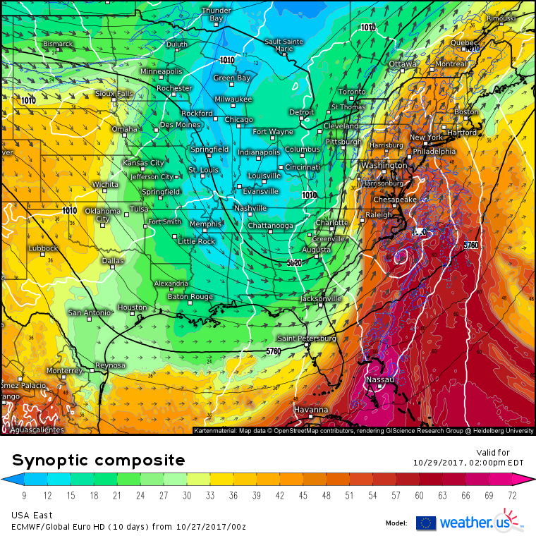
The synoptic composite from the ECMWF (what’s that and how is it used?) does a good job highlighting the “why behind the what” when it comes to the development of this storm. The tropical disturbance is pictured south of the Outer Banks (white circle that indicates a closed surface low), and has done it’s job, bringing a plume of warm and extremely moist air up into the Mid Atlantic (plume of red/orange shading, indicating tropical moisture, surging into the Mid Atlantic). The jet stream will play a very important part in this forecast as well. Notice the large vectors pointing north from Jacksonville Florida up to Toronto. These vectors indicate an area of very strong southerly winds embedded within the larger jet stream. This is known as a jet streak. Our developing storm is in the right hand side of the entrance region to this jet streak, meaning that it’s in a very favorable environment for development.
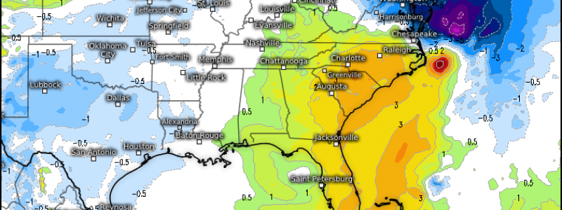
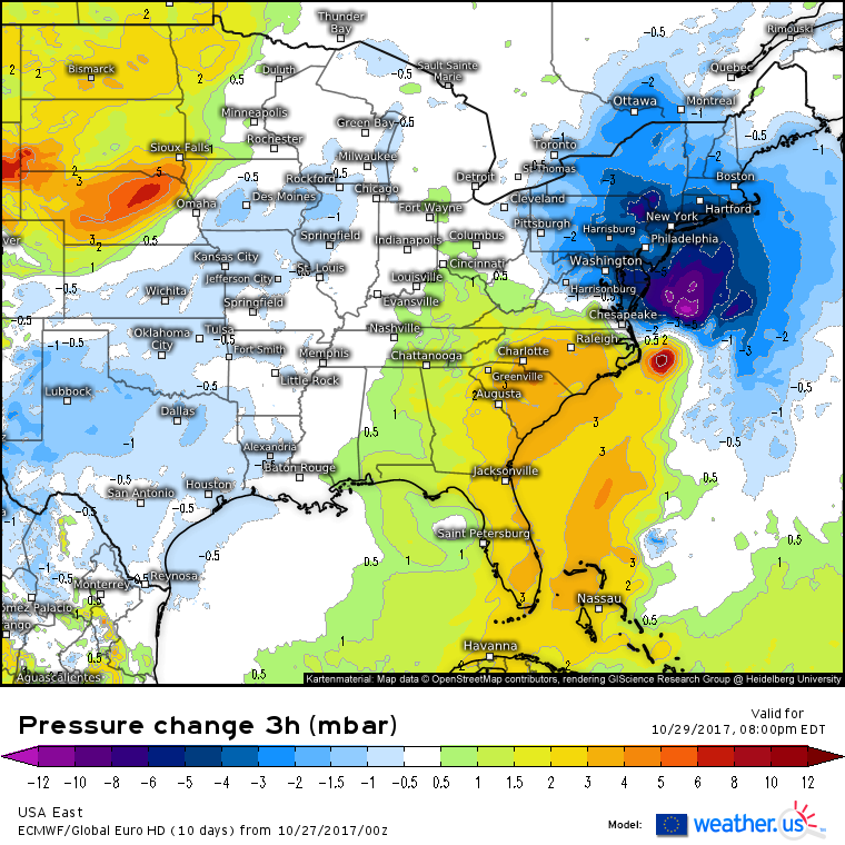
This map shows the surface level response to the dynamics discussed above. This map shows the change in pressure over a given 3 hour period, in this case for 5-8 PM Sunday evening. Notice the large area of pressure falls off the Mid Atlantic coast, that is larger than the pressure rises behind the storm. This indicates a strengthening low pressure system, as there are more pressure falls than pressure rises.
So what does all this mean for the sensible weather on the East Coast Sunday night into Monday?
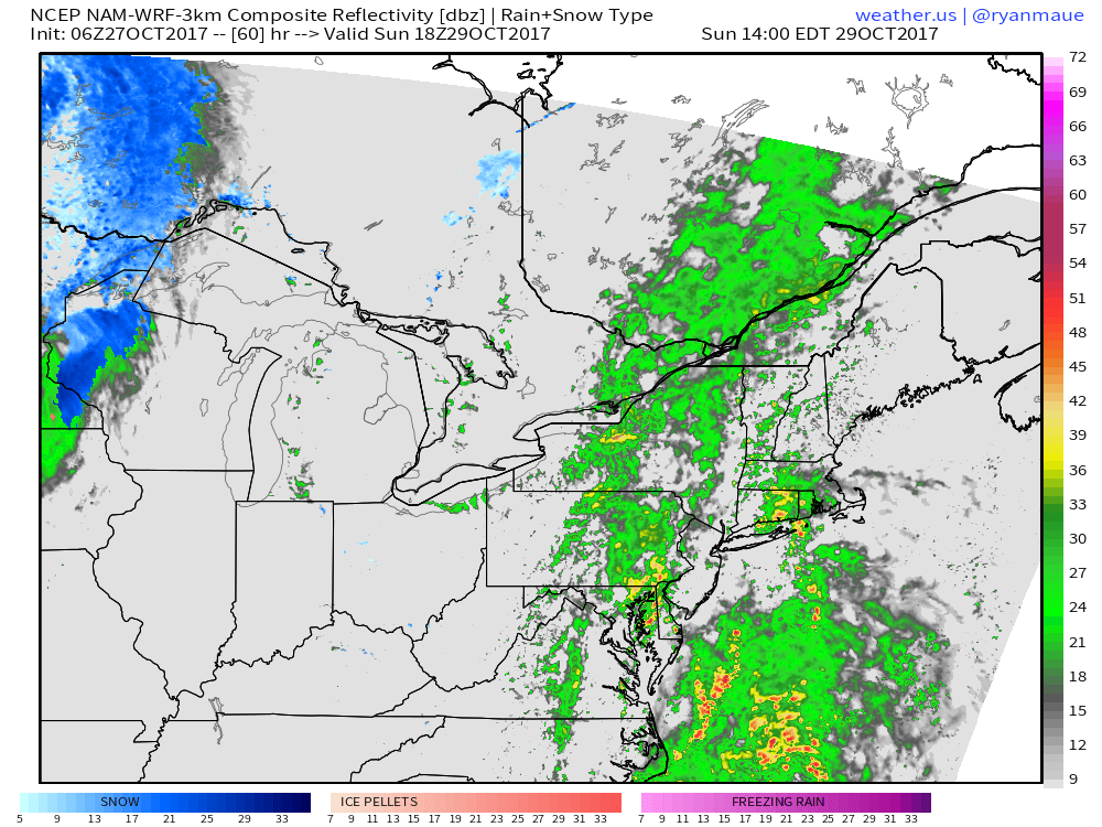
It’s going to be a rough ride for some as this storm moves in. Rain will begin Sunday morning as the cold front begins to tap into the moisture of the tropical low. Rain could be heavy at times, but through Sunday afternoon (2 PM radar pictured above), no overly severe impacts are expected. SE winds will be on the increase Sunday as well, but it won’t be until Sunday night that they really howl.
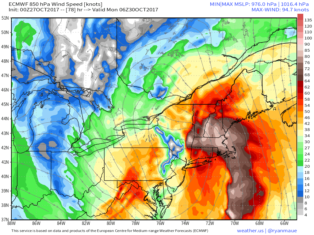
By Sunday night, those SE winds will indeed be howling across New England. The map above shows the ECMWF’s forecast wind speed at 5,000 feet, NOT the surface. I show this map to highlight how crazy strong the winds are in the Low Level Jet (LLJ), that isn’t far off the ground. Any heavy downpours can bring some of those winds down to the surface as gusts. Generally speaking, the maximum wind gusts that the coast will see in events such as these are only a fraction of the winds available in the LLJ, but even a fraction of 90 knot winds is still enough to cause some problems.
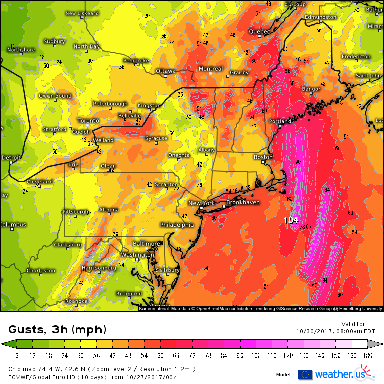
This is the ECMWF’s wind gust forecast for early Monday morning as the storm moves into Central New England. I show this not because I believe every value listed (100+ mph gusts, even offshore, are not expected), but because it highlights a process that will be important. Notice the pattern (not intensity) of hurricane force wind gusts just offshore. They’re oriented in swaths that track along the front. What’s going on there? The ECMWF model is predicting clusters of thunderstorms in those areas, as shown by its simulated radar product. These thunderstorms are mixing down some of those LLJ winds we discussed above. While it’s impossible for the model to guess exactly where these thunderstorms, and thus the wind cores, will track, the idea that thunderstorms can mix down some of those stronger winds aloft, leading to hurricane force wind gusts along the coast, is an important one.
The core of the winds will be located to the east of the low’s track, across the New England coast. Rain will be the main story west of the track, in New York.
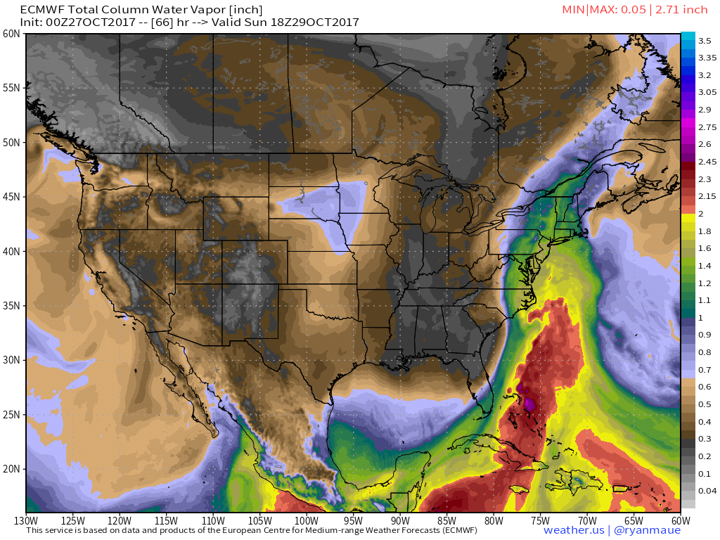
We’ve already discussed how the tropical disturbance in the Caribbean will contribute significant amounts of tropical moisture to this storm. Here is that idea visualized through the ECMWF’s precipitable water product. This is basically a way of quantifying atmospheric moisture content. Any values over 2″ indicate significant tropical moisture, and sure enough, an entire plume of 2″+ PWAT values is pointed at the Northeast on Sunday. The dynamics of a strong cold front and intensifying storm will be more than enough to wring this moisture out, leading to impressive rainfall totals across parts of New York and Pennsylvania.
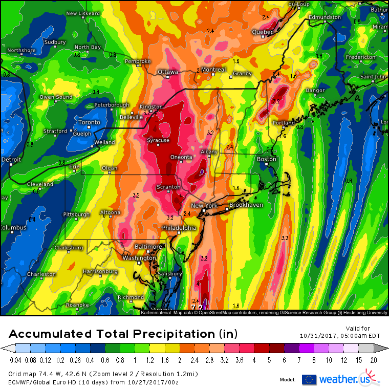
This total precipitation forecast from the ECMWF model highlights the general distribution of rainfall from this system. As with the winds, there’s no need to get too caught up in exact values here. This map would be just as valuable with all the numbers taken off. The most widespread heavy rains will be found to the west of the center, over New York and Pennsylvania. This area will see the best combination of strong dynamics and tropical moisture, resulting in a widespread area of 2-5″ of rain. Farther east, across New England, rainfall will primarily depend on those convective clusters we discussed above. If you happen to get one of those clusters, you’re likely to see a couple inches of rain. If not, you’re likely to see around an inch of rain as the front moves through.
Remember that the exact placement and intensity of both the rain and the wind will depend on exactly where the low tracks, and exactly how much of the tropical energy can phase into the core of the low. Upper level energy maps show why there’s a little bit of uncertainty there.
You can clearly see a tale of two disturbances here. One shows up cleanly over the Southeast US, with an area of strong vorticity (spin/energy) centered near Atlanta. That’s the polar disturbance that’s currently over Minnesota. The other disturbance is a strung out jumbled mess that stretches from Montreal to the Caribbean. This is the energy from the tropical low, currently near Nicaragua. Exactly how much of that energy can funnel into the core of the system has yet to be determined, and it will have important track/intensity implications for the storm itself.
You can see how models might struggle to interpret this jumbled area of energy. We can use the models to figure out that it will exist, but there are limitations on what the models can do, and trusting the model to sort out each and every one of those pockets of energy isn’t a good idea. That’s why all of the model images I’ve presented here have been to show general trends/distributions, not specific values (i.e. “hurricane force wind gusts could impact the New England coast”, as opposed to “model x forecasts y wind speed for Cape Cod”).
When using the model forecasts on weather.us, remember this. The models exist to give us general ideas about what the weather might be, not make specific value forecasts, especially in complex setups such as this one. It’s always a good idea to compare different models that will interpret that area of infinitely complex energy differently. At weather.us, we make that really easy, with our Forecast Ensemble and Forecast XL products. Between the two, you can compare several dozen model forecasts to get a sense of the range of possible outcomes. I talk more about ensembles in this video, which, while it focuses on tropical system, has information that applies here too.
By Monday evening, our storm will be long gone as drier air moves into the Northeast. A period of generally quiet weather is likely to follow this storm as a cooler and drier pattern sets up heading into November.
I’ll have much more on this storm as it gets closer!
For more on your local forecast: https://weather.us/
For more on the local forecast for Maine and New Hampshire: https://forecasterjack.com/2017/10/27/cooler-and-drier-today/
-Jack


Great Write-up as always Jack!
Nice morning read Jack. Keep up the great work.